- Home
- :
- All Communities
- :
- Products
- :
- ArcGIS CityEngine
- :
- ArcGIS CityEngine Questions
- :
- Re: CityEngine Terrain Map
- Subscribe to RSS Feed
- Mark Topic as New
- Mark Topic as Read
- Float this Topic for Current User
- Bookmark
- Subscribe
- Mute
- Printer Friendly Page
CityEngine Terrain Map
- Mark as New
- Bookmark
- Subscribe
- Mute
- Subscribe to RSS Feed
- Permalink
- Report Inappropriate Content
I have some issues in creating a terrain in city engine. I have create a New Scene and add some data from OSM then I follow the
steps that are described in Tutorial 2/Part 1, using as Heightmap a georeferenced DEM image and as Texture a georeferenced image
from OSM. But, althougn in Arcmap they are correct in CityEngine I receive the following error: The data is located too far from
the current scene's contents. Either edit the (geo-)location of the data, choose an adequate projection, or import it into a new
empty CityEngine scene.
I have done the opposite, to create a New Scene create first the Terrain and add after the data, but I received again
the error above.
I really cant find out what is going wrong
- Mark as New
- Bookmark
- Subscribe
- Mute
- Subscribe to RSS Feed
- Permalink
- Report Inappropriate Content
Hi Diego
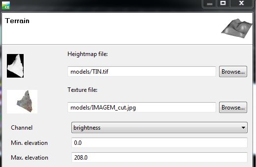
Try create a texture.jpg
For example, I have a TIN.tif and a "picture" of my TIN in jpg format.:
- Mark as New
- Bookmark
- Subscribe
- Mute
- Subscribe to RSS Feed
- Permalink
- Report Inappropriate Content
Hi Luiz
I followed your advice however still not working and having a black texture. I have exported to several formats such as JPG, PNG, TIFF, etc but nothing work.
Thanks for helping.
Claudia
- Mark as New
- Bookmark
- Subscribe
- Mute
- Subscribe to RSS Feed
- Permalink
- Report Inappropriate Content
Hello Claudia
Can you view the texture with an standard image viewer?
If this is possible, it also should work in CityEngine.
To further investigate this, I'd need your image data.
- Mark as New
- Bookmark
- Subscribe
- Mute
- Subscribe to RSS Feed
- Permalink
- Report Inappropriate Content
I have the same exact problem the image works in ArcMap and ArcScene but when I import it as a texture for my dtm it only shows up black. I REALLY NEED TO GET THIS WORKInG. Can anyone help me
- Mark as New
- Bookmark
- Subscribe
- Mute
- Subscribe to RSS Feed
- Permalink
- Report Inappropriate Content
CityEngine Terrain Layer support a wide range of image formats. But there might be some, that are not yet supported.
Please provide more information about:
- image format
- size
- bitdepth
- georeferencing
- « Previous
- Next »
- « Previous
- Next »