- Home
- :
- All Communities
- :
- Products
- :
- ArcGIS Business Analyst
- :
- ArcGIS Business Analyst Questions
- :
- Re: BA Spatial Join Question
- Subscribe to RSS Feed
- Mark Topic as New
- Mark Topic as Read
- Float this Topic for Current User
- Bookmark
- Subscribe
- Mute
- Printer Friendly Page
BA Spatial Join Question
- Mark as New
- Bookmark
- Subscribe
- Mute
- Subscribe to RSS Feed
- Permalink
- Report Inappropriate Content
Hi All,
I've got a spatial join question and I hope it makes sense. I've got a set of 8 block groups and I want to know what county they are inside. When I do a spatial join (intersect/one-to-one), I'm getting an output of 8 block groups back, but the county is not correct. 6 of the block groups should be in Yuma County, CO but I'm getting counties that should be in Yuma county saying that they are in a county that is next door. Any idea how I can fix this or what I'm doing wrong? I opened a ticket with ESRI just now and the analyst worked on it for almost an hour and couldn't figure it out. He tried a bunch of different spatial joins, etc.
- Mark as New
- Bookmark
- Subscribe
- Mute
- Subscribe to RSS Feed
- Permalink
- Report Inappropriate Content
Brandon,
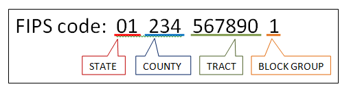
I assume you got this sorted out a while back but for any others find this it is pretty straight forward finding out what county a block group is in as long as it has a 12 digit FIPS code. The attached image shows the break down of a block groups FIPS code.
Regards,
Jason R.