- Home
- :
- All Communities
- :
- Developers
- :
- ArcGIS API for Python
- :
- ArcGIS API for Python Questions
- :
- This GIS does not support spatial analysis
- Subscribe to RSS Feed
- Mark Topic as New
- Mark Topic as Read
- Float this Topic for Current User
- Bookmark
- Subscribe
- Mute
- Printer Friendly Page
This GIS does not support spatial analysis
- Mark as New
- Bookmark
- Subscribe
- Mute
- Subscribe to RSS Feed
- Permalink
- Report Inappropriate Content
Hi,
I tried to follow the example notebook (04 GIS Analysts and Data Scientists - Chennai Flood Analysis) from the official sample examples of the Python API, but I cannot create buffers around feature layers. I get this error:
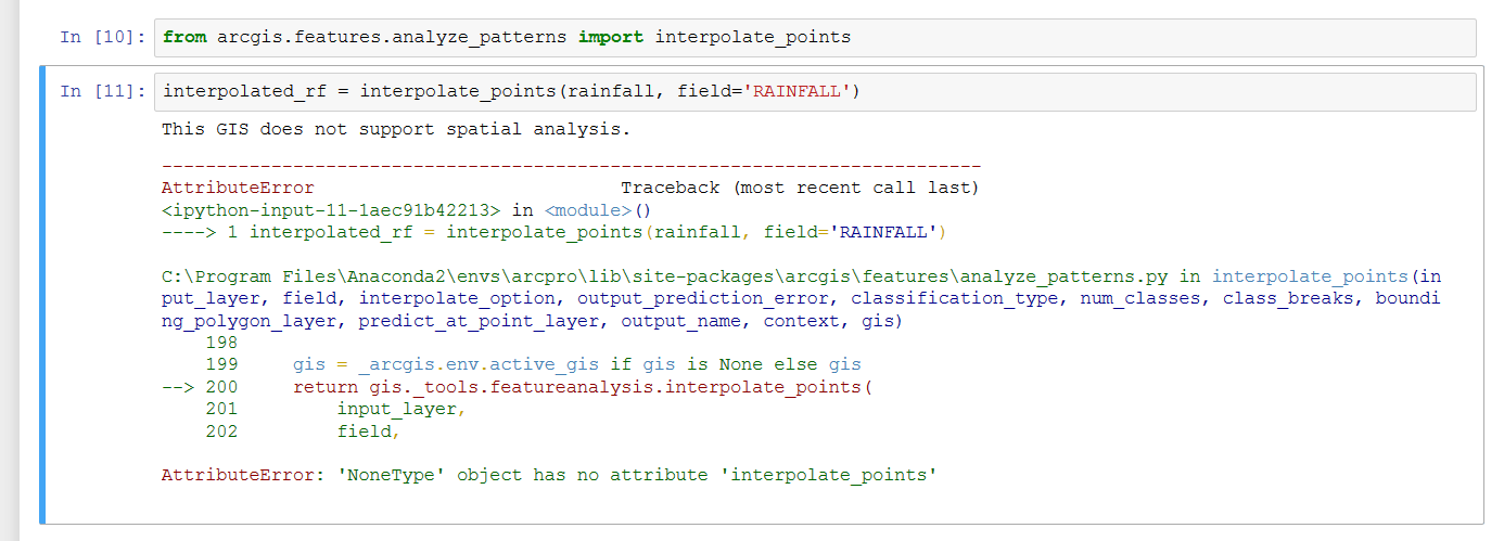
I am logged in with my developer account. I also tried to see if my GIS is supported, by running the command:
arcgis.geoanalytics.is_supported(cont), and the result is False.
Is the error caused by the account type, or by my Python API library installation (arcgis)?
Thanks for any help!
Alin
- Mark as New
- Bookmark
- Subscribe
- Mute
- Subscribe to RSS Feed
- Permalink
- Report Inappropriate Content
Hello Alin,
What GIS are you using to try this out?
If you're using ArcGIS Online org account, the page at Frequently asked questions—ArcGIS Online Help | ArcGIS states that a Level 2 account is required for spatial analysis:
Privileges to use geoenrichment and spatial analysis can be assigned to members with level 2 accounts only.
If you're using a Portal/ArcGIS Enterprise, the interpolate points tool requires spatial analysis to be configured with your Portal, and your account to have privileges to run the spatial analysis tools.
The Configure the portal to perform analysis—Portal for ArcGIS (10.5) | ArcGIS Enterprise page has steps on how to do this:
The spatial analysis tools are hosted as a series of tasks in ArcGIS Server. For members of your organization to use these tasks to perform analysis in Portal for ArcGIS, you'll need to set up a base ArcGIS Enterprise deployment and grant members privileges to perform analysis
Hope this helps,
Rohit
- Mark as New
- Bookmark
- Subscribe
- Mute
- Subscribe to RSS Feed
- Permalink
- Report Inappropriate Content
Hi, and thank you for the reply!
I am using a developer account that has level 2 privileges and 45 available credits. I am not using a Portal/ArcGIS Enterprise account.
Thanks again!
Alin
- Mark as New
- Bookmark
- Subscribe
- Mute
- Subscribe to RSS Feed
- Permalink
- Report Inappropriate Content
Can you query the following:
gis.properties.helperServices.analysis
I created a free developer account and I see that it includes the analysis service. The output of the above command with my account is:
{   "url": "https://analysis7.arcgis.com/arcgis/rest/services/tasks/GPServer" }

Thanks,
Rohit