ArcGIS API for Python Blog

cancel
Showing results for 
Show  only  | Search instead for 
Did you mean: 

Other Boards in This Place

Latest Activity

(28 Posts)
ShareUser
Esri Community Manager

Yes, the whole internet, in either direction, with optional analysis on the way.  What's not to like?

Read more...

more
0 1 279
Clubdebambos
Occasional Contributor III

Data can often be provided as a Shapefile with an accompanying file containing the attribute information, or surplus attributes to compliment those in the Shapefile, such as a CSV for example. The ArcGIS API for Python provides no method to add a Shapefile and CSV together in a zipped folder, and publish as a Hosted Service containing a Feature Layer and a Table. These have to be added and published separately. This Blog post will take a published Table and add as a Table to a Feature Service containing a Feature Layer. A relationship will be created between the Feature Layer and the Table. While this can be achieved by publishing via ArcGIS Pro, here, we will use the ArcGIS API for Python only. 

Read more...

more
14 3 2,604
MehdiPira1
Esri Contributor

Introduction

Smartsheet is a dynamic workspace that empowers teams to manage projects, automate workflows, and rapidly build new solutions. Smartsheet uses spreadsheets, referred to as sheets, as the basis of everything it does, but the difference between Smartsheet and spreadsheet programs like Microsoft Excel or Google Sheets is that Smartsheet has all sorts of collaboration functionality incorporated into it.

Read more...

more
13 5 4,382
AndresCastillo
MVP Regular Contributor

snippets to manage a web map with the ArcGIS API for Python

Read more...

more
1 6 1,984
AndresCastillo
MVP Regular Contributor

ArcGIS API for python User.items() method says it takes dictionary from the folders property, but the folders property says it returns a list:
 
AndresCastillo_0-1617215088337.png


AndresCastillo_1-1617215096675.png


the folders property actually returns a list of dictionaries:
 
 
AndresCastillo_2-1617215109102.png

more
0 0 1,039
IhabHassan
Esri Contributor

Recently I came across ESRI web course Update Real-Time Data with Python, and it walks through a tutorial on how to built what is called "feed routine". The idea is basically is to read latest version of certain feature-set from a JSON file shared and accessed through a URL, and feed that into your system, which in this case is a hosted feature layer. 

In this blog, I wanted to focus on the function "deployLogic" which takes places after reading the latest JSON data and converting it to ESRI file-geodatabase. This function demonstrate really important workflow on how to update the data of hosted feature layer, while keeping the hosted layer item id - as a Portal for ArcGIS or AGOL item. I didn't find similar workflow explained in the published documentation for ArcPy or API for Python, and I believe it can be accommodated to be used with more complex scenarios.

I will try to summarize the function logic in the following bullets:

  • Using 7zip sub-process, extract the hosted layer service definition file
  • Browse to the extracted folder, reach the underlying source file gdb, and delete it
  • Copy the fresh file-geodatabase that was created in previous step to the extracted service definition folder
  • Using 7zip, compress the service definition folder into a new service definition file with '.sd' extension, not '.zip'
  • Using "FeatureLayerCollectionManager" instance, update the hosted layer using the new service definition file


The simplicity of this workflow is that it avoids republishing the service using ArcGIS Pro project, so you won't need to go through something like "getWebLayerSharingDraft" from a Map object, and worry about setting the needed flags "overwriteExistingService", etc.. I find this really easy shortcut, and it will get the job done.

Update Real-Time Data with Python

Update Real-Time Data with Python

Update Real-Time Data with Python

more
6 2 1,883
by Anonymous User
Not applicable

Happy Halloween! The ArcGIS API for Python has just released its newest version, 1.7.0. View the release notes here to see what's new and what bugs have been fixed. Visit our landing page for all other information about the Python API.

You can install this newest version via conda:

conda install -c esri arcgis

or pip:

pip install arcgis

We can't wait to hear what you think of this release!

more
4 10 4,526
RobertWeber
New Contributor III

We create tile packages for field workers fairly frequently so they can have additional maps available to them when they go offline in the field.  Typically this process has involved several different tools depending on the particular map or imagery that is needing to be tiled.  Generally, I have found the ManageTileCache and ExportTileCache GP tools to be most reliable.  So recently I started thinking about combining them along with the Python API so we could have one tool to use for publishing TPK's to our AGOL Org. Any feedback or suggestions would be greatly appreciated.

Basic outline of what the tool does:

  1. Make connection and get a token from your portal with whatever credentials are being used in Pro
  2. Take an input raster dataset
  3. Create a new folder for outputs in the same directory as the input dataset
  4. Allow user to name output dataset
  5. Run ManageTileCache tool to create a local tile cache ( by default the entire extent of the input dataset is used and LOD's are created based off of the input data source pixel information)
  6. Run ExportTileCache tool to create local tpk file
  7. Report file size info back via arcpy Messages
  8. Add tpk item to portal
  9. Attempt to publish the tpk as hosted tile layer
    • Publishing a tpk item seemed to need the additional step of making a POST via the REST api to actually unpack and publish the tiles using '/updateTiles' contained in the tpk  this is done using requests.post just simply using publish() with the python api tended to fail at going beyond creating the hosted tile layer.
  10. Uses urllib to get additional info about the hosted tile layer and LOD's being published.

This tool has been handy in certain situations for us and I hope it is for someone else too.  Still I am always interested if someone has a better way of doing this.

more
2 0 2,314
Oliver_Burdekin
Occasional Contributor II

For anyone interested in GIS development and Python I've put together a tutorial on using esri's ArcGIS Python API in Jupyter Notebooks.

ArcGIS Python API in Jupyter Notebooks | burdGIS - YouTube 

#gis #python #esri #arcgis #tutorial #jupyter

more
3 0 1,167
EarlMedina
Esri Regular Contributor

Quite often, people wonder how to use the ArcGIS API for Python to update layer symbology. After a quick search through posts and documentation, one may discover that there are a number of ways to accomplish this and find oneself uncertain of how to proceed. If you land on this page my hope is that everything will start to make a bit more sense. In this post I'll go over:

  1. How to update layer symbology in a Web Map
  2. How to update layer symbology on a layer item
  3. How to update symbology on a Feature Service Layer

If the above all seem the same don't worry - presently, the distinctions between #1, #2, and #3 will become clear and you will get a better sense of when you might want to choose one method over another.

Note: Although I'm illustrating how to update symbology, you can apply the same concepts to update/configure other properties such as pop-ups, labels, etc. I encourage you to build upon the below standalone scripts or use only the parts you need!

How to Update Layer Symbology in a Web Map:

Let's suppose you add this Map Service to your content in ArcGIS Online/Portal for ArcGIS: https://sampleserver6.arcgisonline.com/arcgis/rest/services/USA/MapServer

You add the item to a Web Map and for a little while it suits your needs:
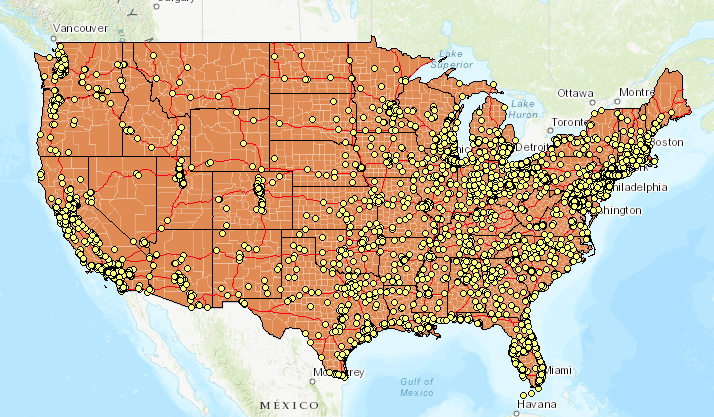
initial_webmap

But one day you decide that you don't really like the color orange and would get more use out of the Web Map if you could better visualize total population of each county.

After some time, you settle on the symbology included in the attached webmaplyr.json. It's a bit a long so I won't include it here - this is fine because you probably won't want to define the JSON in your script anyway, preferring to read from a file.

Note:

If you don't know where to get started as far as generating your own JSON don't fret. Simply start by creating a Web Map exactly as you want it to appear (apply styles, labels, options, etc.). From there, you can go to (where itemID is the item id of the Web Map):

Alternatively, you can get the JSON using the ArcGIS API for Python with a few lines:

from arcgis import GIS
import json

conn = GIS("https://machine.domain.com/portal", "admin", "password")
item = conn.content.get(<itemID>)
item_data = item.get_data()
# Include the below line for prettified JSON
print(json.dumps(item_data, indent=4, sort_keys=True))
‍‍‍‍‍‍‍‍‍‍‍‍‍‍‍‍‍‍‍‍‍‍‍‍‍‍‍‍‍‍‍‍‍‍‍‍‍‍‍‍‍‍‍‍‍‍‍‍‍‍‍‍‍‍‍‍‍‍‍‍‍‍‍‍‍‍‍‍‍‍‍‍‍‍‍‍‍‍‍‍‍‍‍‍‍‍‍‍‍‍‍‍‍‍‍‍‍‍‍‍‍‍‍‍‍‍‍‍‍‍‍‍‍‍‍‍‍‍‍‍‍‍‍‍‍‍‍‍‍‍‍‍‍‍‍‍‍‍‍‍‍‍‍‍‍‍‍‍

The below script illustrates how to read your prepared JSON from a file and apply it to the Web Map:

from arcgis import GIS
import json, sys

def search_item(conn,layer_name):
    search_results = conn.content.search(layer_name, item_type='Web Map')
    proper_index = [i for i, s in enumerate(search_results) if 
                    '"'+layer_name+'"' in str(s)]
    found_item = search_results[proper_index[0]]
    get_item = conn.content.get(found_item.id)
    return get_item

def update_wm_layerdef(item):
    item_data = item.get_data()

    print("*******************ORIGINAL DEFINITION*********************")
    print(json.dumps(item_data, indent=4, sort_keys=True))
    # Open JSON file containing symbology update
    with open('/path/to/webmaplyr.json') as json_data:
        data = json.load(json_data)

    # Set the item_properties to include the desired update
    item_properties = {"text": json.dumps(data)}

    # 'Commit' the updates to the Item
    item.update(item_properties=item_properties)

    # Print item_data to see that changes are reflected
    new_item_data = item.get_data()
    print("***********************NEW DEFINITION**********************")
    print(json.dumps(new_item_data, indent=4, sort_keys=True))

def main():
    conn = GIS("https://machine.domain.com/portal", 
               "admin", "password")
    
    # Search for item, get item data)
    item = search_item(conn, 'wm_lyrsym')
    update_wm_layerdef(item)

if __name__ == '__main__':
    sys.exit(main())
‍‍‍‍‍‍‍‍‍‍‍‍‍‍‍‍‍‍‍‍‍‍‍‍‍‍‍‍‍‍‍‍‍‍‍‍‍‍‍‍‍‍‍‍‍‍‍‍‍‍‍‍‍‍‍‍‍‍‍‍‍‍‍‍‍‍‍‍‍‍‍‍‍‍‍‍‍‍‍‍‍‍‍‍‍‍‍‍‍‍‍‍‍‍‍‍‍‍‍‍‍‍‍‍‍‍‍‍‍‍‍‍‍‍‍‍‍‍‍‍‍‍‍‍‍‍‍‍‍‍‍‍‍‍‍‍‍‍‍‍‍‍‍‍‍‍‍‍‍‍‍‍‍‍‍‍‍‍‍‍‍‍‍‍‍‍‍‍‍‍‍‍‍‍‍‍‍‍‍‍‍‍‍‍‍‍‍‍‍‍‍‍‍‍‍‍‍‍‍‍‍‍‍‍‍‍‍‍‍‍‍‍‍‍‍‍‍‍‍‍‍‍‍‍‍‍‍‍‍‍‍‍‍‍‍‍‍‍‍‍‍‍‍‍‍‍‍‍‍‍‍‍‍‍‍‍‍‍‍‍‍‍‍‍‍‍‍‍‍‍‍‍‍‍‍‍‍‍‍‍‍‍‍‍‍‍‍‍‍‍‍‍‍‍‍‍‍‍‍‍‍‍‍‍‍‍‍‍‍‍‍‍‍‍‍‍‍‍‍‍‍‍‍‍‍‍‍‍‍‍‍‍‍‍‍‍‍‍‍‍‍‍‍‍‍‍‍‍‍‍‍‍‍‍‍‍‍‍‍‍‍‍‍‍‍‍‍‍‍‍‍‍‍‍‍‍‍‍‍‍‍‍‍‍‍‍‍‍‍‍‍‍‍‍‍‍‍‍‍‍‍‍‍‍‍‍‍‍‍‍‍‍‍‍‍‍‍‍‍‍‍‍‍‍‍‍‍‍‍‍‍‍‍‍‍‍‍‍‍‍‍‍‍‍‍‍‍‍‍‍‍‍‍‍‍‍‍‍‍‍‍‍‍‍‍‍‍‍‍‍‍‍‍‍‍‍‍‍‍‍‍‍‍‍‍‍‍‍‍‍‍‍‍‍‍‍‍‍‍‍‍‍‍‍‍‍‍‍‍‍‍‍‍‍‍‍‍‍‍‍‍‍‍‍‍‍‍‍‍‍‍‍‍‍‍‍‍‍‍‍‍‍‍‍‍‍‍‍‍‍‍‍‍‍‍‍‍‍‍‍‍‍‍‍‍‍‍‍‍‍‍‍‍‍‍‍‍‍‍‍‍‍‍‍‍‍‍‍‍‍‍‍‍‍‍‍‍‍‍‍‍‍‍‍‍‍‍‍‍‍‍‍‍‍‍‍‍‍‍‍‍‍‍‍‍‍‍‍‍‍‍‍‍‍‍‍‍‍‍‍‍‍‍‍‍‍‍‍‍‍‍‍‍‍‍‍‍‍‍‍‍‍‍‍‍‍‍‍‍‍‍‍‍‍‍‍‍‍‍‍‍‍‍‍‍‍‍‍

After the script runs, you end up with the below:
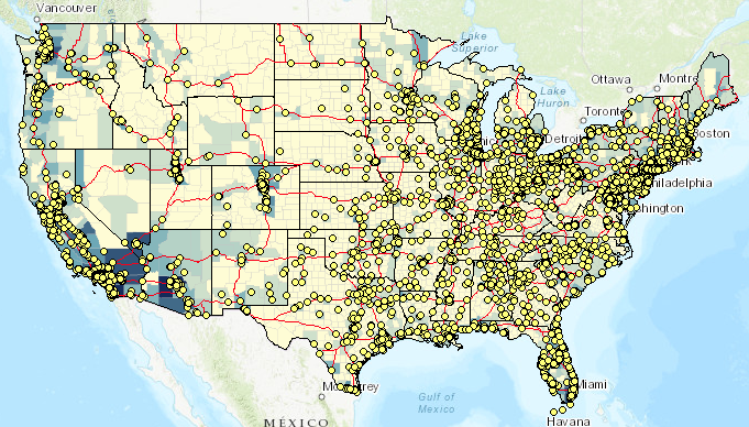
updated web map

How to Update Portal/ArcGIS Online Item Symbology:

The difference here is subtle. In Option #1, the item being updated is a Web Map. Here, the item being updated is a Feature/Map Image Service Layer. The service might be something you published to ArcGIS Online/Portal for ArcGIS, or a Map/Feature Service you added as an item to your content.

Option #1 is great if all you need to do is change the styles in a Web Map, but perhaps you need to change the style for an item in your Organization. Since this item is used by many people (and deliverables are occasionally provided to stakeholders outside of the organization) you wish to standardize its appearance.

In this example, I use the same Map Service as before (https://sampleserver6.arcgisonline.com/arcgis/rest/services/USA/MapServer) and perform a similar update to the symbology, only on the Layer item itself.

Note that this example is a bit more specific on how the symbology is updated:

layer_def = item_data['layers'][3]['layerDefinition']‍

  • Here you see that only the layer at index 3 is updated (counties) - everything else in the service is left alone.
  •  Review drawingInfo.json and you can see that the renderer is updated from Single symbol to Classified.

You might wonder why this is included:

    else:
        print("There is no Layer Definition at the moment..creating one...")
        create_layer_def(item)‍‍‍

  • A layer definition isn't necessarily created by default. Let's suppose I only just added that Map Service as an item to my content - that ArcGIS Online/Portal for ArcGIS item has no layer definition attached it.
    • If added the item to a Web Map, made a simple symbology change, and saved the layer this would generate an layer definition.
    • complete.json contains the layer definitions that would apply to the entire item (all 4 layers).

from arcgis import GIS
import json, sys

def search_layer(conn,layer_name):
    search_results = conn.content.search(layer_name, item_type='*')
    proper_index = [i for i, s in enumerate(search_results) if 
                    '"'+layer_name+'"' in str(s)]
    found_item = search_results[proper_index[0]]
    get_item = conn.content.get(found_item.id)
    return get_item

def update_layer_def(item):
    item_data = item.get_data()
    if item_data is not None:
        # Here note we are changing a specific part of the Layer Definition
        layer_def = item_data['layers'][3]['layerDefinition']
        print("*******************ORIGINAL DEFINITION*********************")
        print(json.dumps(item_data, indent=4, sort_keys=True))

        # Open JSON file containing symbology update
        with open('/path/to/drawingInfo.json') as json_data:
            data = json.load(json_data)

        # Set the drawingInfo equal to what is in JSON file
        layer_def['drawingInfo'] = data

        # Set the item_properties to include the desired update
        item_properties = {"text": json.dumps(item_data)}

        # 'Commit' the updates to the Item
        item.update(item_properties=item_properties)

        # Print item_data to see that changes are reflected
        new_item_data = item.get_data()
        print("***********************NEW DEFINITION**********************")
        print(json.dumps(new_item_data, indent=4, sort_keys=True))
    
    else:
        print("There is no Layer Definition at the moment..creating one...")
        create_layer_def(item)

def create_layer_def(item):   
    with open('/path/to/complete.json') as json_data:
        data = json.load(json_data)

    # Set the item_properties to include the desired update
    item_properties = {"text": json.dumps(data)}

    # 'Commit' the updates to the Item
    item.update(item_properties=item_properties)

    # Print item_data to see that changes are reflected
    item_data = item.get_data()
    print("*********************CREATED DEFINITION************************")
    print(json.dumps(item_data, indent=4, sort_keys=True))   
    
def main():
    conn = GIS("https://machine.domain.com/portal", 
               "admin", "password")
    
    # Search for item, get item data)
    item = search_layer(conn, 'earl_api_usalyraw')
    # Attempt to update Layer Definition
    update_layer_def(item)

if __name__ == '__main__':
    sys.exit(main())‍‍‍‍‍‍‍‍‍‍‍‍‍‍‍‍‍‍‍‍‍‍‍‍‍‍‍‍‍‍‍‍‍‍‍‍‍‍‍‍‍‍‍‍‍‍‍‍‍‍‍‍‍‍‍‍‍‍‍‍‍‍‍‍‍‍‍‍‍‍‍‍‍‍‍‍‍‍‍‍‍‍‍‍‍‍‍‍‍‍‍‍‍‍‍‍‍‍‍‍‍‍‍‍‍‍‍‍‍‍‍‍‍‍‍‍‍‍‍‍‍‍‍‍‍‍‍‍‍‍‍‍‍‍‍‍‍‍‍‍‍‍‍‍‍‍‍‍‍‍‍‍‍‍‍‍‍‍‍‍‍‍‍‍‍‍‍‍‍‍‍‍‍‍‍‍‍‍‍‍‍‍‍‍‍‍‍‍‍‍‍‍‍‍‍‍‍‍‍‍‍‍‍‍‍‍‍‍‍‍‍‍‍‍‍‍‍‍‍‍‍‍‍‍‍‍‍‍‍‍‍‍‍‍‍‍‍‍‍‍‍‍‍‍‍‍‍‍‍‍‍‍‍‍‍‍‍‍‍‍‍‍‍‍‍‍‍‍‍‍‍‍‍‍‍‍‍‍‍‍‍‍‍‍‍‍‍‍‍‍‍‍‍‍‍‍‍‍‍‍‍‍‍‍‍‍‍‍‍‍‍‍‍‍‍‍‍‍‍‍‍‍‍‍‍‍‍‍‍‍‍‍‍‍‍‍‍‍‍‍‍‍‍‍‍‍‍‍‍‍‍‍‍‍‍‍‍‍‍‍‍‍‍‍‍‍‍‍‍‍‍‍‍‍‍‍‍‍‍‍‍‍‍‍‍‍‍‍‍‍‍‍‍‍‍‍‍‍‍‍‍‍‍‍‍‍‍‍‍‍‍‍‍‍‍‍‍‍‍‍‍‍‍‍‍‍‍‍‍‍‍‍‍‍‍‍‍‍‍‍‍‍‍‍‍‍‍‍‍‍‍‍‍‍‍‍‍‍‍‍‍‍‍‍‍‍‍‍‍‍‍‍‍‍‍‍‍‍‍‍‍‍‍‍‍‍‍‍‍‍‍‍‍‍‍‍‍‍‍‍‍‍‍‍‍‍‍‍‍‍‍‍‍‍‍‍‍‍‍‍‍‍‍‍‍‍‍‍‍‍‍‍‍‍‍‍‍‍‍‍‍‍‍‍‍‍‍‍‍‍‍‍‍‍‍‍‍‍‍‍‍‍‍‍‍‍‍‍‍‍‍‍‍‍‍‍‍‍‍‍‍‍‍‍‍‍‍‍‍‍‍‍‍‍‍‍‍‍‍‍‍‍‍‍‍‍‍‍‍‍‍‍‍‍‍‍‍‍‍‍‍‍‍‍‍‍‍‍‍‍‍‍‍‍‍‍‍‍‍‍‍‍‍‍‍‍‍‍‍‍‍‍‍‍‍‍‍‍‍‍‍‍‍‍‍‍‍‍‍‍‍‍‍‍‍‍‍‍‍‍‍‍‍‍‍‍‍‍‍‍‍‍‍‍‍‍‍‍‍‍‍‍‍‍‍‍‍‍‍‍‍‍‍‍‍‍‍‍‍‍‍‍‍‍‍‍‍‍‍‍‍‍‍‍‍‍‍‍‍‍‍‍‍‍‍‍‍‍‍‍‍‍‍‍‍‍‍‍‍‍‍‍‍‍‍‍‍‍‍‍‍‍‍‍‍‍‍‍‍‍‍‍‍‍‍‍‍‍‍‍‍‍‍‍‍‍‍‍‍‍‍‍‍‍‍‍‍‍‍‍‍‍‍‍‍‍‍‍‍‍‍‍‍‍‍‍‍‍‍‍‍‍‍‍‍‍‍‍‍‍‍‍‍‍‍‍‍‍‍‍‍‍‍‍‍‍‍‍‍‍‍‍‍‍‍‍‍‍‍‍‍‍‍‍‍‍‍‍‍‍‍‍‍‍‍‍‍‍‍‍‍‍‍‍‍‍‍‍‍‍‍‍‍‍‍‍‍‍‍‍‍‍‍‍‍‍‍‍‍‍‍‍‍‍‍‍‍‍‍‍‍‍‍‍‍‍‍‍‍‍‍‍‍‍‍‍‍‍‍‍‍‍‍‍‍‍‍‍‍‍‍‍‍‍‍‍‍‍‍‍‍‍‍‍‍‍‍‍‍‍‍‍‍‍‍‍‍‍‍‍‍‍‍‍‍‍‍‍‍‍‍‍‍‍‍‍‍‍‍‍‍‍‍‍‍‍‍‍‍‍‍‍‍‍‍‍‍‍‍‍‍‍‍‍‍‍‍‍‍‍‍‍‍‍‍‍‍‍‍‍‍‍‍‍‍‍‍‍‍‍‍‍‍‍‍‍‍‍‍‍‍‍‍‍‍‍‍‍‍‍‍‍‍‍‍‍‍‍‍‍‍‍‍‍‍‍‍‍‍‍‍‍‍‍‍‍‍‍‍‍‍‍‍‍‍‍‍‍‍‍‍‍‍‍‍‍‍‍‍‍‍‍‍‍‍‍‍‍‍‍‍‍‍‍‍‍‍‍‍‍‍‍‍‍‍‍‍‍‍‍‍‍‍‍‍‍‍‍‍‍‍‍‍‍‍‍‍‍‍‍‍‍‍‍‍‍‍‍‍‍‍‍‍‍‍‍‍‍‍‍‍‍‍‍‍‍‍‍‍‍‍‍‍‍‍‍‍‍‍‍‍‍‍‍‍‍‍‍‍‍‍‍‍‍‍‍‍‍‍‍‍‍‍‍‍‍‍

How to Update Feature Service Symbology:

In this last example, I illustrate how to update symbology on a Feature Service Layer. Behind the scenes, this method really just performs this operation: Update Definition (Feature Layer)—ArcGIS REST API: Services Directory | ArcGIS for Developers 

So, what's the difference here and when would you want to use this approach?

  • This will only work for Feature Services.
  • You would want to use this approach when you want to make high-level updates to your Feature Service Layers. This can be used to standardize the appearance of Feature Service Layers across the board - without making any client-side modifications, someone adding the Feature Service to a ArcGIS Online/Portal for ArcGIS Web Map would see the same thing as a developer consuming the service in an application.

For this example, I published a Hosted Feature Service containing 2 layers:

  1. US States/Canada Provinces
  2. North America Major Railroads

The original Feature Service looks like this:
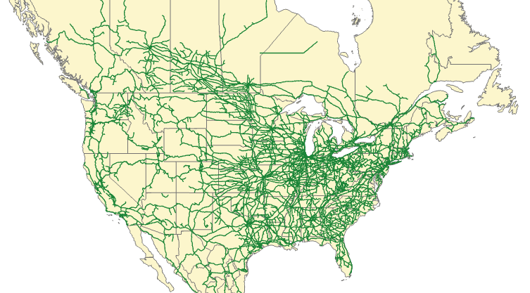
fs-original

The JSON for this example isn't very long. I just make a few changes to color and width on the States/Provinces layer:

{
  "drawingInfo": {
    "renderer": {
      "type": "simple",
      "symbol": {
        "type": "esriSFS",
        "style": "esriSFSSolid",
        "color": [
          202,
          46,
          204,
          105
        ],
        "outline": {
          "type": "esriSLS",
          "style": "esriSLSSolid",
          "color": [
            10,
            10,
            210,
            55
          ],
          "width": 0.5
        }
      }
    },
    "scaleSymbols": true,
    "transparency": 0,
    "labelingInfo": null
  }
}‍‍‍‍‍‍‍‍‍‍‍‍‍‍‍‍‍‍‍‍‍‍‍‍‍‍‍‍‍‍‍‍‍‍‍‍‍‍‍‍‍‍‍‍‍‍‍‍‍‍‍‍‍‍‍‍‍‍‍‍‍‍‍‍‍‍‍‍‍‍‍‍‍‍‍‍‍‍‍‍‍‍‍‍‍‍‍‍‍‍‍‍‍‍‍‍‍‍‍‍‍‍‍‍‍‍‍‍‍‍‍‍‍‍‍‍‍‍‍‍‍‍‍‍‍‍‍‍‍‍‍‍‍‍‍‍‍‍‍‍‍‍‍‍‍‍‍‍‍‍‍‍‍‍‍‍‍‍‍‍‍‍‍‍‍‍‍‍‍‍‍‍‍‍‍‍‍‍‍‍‍‍‍‍‍‍‍‍‍‍‍‍‍‍‍‍‍‍‍‍‍‍‍‍‍‍‍‍‍‍‍‍‍‍‍‍‍‍‍‍‍‍‍‍‍‍‍‍‍‍‍‍‍‍‍‍‍‍‍‍‍‍‍‍‍‍‍‍‍‍‍‍‍‍‍‍‍‍‍‍‍‍‍‍‍‍‍‍‍‍‍‍‍‍‍‍‍‍‍‍‍‍‍‍‍‍‍‍‍‍‍‍‍‍‍‍‍‍‍‍‍‍‍‍‍‍‍‍‍‍‍‍‍‍‍‍‍‍‍‍‍‍‍‍‍‍‍‍‍‍‍‍‍‍‍‍‍‍‍‍‍‍‍‍‍‍‍‍‍‍‍‍‍‍‍‍‍‍‍‍‍‍‍‍‍‍‍‍‍‍‍‍‍‍‍‍‍‍‍‍‍‍‍‍‍‍‍‍‍‍‍‍‍‍‍‍‍‍‍‍‍‍‍‍‍‍‍‍‍‍‍‍‍‍‍‍‍‍‍‍‍‍‍‍‍‍‍‍‍‍‍‍‍‍‍‍‍‍‍‍‍‍‍‍‍‍‍‍‍‍‍‍‍‍‍‍‍‍‍‍‍‍‍‍‍‍‍‍‍‍‍‍‍‍‍‍‍‍‍‍‍‍‍‍‍‍‍‍‍‍‍‍‍‍‍‍‍‍‍‍‍‍‍‍‍‍‍‍‍‍‍‍‍‍‍‍‍‍‍‍‍‍‍‍‍‍‍

In this scenario, since we're updating a Feature Service and not an item we need to use arcgis.features.

from arcgis import GIS
from arcgis.features import FeatureLayerCollection
import json, sys


def search_layer(conn,layer_name):
    search_results = conn.content.search(layer_name, item_type='Feature Layer')
    proper_index = [i for i, s in enumerate(search_results) if 
                    '"'+layer_name+'"' in str(s)]
    found_item = search_results[proper_index[0]]
    flc = FeatureLayerCollection.fromitem(found_item)
    return flc


def update_layer_def(layer):
    # Open JSON file containing symbology update
    with open('/path/to/hosted_drawinfo_lyr.json') as json_data:
        data = json.load(json_data)
    
    layer.manager.update_definition(data)
    print("*******************UPDATED DEFINITION**********************")
    print(layer.properties)

    
def main():
    conn = GIS("https://machine.domain.com/portal", 
               "admin", "password")
    
    # Search for item, get item data)
    flc = search_layer(conn, 'layerdef')
    layer = flc.layers[1]
    print(layer.properties)
    update_layer_def(layer)

if __name__ == '__main__':
    sys.exit(main())
‍‍‍‍‍‍‍‍‍‍‍‍‍‍‍‍‍‍‍‍‍‍‍‍‍‍‍‍‍‍‍‍‍‍‍‍‍‍‍‍‍‍‍‍‍‍‍‍‍‍‍‍‍‍‍‍‍‍‍‍‍‍‍‍‍‍‍‍‍‍‍‍‍‍‍‍‍‍‍‍‍‍‍‍‍‍‍‍‍‍‍‍‍‍‍‍‍‍‍‍‍‍‍‍‍‍‍‍‍‍‍‍‍‍‍‍‍‍‍‍‍‍‍‍‍‍‍‍‍‍‍‍‍‍‍‍‍‍‍‍‍‍‍‍‍‍‍‍‍‍‍‍‍‍‍‍‍‍‍‍‍‍‍‍‍‍‍‍‍‍‍‍‍‍‍‍‍‍‍‍‍‍‍‍‍‍‍‍‍‍‍‍‍‍‍‍‍‍‍‍‍‍‍‍‍‍‍‍‍‍‍‍‍‍‍‍‍‍‍‍‍‍‍‍‍‍‍‍‍‍‍‍‍‍‍‍‍‍‍‍‍‍‍‍‍‍‍‍‍‍‍‍‍‍‍‍‍‍‍‍‍‍‍‍‍‍‍‍‍‍‍‍‍‍‍‍‍‍‍‍‍‍‍‍‍‍‍‍‍‍‍‍‍‍‍‍‍‍‍‍‍‍‍‍‍‍‍‍‍‍‍‍‍‍‍‍‍‍‍‍‍‍‍‍‍‍‍‍‍‍‍‍‍‍‍‍‍‍‍‍‍‍‍‍‍‍‍‍‍‍‍‍‍‍‍‍‍‍‍‍‍‍‍‍‍‍‍‍‍‍‍‍‍‍‍‍‍‍‍‍‍‍‍‍‍‍‍‍‍‍‍‍‍‍‍‍‍‍‍‍‍‍‍‍‍‍‍‍‍‍‍‍‍‍‍‍‍‍‍‍‍‍‍‍‍‍‍‍‍‍‍‍‍‍‍‍‍‍‍‍‍‍‍‍‍‍‍‍‍‍‍‍‍‍‍‍‍‍‍‍‍‍‍‍‍‍‍‍‍‍‍‍‍‍‍‍‍‍‍‍‍‍‍‍‍‍‍‍‍‍‍‍‍‍‍‍‍‍‍‍‍‍‍‍‍‍‍‍‍‍‍‍‍‍‍‍‍‍‍‍‍‍‍‍‍‍‍‍‍‍‍‍‍‍‍‍‍‍‍‍‍‍‍‍‍‍‍‍‍‍‍‍‍‍‍‍‍‍‍‍‍‍‍‍‍‍‍‍‍
  • The States/Provinces layer was at index 1.

The update result:
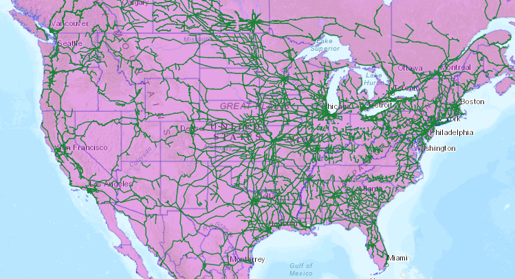
fs-update

That concludes this overview on how to update layer symbology. Hopefully with this guide you can get a good sense of how to implement similar workflows in your organization!

more
15 14 15K
182 Subscribers