- Home
- :
- All Communities
- :
- Developers
- :
- JavaScript Maps SDK
- :
- JavaScript Maps SDK Questions
- :
- Re: Viewshed observer Height
- Subscribe to RSS Feed
- Mark Topic as New
- Mark Topic as Read
- Float this Topic for Current User
- Bookmark
- Subscribe
- Mute
- Printer Friendly Page
- Mark as New
- Bookmark
- Subscribe
- Mute
- Subscribe to RSS Feed
- Permalink
- Report Inappropriate Content
Using this: CreateViewshed | API Reference | ArcGIS API for JavaScript 3.23
I think I am defining the parameters for Height incorrectly and cant seem to find them in the documentation
vsHeight.height
"observerHeight": vsHeight,
"observerHeightUnits": "feet"
Trying this:
<input type="radio" name="DistanceVS" value="1" checked="checked">1 Mile</input>
<input type="radio" name="HeightVS" value="1" checked="checked">1 Meter</input>
var radios = document.getElementsByName('DistanceVS');
var w = parseInt(radios);
vsDistance.distance = (w);
var height = document.getElementsByName('HeightVS');
var h = parseInt(height);
vsHeight.height = (h);
vsDistance.units = "esriMiles";
var params = {
"Input_Observation_Point": featureSet,
"Viewshed_Distance": vsDistance,
"observerHeight": vsHeight,
"observerHeightUnits": "feet"
};Solved! Go to Solution.
Accepted Solutions
- Mark as New
- Bookmark
- Subscribe
- Mute
- Subscribe to RSS Feed
- Permalink
- Report Inappropriate Content
Jay,
So if you are trying to get the value of a selected radio in a group of radios then this is what you need:
HTML
<div>
<input type="radio" name="DistanceVS" value="1" checked="checked">1 Mile</input>
<input type="radio" name="DistanceVS" value="3">3 Miles</input>
<input type="radio" name="DistanceVS" value="5">5 Miles</input>
<input type="radio" name="DistanceVS" value="10">10 Miles</input>
</div>
<div>
<div>
<input type="radio" name="HeightVS" value="1" checked="checked">1 Meter</input>
<input type="radio" name="HeightVS" value="3">3 Meters</input>
<input type="radio" name="HeightVS" value="5">5 Meters</input>
<input type="radio" name="HeightVS" value="10">10 Meters</input>
</div>
</div>JS
function computeViewShed(evt) {
map.graphics.clear();
var pointSymbol = new SimpleMarkerSymbol();
pointSymbol.setSize(14);
pointSymbol.setOutline(new SimpleLineSymbol(SimpleLineSymbol.STYLE_SOLID, new Color([255, 0, 0]), 1));
pointSymbol.setColor(new Color([0, 255, 0, 0.25]));
var graphic = new Graphic(evt.mapPoint, pointSymbol);
map.graphics.add(graphic);
var features = [];
features.push(graphic);
var featureSet = new FeatureSet();
featureSet.features = features;
var vsDistance = new LinearUnit();
vsDistance.units = "esriMiles";
var vsHeight = new LinearUnit();
vsHeight.units = "esriMeters";
var distInt, i;
var distVS = document.getElementsByName('DistanceVS');
for (i = 0; i < distVS.length; ++i) {
if (distVS[i].checked) {
distInt= parseInt(distVS[i].value);
}
}
alert(distInt);
vsDistance.distance = (distInt);
var heightInt;
var heightVS = document.getElementsByName('HeightVS');
for (i = 0; i < heightVS.length; ++i) {
if (heightVS[i].checked) {
heightInt= parseInt(heightVS.value);
}
}
alert(heightInt);
vsHeight.distance = (heightInt);
vsDistance.units = "esriMiles";
vsHeight.units = "esriMeters";
var params = {
"Input_Observation_Point": featureSet,
"Viewshed_Distance": vsDistance,
"observerHeight": vsHeight
};
gp.execute(params, drawViewshed, errorViewShed);
}
- Mark as New
- Bookmark
- Subscribe
- Mute
- Subscribe to RSS Feed
- Permalink
- Report Inappropriate Content
I think I got it working....Can someone pass their eyes over this and see if they see anything out of place...
//SNIP
var vsDistance = new LinearUnit();
var vsHeight = new LinearUnit();
var radiodistance = document.getElementsByName('DistanceVS');
var w = parseInt(radiodistance);
vsDistance.distance = (w);
var radioheight = document.getElementsByName('HeightVS');
var h = parseInt(radioheight);
vsHeight.distance = (h);
vsDistance.units = "esriMiles";
vsHeight.units = "esrifeet";
var params = {
"Input_Observation_Point": featureSet,
"Viewshed_Distance": vsDistance,
"observerHeight": vsHeight
};
gp.execute(params, drawViewshed, errorViewShed);
}- Mark as New
- Bookmark
- Subscribe
- Mute
- Subscribe to RSS Feed
- Permalink
- Report Inappropriate Content
No I dont think I have it...seems that the user defined input is not being used in the Viewshed.
I changed them and ran from the same point and get the same result no mater what distance I choose or what height I try and push to the variables. hmmmm
Doesnt seem like I am getting the value of the radio buttons to the variable and then to the Params
- Mark as New
- Bookmark
- Subscribe
- Mute
- Subscribe to RSS Feed
- Permalink
- Report Inappropriate Content
Looks good to me.
- Mark as New
- Bookmark
- Subscribe
- Mute
- Subscribe to RSS Feed
- Permalink
- Report Inappropriate Content
If I add an alert on the
var radiodistance = document.getElementsByName('DistanceVS');
var w = parseInt(radiodistance);
alert(w);
I get

- Mark as New
- Bookmark
- Subscribe
- Mute
- Subscribe to RSS Feed
- Permalink
- Report Inappropriate Content
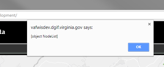
If I alert here
var radiodistance = document.getElementsByName('DistanceVS');
alert(radiodistance);
if gives me:
- Mark as New
- Bookmark
- Subscribe
- Mute
- Subscribe to RSS Feed
- Permalink
- Report Inappropriate Content
Jay,
So the issue is you are returning the dom element and not the value:
var height = document.getElementsByName('HeightVS').value;- Mark as New
- Bookmark
- Subscribe
- Mute
- Subscribe to RSS Feed
- Permalink
- Report Inappropriate Content
I get the below response for each of the alerts below.
undefined
NaN
var radiodistance = document.getElementsByName('DistanceVS').value;
alert(radiodistance);
var w = parseInt(radiodistance);
alert(w);
vsDistance.distance = (w);
- Mark as New
- Bookmark
- Subscribe
- Mute
- Subscribe to RSS Feed
- Permalink
- Report Inappropriate Content
Jay,
Well I really needed to look over your code better... You are using
var radiodistance = document.getElementsByName('DistanceVS')
document.getElementsByName returns an array/collection of node that have that name. You can use this but the more standard way is to give you dom elements an id and then use document.getElementById('DistanceVS').value.
<input type="radio" id="DistanceVS" value="1" checked="checked">1 Mile</input>
<input type="radio" id="HeightVS" value="1" checked="checked">1 Meter</input>
var radios = dom.byId('DistanceVS').value;
var w = parseInt(radios);
vsDistance.distance = (w);
var height = dom.byId('HeightVS').value;
var h = parseInt(height);
vsHeight.height = (h);
vsDistance.units = "esriMiles";
var params = {
"Input_Observation_Point": featureSet,
"Viewshed_Distance": vsDistance,
"observerHeight": vsHeight,
"observerHeightUnits": "feet"
};- Mark as New
- Bookmark
- Subscribe
- Mute
- Subscribe to RSS Feed
- Permalink
- Report Inappropriate Content
- I am trying to give the user a selection of radio buttons to choose the distsance
- Grab that value in JS and write it to a variable
- Use that variable in as a parameter for Viewshed Distance and Viewshed Observer Height
Not sure why I cant get the radio button variable. Not sure if I use ID or NAME...I dont think I can use ID with a radio button selection
<div>
<input type="radio" id="DistanceVS" name="DistanceVS" value="1" checked="checked">1 Mile</input>
<input type="radio" id="DistanceVS" name="DistanceVS" value="3" >3 Miles</input>
<input type="radio" id="DistanceVS" name="DistanceVS" value="5" >5 Miles</input>
<input type="radio" id="DistanceVS" name="DistanceVS" value="10" >10 Miles</input>
</div>
<div>
<div>
<input type="radio" name="HeightVS" value="1" checked="checked">1 Meter</input>
<input type="radio" name="HeightVS" value="3" >3 Meters</input>
</div>
<div>
<input type="radio" name="HeightVS" value="5" >5 Meters</input>
<input type="radio" name="HeightVS" value="10" >10 Meters</input>
</div>
</div>
function computeViewShed(evt) {
map.graphics.clear();
var pointSymbol = new SimpleMarkerSymbol();
pointSymbol.setSize(14);
pointSymbol.setOutline(new SimpleLineSymbol(SimpleLineSymbol.STYLE_SOLID, new Color([255, 0, 0]), 1));
pointSymbol.setColor(new Color([0, 255, 0, 0.25]));
var graphic = new Graphic(evt.mapPoint, pointSymbol);
map.graphics.add(graphic);
var features = [];
features.push(graphic);
var featureSet = new FeatureSet();
featureSet.features = features;
var vsDistance = new LinearUnit();
var vsHeight = new LinearUnit();
// TRYING TO GRAB THE VALUE AND ASSIGN TO VARIABLE AND ALERT
var radiodistance = document.getElementsByName('DistanceVS').value;
// OR
var radiodistance = dom.byId('DistanceVS').value;
alert(radiodistance);
var w = parseInt(radiodistance);
alert(w);
vsDistance.distance = (w);
// SAME AS THE ABOVE DISTANCE VARIABLE
var radioheight = document.getElementsByName('HeightVS').value;
var h = parseInt(radioheight);
vsHeight.distance = (h);
vsDistance.units = "esriMiles";
vsHeight.units = "esriMeters";
var params = {
"Input_Observation_Point": featureSet,
"Viewshed_Distance": vsDistance,
"observerHeight": vsHeight
};
gp.execute(params, drawViewshed, errorViewShed);
}