Turn on suggestions
Auto-suggest helps you quickly narrow down your search results by suggesting possible matches as you type.
Cancel
- Home
- :
- All Communities
- :
- Developers
- :
- JavaScript Maps SDK
- :
- JavaScript Maps SDK Questions
- :
- Re: Query & QueryTask with a feature layer not sho...
Options
- Subscribe to RSS Feed
- Mark Topic as New
- Mark Topic as Read
- Float this Topic for Current User
- Bookmark
- Subscribe
- Mute
- Printer Friendly Page
Query & QueryTask with a feature layer not shown until Query Task executed
Subscribe
03-06-2014
11:52 AM
- Mark as New
- Bookmark
- Subscribe
- Mute
- Subscribe to RSS Feed
- Permalink
- Report Inappropriate Content
I am trying to query a feature layer that is not shown on the map until the query is actually executed. I have a button that I am using to set off the query when it is clicked. Here is the code that I am trying to use:
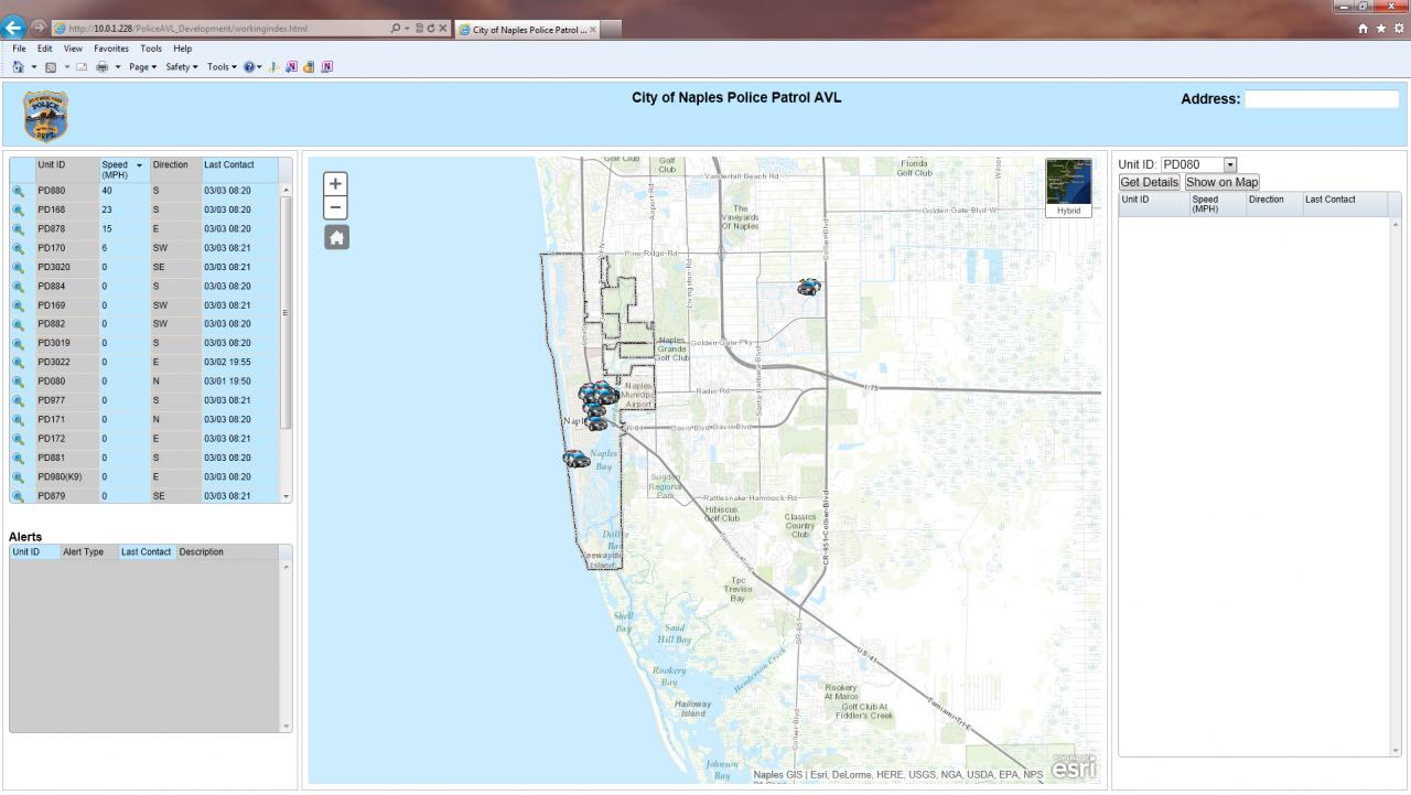
The feature layer is already included in the webpage in on demand mode. What I am trying to do is query the layer so that the only items that show up from that layer are the items from one specific unit id. This is to show the history of one specific vehicle over time. Eventually we would also want to query the time so that the user can specify a certain time and date to get the historical information for one specific vehicle. I am posting a photo of the viewer.
[ATTACH=CONFIG]31992[/ATTACH]
The dropdown menu in the right panel has the unit id's for all police vehicles. What I want is for the historical data (in the historical feature layer) to be shown for whatever specific unit id is selected when I click on the show on map button.
I am fairly new to coding with esri, so any help is appreciated.
on(dom.byId("mapshow"), "click", selectHistorical); function selectHistorical(){ var queryTask = new QueryTask(window.historicalUrl); var query = new Query(); query.returnGeometry=true; query.outFields=window.historicalOutFields; query.text = dom.byId("mydropdown").value; query.outSpatialReference = {"wkid":2236}; dojo.connect(queryTask, "onComplete", function(featureSet){ map.graphics.clear(); dojo.forEach(featureSet.features, function(feature){ var graphic = feature; map.graphics.add(graphic); }); }); queryTask.execute(query); }The feature layer is already included in the webpage in on demand mode. What I am trying to do is query the layer so that the only items that show up from that layer are the items from one specific unit id. This is to show the history of one specific vehicle over time. Eventually we would also want to query the time so that the user can specify a certain time and date to get the historical information for one specific vehicle. I am posting a photo of the viewer.
[ATTACH=CONFIG]31992[/ATTACH]
The dropdown menu in the right panel has the unit id's for all police vehicles. What I want is for the historical data (in the historical feature layer) to be shown for whatever specific unit id is selected when I click on the show on map button.
I am fairly new to coding with esri, so any help is appreciated.
Solved! Go to Solution.
1 Solution
Accepted Solutions
03-10-2014
04:31 AM
- Mark as New
- Bookmark
- Subscribe
- Mute
- Subscribe to RSS Feed
- Permalink
- Report Inappropriate Content
I was having trouble getting this to work with the wkid 2236, but was able to get it to work using a the geographic coordinate system 4326. Here was the function I used:
You will need to add the following modules:
SpatialReference, Point, SimpleMarkerSymbol, SimpleLineSymbol, and Graphic
function selectHistorical() { var queryTask = new QueryTask(window.historicalUrl); var query = new Query(); query.returnGeometry = true; query.outFields = window.historicalOutFields; query.where = "DeviceId = '" + dom.byId("mydropdown").value + "'"; query.outSpatialReference = { "wkid": 4326 }; dojo.connect(queryTask, "onComplete", function (featureSet) { map.graphics.clear(); dojo.forEach(featureSet.features, function (feature) { var point = new Point(feature.geometry.x, feature.geometry.y, new SpatialReference({wkid:4326})); var simpleMarkerSymbol = new SimpleMarkerSymbol(SimpleMarkerSymbol.STYLE_SQUARE, 10, new SimpleLineSymbol(SimpleLineSymbol.STYLE_SOLID, new Color([0,255,0,0.25]), 1), new Color([255,0,0]) ) var graphic = new Graphic(point, simpleMarkerSymbol); map.graphics.add(graphic); }); }); queryTask.execute(query); }You will need to add the following modules:
SpatialReference, Point, SimpleMarkerSymbol, SimpleLineSymbol, and Graphic
15 Replies
03-07-2014
12:39 AM
- Mark as New
- Bookmark
- Subscribe
- Mute
- Subscribe to RSS Feed
- Permalink
- Report Inappropriate Content
Hi
Looks like your query is correct and i presume you can see the query execute if you use firebug or similar?
try the below, you need to take the results and do something with them. I pass it to the showResults function, build a table and zoom to the location on the map.
Looks like your query is correct and i presume you can see the query execute if you use firebug or similar?
try the below, you need to take the results and do something with them. I pass it to the showResults function, build a table and zoom to the location on the map.
//execute query
          queryTask.execute(query0, showResults);
        };

        function showResults(results) {
          var s = "<table>";
          var aliases = results.fieldAliases;
          var len = results.features.length;
          var fieldTypes = {};
          //var dateI = results.fields.length;

           // define a variable that will hold the field type for each field name.
            array.forEach(results.fields, function (aField) {
            fieldTypes[aField.name] = aField.type;
          });

            if (len === 0) { // if no results
             s = "No results for IPMS reference: " + IPMSREF
            } else { // if 1 or more results, display them
             for (var i = 0; i < len; i++) {
              var featureAttributes = results.features.attributes;
                for (var att in featureAttributes) {
                 //var aliasesFix = aliases[att].replace("*", "")
                  if (featureAttributes[att] == null) {
                   featureAttributes[att] = ""
              }
              else if (fieldTypes[att] == "esriFieldTypeDate") {
               featureAttributes[att] = formatDate(new Date(featureAttributes[att]));
              }
              else if (fieldTypes[att] == "esriFieldTypeDouble") {
                featureAttributes[att] = Math.round(featureAttributes[att]*10000)/10000
              }
              else if (att == "EDITEDBY" && "CREATEDBY") {
                featureAttributes[att] = featureAttributes[att].replace("IPS$","");
              }

           s = s + "<tr><td><span style='white-space: nowrap'>" + "<b>" + (aliases.hasOwnProperty(att) && aliases[att]) + "</b>" + ": " + "</td><td style='width:100%;'>" + featureAttributes[att] + "</td></tr>";
            }
            s = s + "<tr class='blank_row'><td></td>"
            }
            s = s + "</table><br />";
          };
           dom.byId("info").innerHTML = s;
           dojo.query("#info table tr:nth-child(odd)").addClass("odd");
           dojo.query("#info table tr:nth-child(even)").addClass("even");

           //get x and y from centre of results geometry = true query
           var polyGonGeom = results.features[0].geometry;
           var polyGonExt = polyGonGeom.getExtent();
           map.setExtent(polyGonExt);

           var Polygon = new esri.geometry.Polygon(polyGonGeom, new esri.SpatialReference({
               wkid: 27700
            }));

           console.log(Polygon)

            if (!graphic) {
                  addGraphic(Polygon);
                } else {
                  graphic.setGeometry(Polygon);
              };
        };
        //add graphic to the map
       function addGraphic(Polygon) {
        //parameters for the symbol
        var symbol = new esri.symbol.SimpleFillSymbol(esri.symbol.SimpleFillSymbol.STYLE_SOLID, new esri.symbol.SimpleLineSymbol(esri.symbol.SimpleLineSymbol.STYLE_SOLID, new dojo.Color([49, 101, 156]), 2), new dojo.Color([148, 186, 231, 0.5]));
                // var symbol = new esri.symbol.PictureMarkerSymbol({
                //     "angle": 0,
                //     "xoffset": 0,
                //     "yoffset": 0,
                //     "type": "esriPMS",
                //     "url": "http://static.arcgis.com/images/Symbols/Basic/BlueShinyPin.png",
                //     "contentType": "image/png",
                //     "width": 24,
                //     "height": 24
                // });
                var graphic = new esri.Graphic(Polygon, symbol);
                map.graphics.add(graphic);
        };
03-07-2014
01:56 AM
- Mark as New
- Bookmark
- Subscribe
- Mute
- Subscribe to RSS Feed
- Permalink
- Report Inappropriate Content
Tried:
replace ID with your rest url attribute column name.
Do you get a result with firebug to the call?
query.where = "ID =" dom.byId("mydropdown").value; instead of query.text??replace ID with your rest url attribute column name.
Do you get a result with firebug to the call?
03-07-2014
03:28 AM
- Mark as New
- Bookmark
- Subscribe
- Mute
- Subscribe to RSS Feed
- Permalink
- Report Inappropriate Content
Tried:query.where = "ID =" dom.byId("mydropdown").value;instead of query.text??
replace ID with your rest url attribute column name.
Do you get a result with firebug to the call?
I tried your suggestion, but it didn't like where the quotes were. So, I moved the quotes to only include
"VehicleId" = dom.byId("mydropdown").value;Now in internet explorer debugging tools, I am getting the error: SCRIPT5008: Invalid left-hand side in assignment
Also, when I first open the debugger, it is giving this error:
LOG: dojo.io.script errorError: Error performing query operation
Any idea why these errors are occuring? It works for the data, just not the geometry. I am able to pull the data into a grid, but the geometry doesn't show up on the map. The code for showing up in the grid is as follows:
on(dom.byId("execute"), "click",execute);

function execute(){
 var queryTask = new QueryTask(window.historicalUrl);
 var query = new Query();
 query.text = dom.byId("mydropdown").value;
 query.returnGeometry = true;
 query.outFields = window.historicalOutFields;
 queryTask.execute(query, function (results) {
  var data = [];
  var data = array.map(results.features, function (feature) {
   return {
    "Vehicleid": feature.attributes[window.historicalOutFields[0]],
    "Velocity": feature.attributes[window.historicalOutFields[1]],
    "Direction": feature.attributes[window.historicalOutFields[2]],
    "TimeStamp": feature.attributes[window.historicalOutFields[3]]
   }
  });
  var memStore = new Memory ({data:data});
  window.grid3.set("store", memStore);
 });
};
Is there a way to just get the geometry into this code? If so, it is preferable for one button click instead of two. If it's a different query altogether, then I will have to go with the two buttons.
03-07-2014
03:45 AM
- Mark as New
- Bookmark
- Subscribe
- Mute
- Subscribe to RSS Feed
- Permalink
- Report Inappropriate Content
03-07-2014
04:00 AM
- Mark as New
- Bookmark
- Subscribe
- Mute
- Subscribe to RSS Feed
- Permalink
- Report Inappropriate Content
Hi Michelle,
Could you create a jsfiddle with your code? This will make it easier to troubleshoot.
Jake,
Here is my code in a jsfiddle. We are nearing the end of what needs to be done, and the historical data is the last of what we are trying to do with the viewer.
http://jsfiddle.net/mrogers83/Hz59f/1/
03-07-2014
04:19 AM
- Mark as New
- Bookmark
- Subscribe
- Mute
- Subscribe to RSS Feed
- Permalink
- Report Inappropriate Content
I couldn't see if this resolved the problem since the services don't appear to be public facing, but try chaning the query to the following:
query.where = "DeviceId = '" + dom.byId("mydropdown").value + "'";
03-07-2014
04:34 AM
- Mark as New
- Bookmark
- Subscribe
- Mute
- Subscribe to RSS Feed
- Permalink
- Report Inappropriate Content
I couldn't see if this resolved the problem since the services don't appear to be public facing, but try chaning the query to the following:query.where = "DeviceId = '" + dom.byId("mydropdown").value + "'";
You are correct in saying that the services are not public facing. This is for security reasons because we are tracking police vehicles. I no longer get an error message when I click the button, but I am not seeing anything show up on my screen either. I have tried debugging through firefox and internet explorer since I am only working with Notepad ++ for development, but neither one gives me any indication of what is wrong that the geometry is not showing up on the map.
03-07-2014
06:18 AM
- Mark as New
- Bookmark
- Subscribe
- Mute
- Subscribe to RSS Feed
- Permalink
- Report Inappropriate Content
do you have firebug installed? If so, check the response from the querytask and you should see the features and the geometry.
Let us know how you get on.
Let us know how you get on.
03-07-2014
06:42 AM
- Mark as New
- Bookmark
- Subscribe
- Mute
- Subscribe to RSS Feed
- Permalink
- Report Inappropriate Content
do you have firebug installed? If so, check the response from the querytask and you should see the features and the geometry.
Let us know how you get on.
I just installed firebug. Where would I see the response from the querytask? I've never used firebug before.