- Home
- :
- All Communities
- :
- Developers
- :
- JavaScript Maps SDK
- :
- JavaScript Maps SDK Questions
- :
- Re: Labels all grouped together
- Subscribe to RSS Feed
- Mark Topic as New
- Mark Topic as Read
- Float this Topic for Current User
- Bookmark
- Subscribe
- Mute
- Printer Friendly Page
- Mark as New
- Bookmark
- Subscribe
- Mute
- Subscribe to RSS Feed
- Permalink
- Report Inappropriate Content
Hello everyone
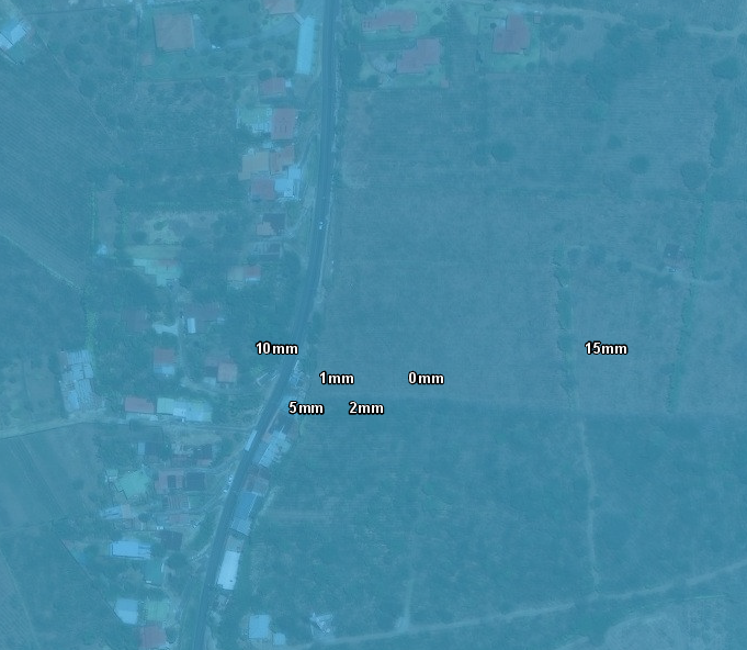
I'm trying to label an ImageLayer but all labels grouped all together:
I'm labeling with this:
I would like to see only the label of the feature or features that I'm watching. Thanks for any help that you can give me!
Solved! Go to Solution.
Accepted Solutions
- Mark as New
- Bookmark
- Subscribe
- Mute
- Subscribe to RSS Feed
- Permalink
- Report Inappropriate Content
Unfortunately, I think the issue you are seeing is caused by the data. Each feature (polygon) is labeled as close to the centroid as possible. So if there are no outlines for the features, it can appear that there is groupings when really there aren't.
Simplified sample using FeatureLayer instead of MapImageLayer
- Mark as New
- Bookmark
- Subscribe
- Mute
- Subscribe to RSS Feed
- Permalink
- Report Inappropriate Content
Hi Diego, what version of the API are you using, and what specific layer are you labeling? I'm not 100% sure what you mean by "ImageLayer".
- Mark as New
- Bookmark
- Subscribe
- Mute
- Subscribe to RSS Feed
- Permalink
- Report Inappropriate Content
Hi Noah
Sorry I forgot to tell that I´m using version 4.13.
What I meant with "ImageLayer" is for a MapImageLayer
I using this layer:
- Mark as New
- Bookmark
- Subscribe
- Mute
- Subscribe to RSS Feed
- Permalink
- Report Inappropriate Content
Unfortunately, I think the issue you are seeing is caused by the data. Each feature (polygon) is labeled as close to the centroid as possible. So if there are no outlines for the features, it can appear that there is groupings when really there aren't.
Simplified sample using FeatureLayer instead of MapImageLayer
- Mark as New
- Bookmark
- Subscribe
- Mute
- Subscribe to RSS Feed
- Permalink
- Report Inappropriate Content
Noah thanks a lot, I took it from NOAA and uploaded to the server with an arcpy script, seems that now they are making an overlapping of features :S, I didn't realice about that change, now I have to solve that, thank you very much!