- Home
- :
- All Communities
- :
- Developers
- :
- JavaScript Maps SDK
- :
- JavaScript Maps SDK Questions
- :
- JS API Error upgrading to 3.16+ from 3.11
- Subscribe to RSS Feed
- Mark Topic as New
- Mark Topic as Read
- Float this Topic for Current User
- Bookmark
- Subscribe
- Mute
- Printer Friendly Page
- Mark as New
- Bookmark
- Subscribe
- Mute
- Subscribe to RSS Feed
- Permalink
- Report Inappropriate Content
I'm developing an App based on the Tax Parcel Viewer solution: Tax Parcel Viewer | ArcGIS for Local Government . My variant has been running using JS API 3.11.
I now need to add a multi-property report, and FeatureTable capability as used in
https://developers.arcgis.com/javascript/3/jssamples/featuretable_custommenu.html is an ideal solution. The featureTable functionality requlred is not available in 3.11, but is in 3.16+.
I've tried to get my variant of TaxParcelViewer running under 3.16, 3.17, and 3.18.
In all cases I get the following error: Type Error: a.id.match is not a function.
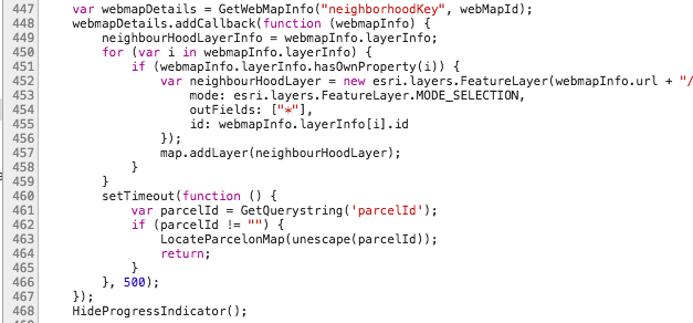
This is at map.addLayer on line 457, which runs without error under 3.11.

Any suggestions on how to resolve this error?
Chuck
Solved! Go to Solution.
Accepted Solutions
- Mark as New
- Bookmark
- Subscribe
- Mute
- Subscribe to RSS Feed
- Permalink
- Report Inappropriate Content
Per my favorite ESRI analyst:
I tested it and I noticed that the issue is actually coming from the js/locator.js file in line 698, , acutally there is a code defect, since sometime map.getLayer(neighbourHoodLayerInfo.id) is undefined, and in js api 3.11,it is not that sensitive, but in 3.18 it is more restrict on the code, so what you will need to do is just add another if statement outside of this if, so then it should look like this(I highlited the code that I added in line 697) :
line 696 for (var i in neighbourHoodLayerInfo) {
line 697 if (neighbourHoodLayerInfo.hasOwnProperty(i)&&map.getLayer(neighbourHoodLayerInfo.id)) {
line 698 if (map.getLayer(neighbourHoodLayerInfo.id).maxScale <= ((mapScale) ? mapScale :
Number(dojo.byId("divShareContainer").getAttribute("mapScale"))) &&
map.getLayer(neighbourHoodLayerInfo.id).minScale >= ((mapScale) ? mapScale :
Number(dojo.byId("divShareContainer").getAttribute("mapScale")))) {
line 699 PopulateNeighbourHoodInformation(neighbourHoodLayerInfo, mapPoint, null);
}
}
}
That fixed it!