- Home
- :
- All Communities
- :
- Developers
- :
- JavaScript Maps SDK
- :
- JavaScript Maps SDK Questions
- :
- JS API 4.11: [3D] No other line symbol style than ...
- Subscribe to RSS Feed
- Mark Topic as New
- Mark Topic as Read
- Float this Topic for Current User
- Bookmark
- Subscribe
- Mute
- Printer Friendly Page
JS API 4.11: [3D] No other line symbol style than solid ?
- Mark as New
- Bookmark
- Subscribe
- Mute
- Subscribe to RSS Feed
- Permalink
- Report Inappropriate Content
The question is simple,
how can I make a dashed or dotted line in SceneView ? I can't believe that there is not other symbol style than solid for 4.11 (so I must've missed something)
Thank you
Solved! Go to Solution.
Accepted Solutions
- Mark as New
- Bookmark
- Subscribe
- Mute
- Subscribe to RSS Feed
- Permalink
- Report Inappropriate Content
The pattern styles for lines in 3D are finally here!
With JS API 4.22 released this week, the 3D now supports the same set of styles as SimpleLineSymbol does for 2D. You can apply the new class LineStylePattern3D on a LineSymbol3DLayer or an outline of a polygon’s FillSymbol3DLayer.
Check out more about the line patterns and other new features in our release notes for 4.22.
- Mark as New
- Bookmark
- Subscribe
- Mute
- Subscribe to RSS Feed
- Permalink
- Report Inappropriate Content
Solid is indeed the only symbol style we currently support in SceneView. We have an issue for this, so it's in our roadmap, but it's not planned for the close future... can you tell us a bit about your use case for it? I can add your use case to the issue to increase the prio a bit. We could maybe also suggest a workaround in the meantime.
- Mark as New
- Bookmark
- Subscribe
- Mute
- Subscribe to RSS Feed
- Permalink
- Report Inappropriate Content
Raluca
We need this functionality for displaying different fault type lines for our map in 3D. Bump this up in priority please! Is there no work around or other options for dotted or dashed lines in 3D?
Jay
- Mark as New
- Bookmark
- Subscribe
- Mute
- Subscribe to RSS Feed
- Permalink
- Report Inappropriate Content
Thanks, Jay. Added your use case for increased priority.
Could you elaborate a bit on the purpose in 3D, maybe share a sample data set or screenshot?
Workarounds depend on what you are trying to achieve - approaches include e.g. customizing alternative 3D symbology (using e.g. color, size more prominently) or if the map is rendered draped to use tiled/dynamic map services where the map image is actually rendered server side.
- Mark as New
- Bookmark
- Subscribe
- Mute
- Subscribe to RSS Feed
- Permalink
- Report Inappropriate Content
Veronika,
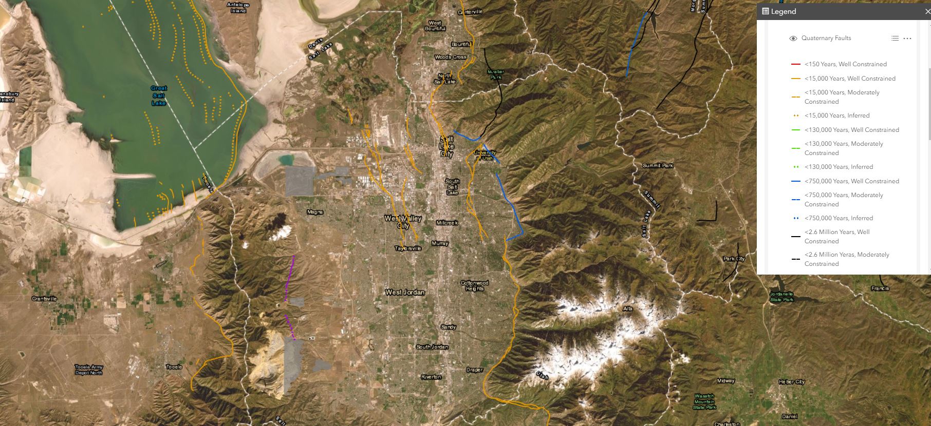
We are publishing faults that are already using color to symbolize ages and we need dashed and dotted line types to show mapping confidence. This seems like a basic cartographic requirement that should have been implemented already.
I have published a mapimagelayer to get around this problem for now. Below is a screenshot.
- Mark as New
- Bookmark
- Subscribe
- Mute
- Subscribe to RSS Feed
- Permalink
- Report Inappropriate Content
If I may add a usecase, we have mine sites, full 3D models etc. We also have the radio signal strengths from the radios to the heavy machinery, they had a few symbols for different type of signals and its quality.. since you cannot use the different polyline strokes, the map gets too crowded with quite a few colors and it's just not looking good.
From a developer perspective, I understand the pain, as it's no fun to render these things in webgl 😕
- Mark as New
- Bookmark
- Subscribe
- Mute
- Subscribe to RSS Feed
- Permalink
- Report Inappropriate Content
Thanks Michal, we have a ticket for this waiting in the pipeline and I've added your use case to it. I'll let you know when we'll start working on it.
- Mark as New
- Bookmark
- Subscribe
- Mute
- Subscribe to RSS Feed
- Permalink
- Report Inappropriate Content
@RalucaNicola1 Any update on this topic?
- Mark as New
- Bookmark
- Subscribe
- Mute
- Subscribe to RSS Feed
- Permalink
- Report Inappropriate Content
No updates Rickey. I will let you guys know when line styles make it into the product.
- Mark as New
- Bookmark
- Subscribe
- Mute
- Subscribe to RSS Feed
- Permalink
- Report Inappropriate Content
My organization also needs this functionality, also for denoting geological processes such as different fault lines. Also for consistency, as we often replicate our paper map symbology for clients using our webmaps