- Home
- :
- All Communities
- :
- Developers
- :
- JavaScript Maps SDK
- :
- JavaScript Maps SDK Questions
- :
- Increase maximum zoom level for a WebTiledLayer
- Subscribe to RSS Feed
- Mark Topic as New
- Mark Topic as Read
- Float this Topic for Current User
- Bookmark
- Subscribe
- Mute
- Printer Friendly Page
Increase maximum zoom level for a WebTiledLayer
- Mark as New
- Bookmark
- Subscribe
- Mute
- Subscribe to RSS Feed
- Permalink
- Report Inappropriate Content
I am using a WebTiledLayer to render a custom WMTS source. The WMTS I am using has zoom levels going from 18 to 21, however I cannot zoom in further than what appears to be zoom level 19. Does anyone know how to increase the maximum zoom level for a WebTiledLayer?
- Mark as New
- Bookmark
- Subscribe
- Mute
- Subscribe to RSS Feed
- Permalink
- Report Inappropriate Content
The basemaps used in in the map generally define how many levels of detail (LODs) that are available. It looks like the maximum for the Esri basemaps is 19. You can specify additional LODs in the map constructor. You will have to specify all the LODs you'll need in your map and make sure they match those in the WebTiledLayer that you're using.
Here's an example where I use a selected set of LODs.
map = new Map("divMap", {
  basemap: "osm"
  lods: [
          { "level": 0, "scale": 144447.638572, "resolution": 38.2185141425366 },
          { "level": 1, "scale": 72223.819286, "resolution": 19.1092570712683 },
          { "level": 2, "scale": 36111.909643, "resolution": 9.55462853563415 },
          { "level": 3, "scale": 18055.954822, "resolution": 4.77731426794937 },
          { "level": 4, "scale": 9027.977411, "resolution": 2.38865713397468 },
          { "level": 5, "scale": 4513.988705, "resolution": 1.19432856685505 },
          { "level": 6, "scale": 2256.994353, "resolution": 0.597164283559817 },
          { "level": 7, "scale": 1128.497176, "resolution": 0.298582141647617 }
        ],
  logo: false,
  showAttribution: false
});
- Mark as New
- Bookmark
- Subscribe
- Mute
- Subscribe to RSS Feed
- Permalink
- Report Inappropriate Content
Thank you for your reply Ken. My code for the map creation now looks like this:
 map = new Map("map", {
        center: new Point([4.4809346357564985, 51.92087577611635], new SpatialReference({wkid: 4326})),
        zoom: 18,
        basemap: "osm",
        lods: [
             {"level": 18, "scale": 2132.729583849784 / 1, "resolution": 0.5971642833948136 / 1},
             {"level": 19, "scale": 2132.729583849784 / 2, "resolution": 0.5971642833948136 / 2},
             {"level": 20, "scale": 2132.729583849784 / 4, "resolution": 0.5971642833948136 / 4},
             {"level": 21, "scale": 2132.729583849784 / 8, "resolution": 0.5971642833948136 / 8}
        ]
});
This results in nothing being drawn. Do you know if I made any mistakes?
- Mark as New
- Bookmark
- Subscribe
- Mute
- Subscribe to RSS Feed
- Permalink
- Report Inappropriate Content
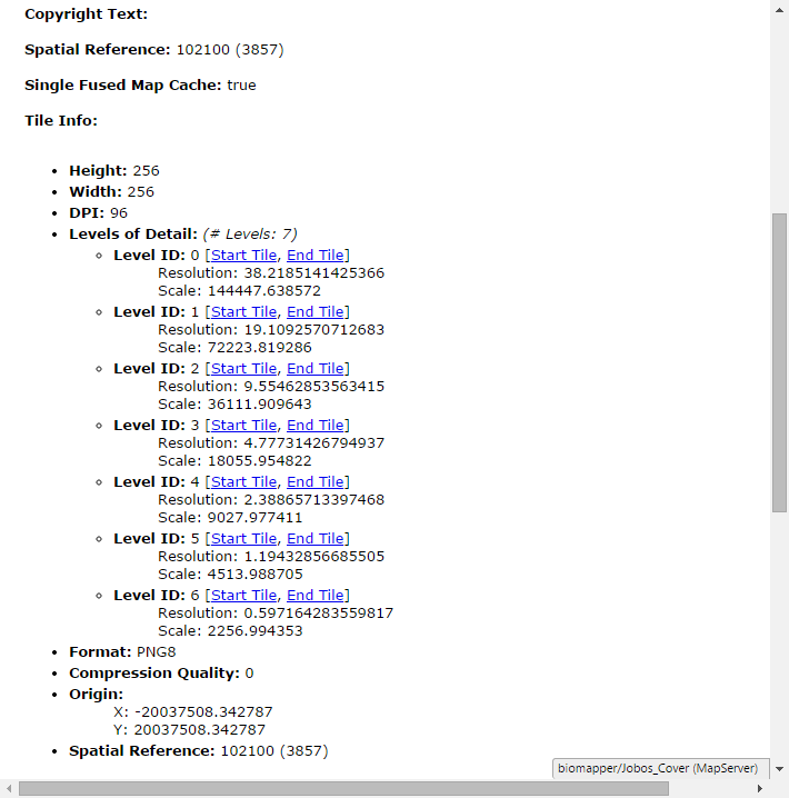
You should put the actual numbers in the scale and resolution that are in the Tile Info section of your map service page. Can you post what they are?
- Mark as New
- Bookmark
- Subscribe
- Mute
- Subscribe to RSS Feed
- Permalink
- Report Inappropriate Content
Hello Ken, I cannot see the information you posted because I am using a custom WMTS which does not display tile info. I can do a GetCapabilities request and see the various scales for various zoom levels but I cannot see the resolution. Do you have more information about the resolution property?