- Home
- :
- All Communities
- :
- Developers
- :
- JavaScript Maps SDK
- :
- JavaScript Maps SDK Questions
- :
- Re: Incomplete legend when print
- Subscribe to RSS Feed
- Mark Topic as New
- Mark Topic as Read
- Float this Topic for Current User
- Bookmark
- Subscribe
- Mute
- Printer Friendly Page
Incomplete legend when print
- Mark as New
- Bookmark
- Subscribe
- Mute
- Subscribe to RSS Feed
- Permalink
- Report Inappropriate Content
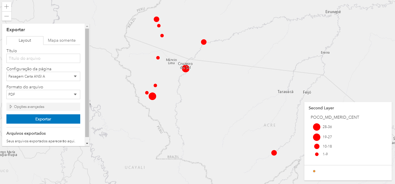
Hi guys! I have a problem with the captions when I print the map. Some caption items do not appear in the pdf (and others) and I was unable to find a pattern. This caption is generated through a ClassBreakRenderer. I'm forgetting something?
Caption generated with ClassBreakRenderer
Caption when printing
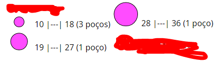
In the above case, the first banner does not appear when printing.
- Mark as New
- Bookmark
- Subscribe
- Mute
- Subscribe to RSS Feed
- Permalink
- Report Inappropriate Content
Hi guys! In an attempt to create an example to put here, I found that my problem was the print server !!! I had one in version 10.5 and one in version 10.61 and was using 10.61.
At 10.5 it worked perfectly! But there is a problem, this server will soon be updated to version 10.61, so my problem will come back. Do you know of any changes that were made from version 10.5 to 10.61 that may have caused this?
- Mark as New
- Bookmark
- Subscribe
- Mute
- Subscribe to RSS Feed
- Permalink
- Report Inappropriate Content
can you pls help us reproduce this on our side?
- Mark as New
- Bookmark
- Subscribe
- Mute
- Subscribe to RSS Feed
- Permalink
- Report Inappropriate Content
Hi. I updated this code (https://codepen.io/thafny/pen/OJMobdj?editors=1000 ) to exactly my problem. Unfortunately, I did not find a print service in version 10.61 public to put in the example, that is, the code will work well. But see, exactly the same code using the printing service in version 10.61, the return of the impression is as follows:
- Mark as New
- Bookmark
- Subscribe
- Mute
- Subscribe to RSS Feed
- Permalink
- Report Inappropriate Content
the sample code looks identical to one sent earlier. Is that just a typo or that is how it supposed to be?
also,
can you pls see whether you can reproduce this with the following print service
or, the agol default print service
https://utility.arcgisonline.com/arcgis/rest/services/Utilities/PrintingTools/GPServer/Export%20Web%...
- Mark as New
- Bookmark
- Subscribe
- Mute
- Subscribe to RSS Feed
- Permalink
- Report Inappropriate Content
Oh, I'm sorry !! I forgot to save the code. Try it now, please.The example I created uses the default print service goal.
I tried to use this other printing service, but I can't open the generated fil, look:

- Mark as New
- Bookmark
- Subscribe
- Mute
- Subscribe to RSS Feed
- Permalink
- Report Inappropriate Content
THanks.
This is what I'm seeing. Is that not what you expect?
Sorry trying to make sure I understood your problem correctly.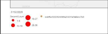
- Mark as New
- Bookmark
- Subscribe
- Mute
- Subscribe to RSS Feed
- Permalink
- Report Inappropriate Content
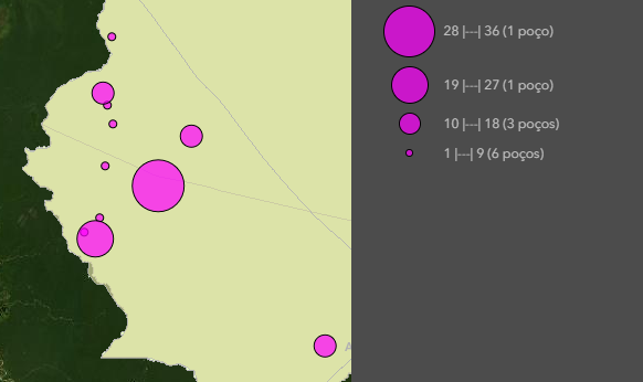
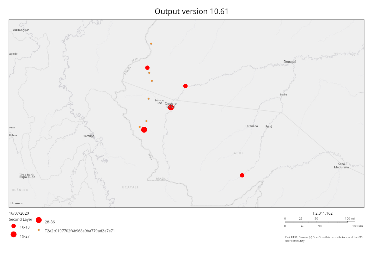
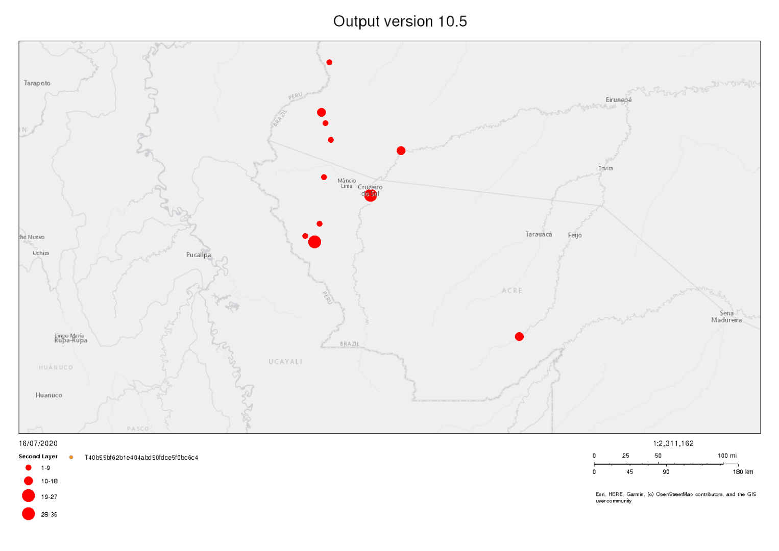
This is exactly the expected result. However, I cannot reproduce it using the print service in version 10.61. In the default version and version 10.5 it works perfectly, but in 10.61 the result is this:

Note that there is 1 class missing in the legend and some red dots are not being plotted.
- Mark as New
- Bookmark
- Subscribe
- Mute
- Subscribe to RSS Feed
- Permalink
- Report Inappropriate Content
can you pls do me a favor:
- send me outputs from 10.5.1 and 10.6.1
i'd like to see what is the difference - also use the browser's Dev Tools Network tab to capture the requests made by print widget to both 10.5.1 and 10.6.1 print service
- and send them to me
- Mark as New
- Bookmark
- Subscribe
- Mute
- Subscribe to RSS Feed
- Permalink
- Report Inappropriate Content
Hi, sure!
I attached 6 files.
MAPS: note that the maps are identical.
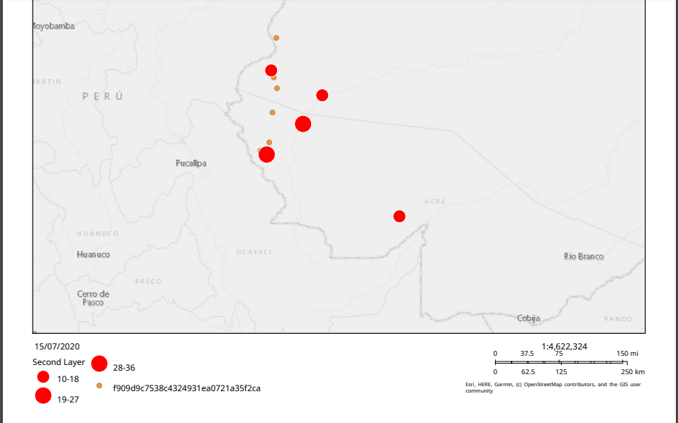
Map version 10.61

Map version 10.5
OUTPUT: note that in version 10.5 the output is exactly the same as on the map. In version 10.61, some data is not shown (red dots).
Output version 10.61
Output version 10.5
NETWORK: sorry, i was unable to attach the files.
Network 10.61
1 requests
517 B transferred
251 B resources

HEADERS
 GENERAL
 Request URL: http://giscorph-h4g5.petrobras.com.br/arcgis/rest/services/Utilities/PrintingTools/GPServer/Export%20Web%20Map%20Task/execute
 Request Method: POST
 Status Code: 200
 Remote Address: 10.29.119.145:80
 Referrer Policy: no-referrer-when-downgrade

RESPONSE HEADERS
 HTTP/1.1 200
 Server:
 Cache-Control: max-age=0,must-revalidate
 ETag: afceac65
 Content-Encoding: gzip
 Vary: Origin
 Date: Thu, 16 Jul 2020 11:10:19 GMT
 Access-Control-Allow-Origin: null
 Access-Control-Allow-Credentials: true
 Content-Type: application/json;charset=UTF-8
 Content-Length: 215

REQUEST HEADERS
 POST /arcgis/rest/services/Utilities/PrintingTools/GPServer/Export%20Web%20Map%20Task/execute HTTP/1.1
 Host: giscorph-h4g5.petrobras.com.br
 Connection: keep-alive
 Content-Length: 10856
 User-Agent: Mozilla/5.0 (Windows NT 10.0; Win64; x64) AppleWebKit/537.36 (KHTML, like Gecko) Chrome/83.0.4103.116 Safari/537.36
 Content-Type: application/x-www-form-urlencoded
 Accept: */*
 Origin: null
 Accept-Encoding: gzip, deflate
 Accept-Language: pt-BR,pt;q=0.9,en-US;q=0.8,en;q=0.7

FORM DATA
 Web_Map_as_JSON: {"operationalLayers":[{"url":"https://services.arcgisonline.com/ArcGIS/rest/services/Canvas/World_Light_Gray_Base/MapServer","id":"gray-base-layer","title":"World Light Gray Base","opacity":1,"minScale":0,"maxScale":0},{"featureCollection":{"layers":[{"layerDefinition":{"name":null,"geometryType":"esriGeometryPoint","drawingInfo":{"renderer":{"type":"simple","symbol":{"type":"esriSMS","color":[252,146,31,255],"angle":0,"xoffset":0,"yoffset":0,"size":6,"style":"esriSMSCircle","outline":{"type":"esriSLS","color":[153,153,153,255],"width":0.75,"style":"esriSLSSolid"}}}},"fields":[{"alias":"POCO_CD_POCO","editable":true,"length":-1,"name":"POCO_CD_POCO","nullable":true,"type":"esriFieldTypeOID"},{"alias":"POCO_MD_MERID_CENT","editable":true,"length":-1,"name":"POCO_MD_MERID_CENT","nullable":true,"type":"esriFieldTypeInteger"}]},"featureSet":{"geometryType":"esriGeometryPoint","features":[{"geometry":{"spatialReference":{"latestWkid":3857,"wkid":102100},"x":-8145129.73406924,"y":-840195.8149074552},"symbol":null,"attributes":{"POCO_CD_POCO":4523}},{"geometry":{"spatialReference":{"latestWkid":3857,"wkid":102100},"x":-8087037.592572523,"y":-862821.1752798614},"symbol":null,"attributes":{"POCO_CD_POCO":1340}},{"geometry":{"spatialReference":{"latestWkid":3857,"wkid":102100},"x":-8168366.590667928,"y":-913575.3620612053},"symbol":null,"attributes":{"POCO_CD_POCO":8830}},{"geometry":{"spatialReference":{"latestWkid":3857,"wkid":102100},"x":-8156748.162368584,"y":-920913.3167765803},"symbol":null,"attributes":{"POCO_CD_POCO":1592}},{"geometry":{"spatialReference":{"latestWkid":3857,"wkid":102100},"x":-7901754.236009304,"y":-1039543.5846751415},"symbol":null,"attributes":{"POCO_CD_POCO":2014}},{"geometry":{"spatialReference":{"latestWkid":3857,"wkid":102100},"x":-8150633.200105771,"y":-898287.956404174},"symbol":null,"attributes":{"POCO_CD_POCO":7944}},{"geometry":{"spatialReference":{"latestWkid":3857,"wkid":102100},"x":-8049124.826543085,"y":-807175.0186882677},"symbol":null,"attributes":{"POCO_CD_POCO":1010}},{"geometry":{"spatialReference":{"latestWkid":3857,"wkid":102100},"x":-8143295.245390397,"y":-772931.2300165177},"symbol":null,"attributes":{"POCO_CD_POCO":4437}},{"geometry":{"spatialReference":{"latestWkid":3857,"wkid":102100},"x":-8136568.7869013045,"y":-793722.1017100802},"symbol":null,"attributes":{"POCO_CD_POCO":17696}},{"geometry":{"spatialReference":{"latestWkid":3857,"wkid":102100},"x":-8148187.215200647,"y":-759478.3130383301},"symbol":null,"attributes":{"POCO_CD_POCO":4327}},{"geometry":{"spatialReference":{"latestWkid":3857,"wkid":102100},"x":-8138403.275580148,"y":-697105.6979576426},"symbol":null,"attributes":{"POCO_CD_POCO":4230}}]}}]},"id":"mainLayer","title":null,"opacity":1,"minScale":0,"maxScale":0},{"featureCollection":{"layers":[{"layerDefinition":{"name":"Second Layer","geometryType":"esriGeometryPoint","drawingInfo":{"renderer":{"type":"classBreaks","classBreakInfos":[{"label":"1-9","classMinValue":1,"classMaxValue":9,"symbol":{"type":"esriSMS","color":[255,0,0,255],"angle":0,"xoffset":0,"yoffset":0,"size":10,"style":"esriSMSCircle","outline":{"type":"esriSLS","color":[255,255,255,255],"width":0.75,"style":"esriSLSSolid"}}},{"label":"10-18","classMinValue":10,"classMaxValue":18,"symbol":{"type":"esriSMS","color":[255,0,0,255],"angle":0,"xoffset":0,"yoffset":0,"size":15,"style":"esriSMSCircle","outline":{"type":"esriSLS","color":[255,255,255,255],"width":0.75,"style":"esriSLSSolid"}}},{"label":"19-27","classMinValue":19,"classMaxValue":27,"symbol":{"type":"esriSMS","color":[255,0,0,255],"angle":0,"xoffset":0,"yoffset":0,"size":20,"style":"esriSMSCircle","outline":{"type":"esriSLS","color":[255,255,255,255],"width":0.75,"style":"esriSLSSolid"}}},{"label":"28-36","classMinValue":28,"classMaxValue":36,"symbol":{"type":"esriSMS","color":[255,0,0,255],"angle":0,"xoffset":0,"yoffset":0,"size":20,"style":"esriSMSCircle","outline":{"type":"esriSLS","color":[255,255,255,255],"width":0.75,"style":"esriSLSSolid"}}}],"field":"POCO_MD_MERID_CENT"}},"fields":[{"alias":"POCO_CD_POCO","editable":true,"length":-1,"name":"POCO_CD_POCO","nullable":true,"type":"esriFieldTypeOID"},{"alias":"POCO_MD_MERID_CENT","editable":true,"length":-1,"name":"POCO_MD_MERID_CENT","nullable":true,"type":"esriFieldTypeInteger"}]},"featureSet":{"geometryType":"esriGeometryPoint","features":[{"geometry":{"spatialReference":{"latestWkid":3857,"wkid":102100},"x":-8168366.590667928,"y":-913575.3620612053},"symbol":null,"attributes":{"POCO_MD_MERID_CENT":3}},{"geometry":{"spatialReference":{"latestWkid":3857,"wkid":102100},"x":-8150633.200105771,"y":-898287.956404174},"symbol":null,"attributes":{"POCO_MD_MERID_CENT":3}},{"geometry":{"spatialReference":{"latestWkid":3857,"wkid":102100},"x":-8156748.162368584,"y":-920913.3167765803},"symbol":null,"attributes":{"POCO_MD_MERID_CENT":20}},{"geometry":{"spatialReference":{"latestWkid":3857,"wkid":102100},"x":-8145129.73406924,"y":-840195.8149074552},"symbol":null,"attributes":{"POCO_MD_MERID_CENT":2}},{"geometry":{"spatialReference":{"latestWkid":3857,"wkid":102100},"x":-8136568.7869013045,"y":-793722.1017100802},"symbol":null,"attributes":{"POCO_MD_MERID_CENT":1}},{"geometry":{"spatialReference":{"latestWkid":3857,"wkid":102100},"x":-8143295.245390397,"y":-772931.2300165177},"symbol":null,"attributes":{"POCO_MD_MERID_CENT":5}},{"geometry":{"spatialReference":{"latestWkid":3857,"wkid":102100},"x":-8148187.215200647,"y":-759478.3130383301},"symbol":null,"attributes":{"POCO_MD_MERID_CENT":16}},{"geometry":{"spatialReference":{"latestWkid":3857,"wkid":102100},"x":-8138403.275580148,"y":-697105.6979576426},"symbol":null,"attributes":{"POCO_MD_MERID_CENT":7}},{"geometry":{"spatialReference":{"latestWkid":3857,"wkid":102100},"x":-8087037.592572523,"y":-862821.1752798614},"symbol":null,"attributes":{"POCO_MD_MERID_CENT":33}},{"geometry":{"spatialReference":{"latestWkid":3857,"wkid":102100},"x":-8049124.826543085,"y":-807175.0186882677},"symbol":null,"attributes":{"POCO_MD_MERID_CENT":14}},{"geometry":{"spatialReference":{"latestWkid":3857,"wkid":102100},"x":-7901754.236009304,"y":-1039543.5846751415},"symbol":null,"attributes":{"POCO_MD_MERID_CENT":15}}]}}]},"id":"secondLayer","title":"Second Layer","opacity":1,"minScale":0,"maxScale":0},{"url":"https://services.arcgisonline.com/ArcGIS/rest/services/Canvas/World_Light_Gray_Reference/MapServer","id":"gray-reference-layer","title":"World Light Gray Reference","opacity":1,"minScale":0,"maxScale":0}],"mapOptions":{"extent":{"spatialReference":{"latestWkid":3857,"wkid":102100},"xmin":-8463996.47958301,"ymin":-1079844.150118631,"xmax":-7628692.6344826445,"ymax":-678091.1294517647},"spatialReference":{"latestWkid":3857,"wkid":102100},"showAttribution":true,"scale":2311162.217155},"exportOptions":{"dpi":96},"layoutOptions":{"titleText":"Output version 10.61","authorText":"","copyrightText":"","customTextElements":[{"date":"16/07/2020"}],"scaleBarOptions":{},"legendOptions":{"operationalLayers":[{"id":"mainLayer"},{"id":"secondLayer"}]}}}
 Format: PNG32
 Layout_Template: A3 Landscape
 f: json

PREVIEW
{results: [{paramName: "Output_File", dataType: "GPDataFile", value: {,…}}], messages: []}
messages: []
results: [{paramName: "Output_File", dataType: "GPDataFile", value: {,…}}]
0: {paramName: "Output_File", dataType: "GPDataFile", value: {,…}}
dataType: "GPDataFile"
paramName: "Output_File"
value: {,…}
url: "http://giscorph-h4g5.petrobras.com.br/arcgis/rest/directories/arcgisoutput/Utilities/PrintingTools_GPServer/_ags_ec0a88be-c754-11ea-a436-005056971e54.png"

RESPONSE
{"results":[{"paramName":"Output_File","dataType":"GPDataFile","value":{"url":"http://giscorph-h4g5.petrobras.com.br/arcgis/rest/directories/arcgisoutput/Utilities/PrintingTools_GPServer/_ags_ec0a88be-c754-11ea-a436-005056971e54.png"}}],"messages":[]}
Network 10.5
1 requests
497 B transferred
228 B resources

HEADERS
 GENERAL
 Request URL: http://10.28.25.79/arcgis/rest/services/Utilities/PrintingTools/GPServer/Export%20Web%20Map%20Task/execute
 Request Method: POST
 Status Code: 200
 Remote Address: 10.28.25.79:80
 Referrer Policy: no-referrer-when-downgrade

RESPONSE HEADERS
 HTTP/1.1 200
 Access-Control-Allow-Origin: null
 Access-Control-Allow-Credentials: true
 Server:
 Cache-Control: max-age=0,must-revalidate
 ETag: 1ffde571
 Content-Encoding: gzip
 Vary: Origin
 Date: Thu, 16 Jul 2020 11:23:48 GMT
 Content-Type: text/plain;charset=utf-8
 Content-Length: 201

REQUEST HEADERS
 POST /arcgis/rest/services/Utilities/PrintingTools/GPServer/Export%20Web%20Map%20Task/execute HTTP/1.1
 Host: 10.28.25.79
 Connection: keep-alive
 Content-Length: 10856
 User-Agent: Mozilla/5.0 (Windows NT 10.0; Win64; x64) AppleWebKit/537.36 (KHTML, like Gecko) Chrome/83.0.4103.116 Safari/537.36
 Content-Type: application/x-www-form-urlencoded
 Accept: */*
 Origin: null
 Accept-Encoding: gzip, deflate
 Accept-Language: pt-BR,pt;q=0.9,en-US;q=0.8,en;q=0.7

FORM DATA
 Web_Map_as_JSON: {"operationalLayers":[{"url":"https://services.arcgisonline.com/ArcGIS/rest/services/Canvas/World_Light_Gray_Base/MapServer","id":"gray-base-layer","title":"World Light Gray Base","opacity":1,"minScale":0,"maxScale":0},{"featureCollection":{"layers":[{"layerDefinition":{"name":null,"geometryType":"esriGeometryPoint","drawingInfo":{"renderer":{"type":"simple","symbol":{"type":"esriSMS","color":[252,146,31,255],"angle":0,"xoffset":0,"yoffset":0,"size":6,"style":"esriSMSCircle","outline":{"type":"esriSLS","color":[153,153,153,255],"width":0.75,"style":"esriSLSSolid"}}}},"fields":[{"alias":"POCO_CD_POCO","editable":true,"length":-1,"name":"POCO_CD_POCO","nullable":true,"type":"esriFieldTypeOID"},{"alias":"POCO_MD_MERID_CENT","editable":true,"length":-1,"name":"POCO_MD_MERID_CENT","nullable":true,"type":"esriFieldTypeInteger"}]},"featureSet":{"geometryType":"esriGeometryPoint","features":[{"geometry":{"spatialReference":{"latestWkid":3857,"wkid":102100},"x":-8087037.592572523,"y":-862821.1752798614},"symbol":null,"attributes":{"POCO_CD_POCO":1340}},{"geometry":{"spatialReference":{"latestWkid":3857,"wkid":102100},"x":-8168366.590667928,"y":-913575.3620612053},"symbol":null,"attributes":{"POCO_CD_POCO":8830}},{"geometry":{"spatialReference":{"latestWkid":3857,"wkid":102100},"x":-8156748.162368584,"y":-920913.3167765803},"symbol":null,"attributes":{"POCO_CD_POCO":1592}},{"geometry":{"spatialReference":{"latestWkid":3857,"wkid":102100},"x":-7901754.236009304,"y":-1039543.5846751415},"symbol":null,"attributes":{"POCO_CD_POCO":2014}},{"geometry":{"spatialReference":{"latestWkid":3857,"wkid":102100},"x":-8150633.200105771,"y":-898287.956404174},"symbol":null,"attributes":{"POCO_CD_POCO":7944}},{"geometry":{"spatialReference":{"latestWkid":3857,"wkid":102100},"x":-8049124.826543085,"y":-807175.0186882677},"symbol":null,"attributes":{"POCO_CD_POCO":1010}},{"geometry":{"spatialReference":{"latestWkid":3857,"wkid":102100},"x":-8136568.7869013045,"y":-793722.1017100802},"symbol":null,"attributes":{"POCO_CD_POCO":17696}},{"geometry":{"spatialReference":{"latestWkid":3857,"wkid":102100},"x":-8148187.215200647,"y":-759478.3130383301},"symbol":null,"attributes":{"POCO_CD_POCO":4327}},{"geometry":{"spatialReference":{"latestWkid":3857,"wkid":102100},"x":-8138403.275580148,"y":-697105.6979576426},"symbol":null,"attributes":{"POCO_CD_POCO":4230}},{"geometry":{"spatialReference":{"latestWkid":3857,"wkid":102100},"x":-8143295.245390397,"y":-772931.2300165177},"symbol":null,"attributes":{"POCO_CD_POCO":4437}},{"geometry":{"spatialReference":{"latestWkid":3857,"wkid":102100},"x":-8145129.73406924,"y":-840195.8149074552},"symbol":null,"attributes":{"POCO_CD_POCO":4523}}]}}]},"id":"mainLayer","title":null,"opacity":1,"minScale":0,"maxScale":0},{"featureCollection":{"layers":[{"layerDefinition":{"name":"Second Layer","geometryType":"esriGeometryPoint","drawingInfo":{"renderer":{"type":"classBreaks","classBreakInfos":[{"label":"1-9","classMinValue":1,"classMaxValue":9,"symbol":{"type":"esriSMS","color":[255,0,0,255],"angle":0,"xoffset":0,"yoffset":0,"size":10,"style":"esriSMSCircle","outline":{"type":"esriSLS","color":[255,255,255,255],"width":0.75,"style":"esriSLSSolid"}}},{"label":"10-18","classMinValue":10,"classMaxValue":18,"symbol":{"type":"esriSMS","color":[255,0,0,255],"angle":0,"xoffset":0,"yoffset":0,"size":15,"style":"esriSMSCircle","outline":{"type":"esriSLS","color":[255,255,255,255],"width":0.75,"style":"esriSLSSolid"}}},{"label":"19-27","classMinValue":19,"classMaxValue":27,"symbol":{"type":"esriSMS","color":[255,0,0,255],"angle":0,"xoffset":0,"yoffset":0,"size":20,"style":"esriSMSCircle","outline":{"type":"esriSLS","color":[255,255,255,255],"width":0.75,"style":"esriSLSSolid"}}},{"label":"28-36","classMinValue":28,"classMaxValue":36,"symbol":{"type":"esriSMS","color":[255,0,0,255],"angle":0,"xoffset":0,"yoffset":0,"size":20,"style":"esriSMSCircle","outline":{"type":"esriSLS","color":[255,255,255,255],"width":0.75,"style":"esriSLSSolid"}}}],"field":"POCO_MD_MERID_CENT"}},"fields":[{"alias":"POCO_CD_POCO","editable":true,"length":-1,"name":"POCO_CD_POCO","nullable":true,"type":"esriFieldTypeOID"},{"alias":"POCO_MD_MERID_CENT","editable":true,"length":-1,"name":"POCO_MD_MERID_CENT","nullable":true,"type":"esriFieldTypeInteger"}]},"featureSet":{"geometryType":"esriGeometryPoint","features":[{"geometry":{"spatialReference":{"latestWkid":3857,"wkid":102100},"x":-8049124.826543085,"y":-807175.0186882677},"symbol":null,"attributes":{"POCO_MD_MERID_CENT":14}},{"geometry":{"spatialReference":{"latestWkid":3857,"wkid":102100},"x":-8087037.592572523,"y":-862821.1752798614},"symbol":null,"attributes":{"POCO_MD_MERID_CENT":33}},{"geometry":{"spatialReference":{"latestWkid":3857,"wkid":102100},"x":-8136568.7869013045,"y":-793722.1017100802},"symbol":null,"attributes":{"POCO_MD_MERID_CENT":1}},{"geometry":{"spatialReference":{"latestWkid":3857,"wkid":102100},"x":-8156748.162368584,"y":-920913.3167765803},"symbol":null,"attributes":{"POCO_MD_MERID_CENT":20}},{"geometry":{"spatialReference":{"latestWkid":3857,"wkid":102100},"x":-7901754.236009304,"y":-1039543.5846751415},"symbol":null,"attributes":{"POCO_MD_MERID_CENT":15}},{"geometry":{"spatialReference":{"latestWkid":3857,"wkid":102100},"x":-8138403.275580148,"y":-697105.6979576426},"symbol":null,"attributes":{"POCO_MD_MERID_CENT":7}},{"geometry":{"spatialReference":{"latestWkid":3857,"wkid":102100},"x":-8148187.215200647,"y":-759478.3130383301},"symbol":null,"attributes":{"POCO_MD_MERID_CENT":16}},{"geometry":{"spatialReference":{"latestWkid":3857,"wkid":102100},"x":-8150633.200105771,"y":-898287.956404174},"symbol":null,"attributes":{"POCO_MD_MERID_CENT":3}},{"geometry":{"spatialReference":{"latestWkid":3857,"wkid":102100},"x":-8168366.590667928,"y":-913575.3620612053},"symbol":null,"attributes":{"POCO_MD_MERID_CENT":3}},{"geometry":{"spatialReference":{"latestWkid":3857,"wkid":102100},"x":-8145129.73406924,"y":-840195.8149074552},"symbol":null,"attributes":{"POCO_MD_MERID_CENT":2}},{"geometry":{"spatialReference":{"latestWkid":3857,"wkid":102100},"x":-8143295.245390397,"y":-772931.2300165177},"symbol":null,"attributes":{"POCO_MD_MERID_CENT":5}}]}}]},"id":"secondLayer","title":"Second Layer","opacity":1,"minScale":0,"maxScale":0},{"url":"https://services.arcgisonline.com/ArcGIS/rest/services/Canvas/World_Light_Gray_Reference/MapServer","id":"gray-reference-layer","title":"World Light Gray Reference","opacity":1,"minScale":0,"maxScale":0}],"mapOptions":{"extent":{"spatialReference":{"latestWkid":3857,"wkid":102100},"xmin":-8481118.37391889,"ymin":-1100940.7699253338,"xmax":-7645814.5288185235,"ymax":-729151.0643462548},"spatialReference":{"latestWkid":3857,"wkid":102100},"showAttribution":true,"scale":2311162.217155},"exportOptions":{"dpi":96},"layoutOptions":{"titleText":"Output version 10.5","authorText":"","copyrightText":"","customTextElements":[{"date":"16/07/2020"}],"scaleBarOptions":{},"legendOptions":{"operationalLayers":[{"id":"mainLayer"},{"id":"secondLayer"}]}}}
 Format: PNG32
 Layout_Template: A3 Landscape
 f: json

PREVIEW
{results: [{paramName: "Output_File", dataType: "GPDataFile", value: {,…}}], messages: []}
messages: []
results: [{paramName: "Output_File", dataType: "GPDataFile", value: {,…}}]
0: {paramName: "Output_File", dataType: "GPDataFile", value: {,…}}
dataType: "GPDataFile"
paramName: "Output_File"
value: {,…}
url: "http://10.28.25.79/arcgis/rest/directories/arcgisoutput/Utilities/PrintingTools_GPServer/_ags_57b27e0a8a1f47fd94e8b267ecd87489.png"

RESPONSE
{"results":[{"paramName":"Output_File","dataType":"GPDataFile","value":{"url":"http://10.28.25.79/arcgis/rest/directories/arcgisoutput/Utilities/PrintingTools_GPServer/_ags_57b27e0a8a1f47fd94e8b267ecd87489.png"}}],"messages":[]}
If you need anything else, let me know.
- Mark as New
- Bookmark
- Subscribe
- Mute
- Subscribe to RSS Feed
- Permalink
- Report Inappropriate Content
Thanks a lot Thafny Soares. Appreciate all your help in providing screenshots and webmap json.
Looking at the screnshots, it looks like the problem is that in 10.6.1 output some point features are drawn in orange instead of red, correct?