Turn on suggestions
Auto-suggest helps you quickly narrow down your search results by suggesting possible matches as you type.
Cancel
- Home
- :
- All Communities
- :
- Developers
- :
- JavaScript Maps SDK
- :
- JavaScript Maps SDK Questions
- :
- How to find which raster pixels are within a buffe...
Options
- Subscribe to RSS Feed
- Mark Topic as New
- Mark Topic as Read
- Float this Topic for Current User
- Bookmark
- Subscribe
- Mute
- Printer Friendly Page
How to find which raster pixels are within a buffer geometry using RasterLayer API
Subscribe
736
0
08-19-2016 04:06 AM
08-19-2016
04:06 AM
- Mark as New
- Bookmark
- Subscribe
- Mute
- Subscribe to RSS Feed
- Permalink
- Report Inappropriate Content
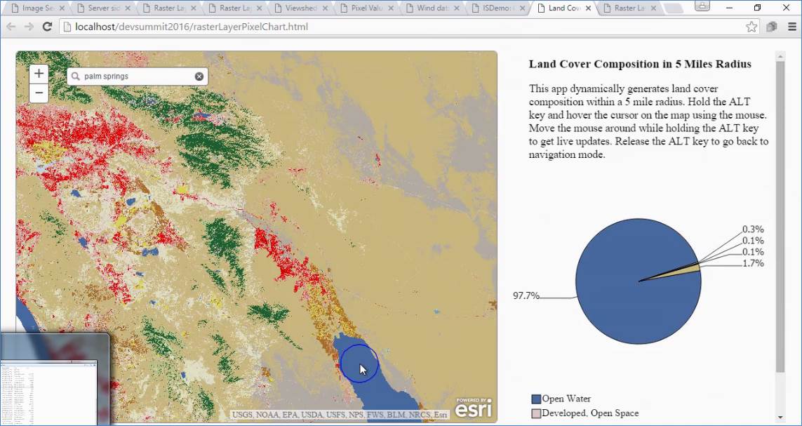
Consider this ImageService which is a Land cover raster layer with many classes e.g, forest, water, shrubland. I am trying to use the new RasterLayer API to find which pixels are within the buffer geometry and summarize the areas of forest, water, shrubland within the buffer geometry. Is this possible?
I can see the pixelData, but how does one find which pixel lies within the buffer geometry? and then compute the areas for each class within the buffer geometry.
I did see a similar example being demonstrated in one of the videos at video.arcgis.com (pl see screenshot). Not sure how they did that, any clues?
0 Replies