- Home
- :
- All Communities
- :
- Developers
- :
- JavaScript Maps SDK
- :
- JavaScript Maps SDK Questions
- :
- Re: Collapsible Layer List
- Subscribe to RSS Feed
- Mark Topic as New
- Mark Topic as Read
- Float this Topic for Current User
- Bookmark
- Subscribe
- Mute
- Printer Friendly Page
- Mark as New
- Bookmark
- Subscribe
- Mute
- Subscribe to RSS Feed
- Permalink
- Report Inappropriate Content
Looking for any examples of a collapsible layer list that Auto fills with my layers.
I have seen some really basic layer list examples on the api page but nothing that allows collapsible areas and auto filling of your layers.
I am trying to create 3 different areas as seen below. Were the box next to the ------------- would collapse that section.
But I want it to auto fill the layers from my .js page.

Right now I am adding layers to the list and adding check boxes BUT THERE it is not collapsible
legendLayers.push({ layer: FloodZonelayer, title: 'Flood Zones' });
// ADD CHECK BOXES FOR LAYERS
map.on('layers-add-result', function () {
//add check boxes
arrayUtils.forEach(legendLayers, function (layer) {
var layerName = layer.title;
var checkBox = new CheckBox({
name: "checkBox" + layer.layer.id,
value: layer.layer.id,
checked: layer.layer.visible
});
checkBox.on("change", function () {
var targetLayer = map.getLayer(this.value);
targetLayer.setVisibility(!targetLayer.visible);
this.checked = targetLayer.visible;
});
//add the check box and label to the toc
domConstruct.place(checkBox.domNode, dom.byId("toggle"), "after");
var checkLabel = domConstruct.create('label', {
'for': checkBox.name,
innerHTML: layerName
}, checkBox.domNode, "after");
domConstruct.place("<br />", checkLabel, "after");
});
});
//ADD THE LEGEND AND XY COORDINATES
map.on("layers-add-result", function (evt) {
// CYCLE through and grab all the layer names to add to the LEGEND PLUS
// Remove layers not inteneted for the legend.
var layerInfo = arrayUtils.map(evt.layers, function (layer, index) {
if (layer.layer.id === "PastLocations" || layer.layer.id === "District" || layer.layer.id === "weatherlayer") { return { }; } //Hides Layers in the Legend
else { return { layer: layer.layer, title: layer.layer.name }; } //Else return All others
});
// CYCLE through and grab all the layer names to add to the LEGEND
if (layerInfo.length > 0) {
var legendDijit = new Legend({
map: map,
layerInfos: layerInfo,
}, "legend");
legendDijit.startup();
legendDijit.refresh();
}
});
Solved! Go to Solution.
Accepted Solutions
- Mark as New
- Bookmark
- Subscribe
- Mute
- Subscribe to RSS Feed
- Permalink
- Report Inappropriate Content
I know this is not the way to do this although I don know of any other way to accomplish what I am looking for...
This is how I put on a large band-aid
- I still have to clean up the CSS to hide the clumsiness of this approach...especially with nesting the accordion panes..
- I still have to clean up my code so don't be too judgmental I repeated the code to build the legend layers in each of the accordion panes.
- I can put if then statements in this section to decrease the amount of code - map.on('layers-add-result', function () {
This gives you something like this in your panel... I have a container for Weather, Incidents, Other Layers.
If I do a little CSS work I can get ride of the frames and color backgrounds and make this look a little more appealing.
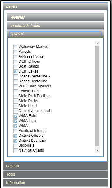
The example below does not have all the layers in the image. In my below example it would simply put one feature layer in each of the 3 accordions
Follow the "legendLayers1.push" below from each FeatureLayer to the function below it.
legendLayers1.push({ layer: WeatherImpactWashout, title: 'WeatherImpact Washout' });
legendLayers2.push({ layer: WeatherImpactWashout, title: 'WeatherImpact Washout' });
legendLayers2.push({ layer: WeatherImpactWashout, title: 'WeatherImpact Washout' });
<div id="IDAccordionPaneLayers" data-dojo-type="dijit.layout.AccordionContainer" style="color:black; height:90%; width:90%;">
<div id="idLayers2" data-dojo-type="dijit.layout.ContentPane" data-dojo-props="title:'Weather'" >
<div data-dojo-type="dijit/layout/ContentPane" data-dojo-props="title:'Natural Disasters'">
<div id="toggle2" style="padding: 2px 2px; color:Black;"></div>
</div>
</div>
<div id="idLayers3" data-dojo-type="dijit.layout.ContentPane" data-dojo-props="title:'Incidents & Traffic'" >
<div data-dojo-type="dijit/layout/ContentPane" data-dojo-props="title:'Natural Disasters'">
<div id="toggle3" style="padding: 2px 2px; color:Black;"></div>
</div>
</div>
<div id="idLayers1" data-dojo-type="dijit.layout.ContentPane" data-dojo-props="title:'Layers1'" >
<div data-dojo-type="dijit/layout/ContentPane" data-dojo-props="title:'Natural Disasters'">
<div id="toggle1" style="padding: 2px 2px; color:Black;"></div>
</div>
</div>
</div>var WeatherImpactPowerLines = new FeatureLayer("https://arcgis.vdem.virginia.gov/ArcGIS/rest/services/Traffic/VATraffic_WeatherImpactPoints/MapServe...", {
mode: FeatureLayer.MODE_ONDEMAND,
visible: false,
outFields:["*"],
infoTemplate: infoWeatherImpact
});
legendLayers1.push({ layer: WeatherImpactPowerLines, title: 'WeatherImpact Power Lines' });
var WeatherImpactOther = new FeatureLayer("https://arcgis.vdem.virginia.gov/ArcGIS/rest/services/Traffic/VATraffic_WeatherImpactPoints/MapServe...", {
mode: FeatureLayer.MODE_ONDEMAND,
visible: false,
outFields:["*"],
infoTemplate: infoWeatherImpact
});
legendLayers2.push({ layer: WeatherImpactOther, title: 'WeatherImpact Other' });
var WeatherImpactPassable = new FeatureLayer("https://arcgis.vdem.virginia.gov/ArcGIS/rest/services/Traffic/VATraffic_WeatherImpactPoints/MapServe...", {
mode: FeatureLayer.MODE_ONDEMAND,
visible: false,
outFields:["*"],
infoTemplate: infoWeatherImpact
});
legendLayers3.push({ layer: WeatherImpactPassable, title: 'WeatherImpact Passable' });
// ADD CHECK BOXES FOR LAYERS
map.on('layers-add-result', function () {
//add check boxes
arrayUtils.forEach(legendLayers1, function (layer) {
var layerName = layer.title;
var checkBox = new CheckBox({
name: "checkBox" + layer.layer.id,
value: layer.layer.id,
checked: layer.layer.visible
});
checkBox.on("change", function () {
var targetLayer = map.getLayer(this.value);
targetLayer.setVisibility(!targetLayer.visible);
this.checked = targetLayer.visible;
});
//add the check box and label to the toc
//domConstruct.place(checkBox.domNode, dom.byId("toggle"), "after");
domConstruct.place(checkBox.domNode, dom.byId("toggle1"), "after");
var checkLabel = domConstruct.create('label', {
'for': checkBox.name,
innerHTML: layerName
}, checkBox.domNode, "after");
domConstruct.place("<br />", checkLabel, "after");
});
arrayUtils.forEach(legendLayers2, function (layer) {
var layerName = layer.title;
var checkBox = new CheckBox({
name: "checkBox" + layer.layer.id,
value: layer.layer.id,
checked: layer.layer.visible
});
checkBox.on("change", function () {
var targetLayer = map.getLayer(this.value);
targetLayer.setVisibility(!targetLayer.visible);
this.checked = targetLayer.visible;
});
//add the check box and label to the toc
//domConstruct.place(checkBox.domNode, dom.byId("toggle"), "after");
domConstruct.place(checkBox.domNode, dom.byId("toggle1"), "after");
var checkLabel = domConstruct.create('label', {
'for': checkBox.name,
innerHTML: layerName
}, checkBox.domNode, "after");
domConstruct.place("<br />", checkLabel, "after");
});
arrayUtils.forEach(legendLayers3, function (layer) {
var layerName = layer.title;
var checkBox = new CheckBox({
name: "checkBox" + layer.layer.id,
value: layer.layer.id,
checked: layer.layer.visible
});
checkBox.on("change", function () {
var targetLayer = map.getLayer(this.value);
targetLayer.setVisibility(!targetLayer.visible);
this.checked = targetLayer.visible;
});
//add the check box and label to the toc
//domConstruct.place(checkBox.domNode, dom.byId("toggle"), "after");
domConstruct.place(checkBox.domNode, dom.byId("toggle1"), "after");
var checkLabel = domConstruct.create('label', {
'for': checkBox.name,
innerHTML: layerName
}, checkBox.domNode, "after");
domConstruct.place("<br />", checkLabel, "after");
});
});
//ADD THE LEGEND AND XY COORDINATES
map.on("layers-add-result", function (evt) {
// CYCLE through and grab all the layer names to add to the LEGEND PLUS
// Remove layers not inteneted for the legend.
var layerInfo = arrayUtils.map(evt.layers, function (layer, index) {
if (layer.layer.id === "PastLocations" || layer.layer.id === "District" || layer.layer.id === "weatherlayer") { return { }; } //Hides Layers in the Legend
else { return { layer: layer.layer, title: layer.layer.name }; } //Else return All others
});
// CYCLE through and grab all the layer names to add to the LEGEND
if (layerInfo.length > 0) {
var legendDijit = new Legend({
map: map,
layerInfos: layerInfo,
}, "legend");
legendDijit.startup();
legendDijit.refresh();
}
});
map.addLayers([
WeatherImpactPassable,WeatherImpactOther,WeatherImpactPowerLines
]);- Mark as New
- Bookmark
- Subscribe
- Mute
- Subscribe to RSS Feed
- Permalink
- Report Inappropriate Content
I saw this example but its using a web map I have my layers all defined individually in my js page
But this is the functionality I am after....but I am not using a web map
- Mark as New
- Bookmark
- Subscribe
- Mute
- Subscribe to RSS Feed
- Permalink
- Report Inappropriate Content
Here is that sample using coded layers like you are wanting:
<!DOCTYPE html>
<html>
<head>
<meta http-equiv="Content-Type" content="text/html; charset=utf-8">
<meta name="viewport" content="initial-scale=1, maximum-scale=1,user-scalable=no">
<title>Layer List Dijit</title>
<link rel="stylesheet" href="http://js.arcgis.com/3.25/dijit/themes/claro/claro.css">
<link rel="stylesheet" href="http://js.arcgis.com/3.25/esri/css/esri.css">
<style>
html,
body,
.container,
#map {
height: 100%;
width: 100%;
margin: 0;
padding: 0;
margin: 0;
font-family: "Open Sans";
}
#map {
padding: 0;
}
#layerListPane {
width: 25%;
}
.esriLayer {
background-color: #fff;
}
.esriLayerList .esriList {
border-top: none;
}
.esriLayerList .esriTitle {
background-color: #fff;
border-bottom: none;
}
.esriLayerList .esriList ul {
background-color: #fff;
}
</style>
<script>
var dojoConfig = {
parseOnLoad: true
};
</script>
<script src="http://js.arcgis.com/3.25/"></script>
<script>
require([
"esri/map",
"esri/layers/ArcGISDynamicMapServiceLayer",
"esri/dijit/LayerList",
"dojo/query",
"dojo/dom-construct",
"dojo/dom-class",
"dojo/dom-style",
"dojo/on",
"dojo/_base/array",
"dijit/layout/BorderContainer",
"dijit/layout/ContentPane",
"dojo/domReady!"
], function (
Map,
ArcGISDynamicMapServiceLayer,
LayerList,
query,
domConstruct,
domClass,
domStyle,
on,
array
) {
var map = new Map("map", {
basemap: "topo",
center: [-123, 47],
zoom: 8,
sliderStyle: "small"
});
var atlasLayer = new ArcGISDynamicMapServiceLayer("http://sampleserver6.arcgisonline.com/arcgis/rest/services/Census/MapServer", {
"id": "atlasLayer",
"showAttribution": false
});
var recreationLayer = new ArcGISDynamicMapServiceLayer("http://sampleserver6.arcgisonline.com/arcgis/rest/services/Recreation/MapServer", {
"id": "recreationLayer",
"showAttribution": false
});
var waterNetLayer = new ArcGISDynamicMapServiceLayer("http://sampleserver6.arcgisonline.com/arcgis/rest/services/Water_Network/MapServer", {
"id": "waterNetworkLayer",
"showAttribution": false
})
map.addLayers([atlasLayer, recreationLayer, waterNetLayer]);
var llWidget = new LayerList({
map: map,
layers: [{
layer: atlasLayer,
id: "Atlas layers",
subLayers: true
},{
layer: recreationLayer,
id: "Recreation Layer",
subLayers: true
},{
layer: waterNetLayer,
id: "Water Network Layer",
subLayers: true
}],
showLegend: true,
showOpacitySlider: true
},"layerList");
llWidget.startup();
});
</script>
</head>
<body class="claro">
<div class="container" data-dojo-type="dijit/layout/BorderContainer" data-dojo-props="design:'headline',gutters:false">
<div id="layerListPane" data-dojo-type="dijit/layout/ContentPane" data-dojo-props="region:'right'">
<div id="layerList"></div>
</div>
<div id="map" data-dojo-type="dijit/layout/ContentPane" data-dojo-props="region:'center'"></div>
</div>
</body>
</html>- Mark as New
- Bookmark
- Subscribe
- Mute
- Subscribe to RSS Feed
- Permalink
- Report Inappropriate Content
So from what I am seeing there are 3 map services each with an array of layers in them.
This reads through each service and creates the list allowing them to collapse?
- Mark as New
- Bookmark
- Subscribe
- Mute
- Subscribe to RSS Feed
- Permalink
- Report Inappropriate Content
Correct
- Mark as New
- Bookmark
- Subscribe
- Mute
- Subscribe to RSS Feed
- Permalink
- Report Inappropriate Content
Thinking.....I have infotemplates as well to control what I see. On a few of them I am doing more than simply reading from the Service for symbology etc.
Can I handle this with this code example?
// ADDRESS POINTS
var simpleJson = {
"type": "simple",
"label": "",
"description": "",
"symbol": {
"color": [255,255,51],
"size": 6,
"angle": 0,
"xoffset": 0,
"yoffset": 0,
"type": "esriSMS",
"style": "esriSMSCircle",
"outline": {
"color": [255,0,0],
"width": 1,
"type": "esriSLS",
"style": "esriSLSSolid"
}
}
}
var infoTemplateAddressPoints = new InfoTemplate();
infoTemplateAddressPoints.setTitle("Address Point Information");
infoTemplateAddressPoints.setContent("<table>" +
"<tr><td id='tblTitle'>Address Pts</td><td id='tblTitle2'></td></tr>" +
"<tr><td id='tblTitleLine'></td><td id='tblTitleLine2'></td></tr>" +
"<tr><td></td><td></td></tr>" +
"<tr><td id='tblMainline1'>Address</td><td id='tblSubline2'>${FULLADDR}</td></tr>" +
"<tr><td id='tblMainline1'>Municipality</td><td id='tblSubline2'>${MUNICIPALITY}</td></tr>" +
"<tr><td id='tblMainline1'>PO Name</td><td id='tblSubline2'>${PO_NAME}</td></tr>" +
"<tr><td id='tblMainline1'>Zip Code</td><td id='tblSubline2'>${ZIP_5}</td></tr>" +
"</table><hr>");
var AddressPointEndPoint = "https://xxxxxx/arcgis/rest/services/VA_Base_layers/VA_Address_Points/MapServer/0";
var AddressPoints = new FeatureLayer(AddressPointEndPoint, {
id: "AddressPoint",
minScale: 50000,
visible: true,
opacity: .7,
outFields: ["*"],
infoTemplate: infoTemplateAddressPoints
});
// Push layer to the legend
legendLayers.push({ layer: AddressPoints, title: 'Address Points' });
var rend = new SimpleRenderer(simpleJson);
AddressPoints.setRenderer(rend)- Mark as New
- Bookmark
- Subscribe
- Mute
- Subscribe to RSS Feed
- Permalink
- Report Inappropriate Content
Jay,
Sure what I provided was just an example. All you really need of the code I provided is this portion:
var llWidget = new LayerList({
map: map,
layers: [{
layer: atlasLayer,
id: "Atlas layers",
subLayers: true
},{
layer: recreationLayer,
id: "Recreation Layer",
subLayers: true
},{
layer: waterNetLayer,
id: "Water Network Layer",
subLayers: true
}],
showLegend: true,
showOpacitySlider: true
},"layerList");
llWidget.startup();You just change the layer property for your actual layer vars.
- Mark as New
- Bookmark
- Subscribe
- Mute
- Subscribe to RSS Feed
- Permalink
- Report Inappropriate Content
Say I wanted the Recreation in the atlasLayer Can I do this?
var llWidget = new LayerList({
map: map,
layers: [{
layer: atlasLayer,recreationLayer,
id: "Atlas layers",
subLayers: true
},
{
layer: recreationLayer,
id: "Recreation Layer",
subLayers: true
},{
layer: waterNetLayer,
id: "Water Network Layer",
subLayers: true
}],
showLegend: true,
showOpacitySlider: true
},"layerList");
llWidget.startup();
- Mark as New
- Bookmark
- Subscribe
- Mute
- Subscribe to RSS Feed
- Permalink
- Report Inappropriate Content
No. One layer per layer property.
- Mark as New
- Bookmark
- Subscribe
- Mute
- Subscribe to RSS Feed
- Permalink
- Report Inappropriate Content
So if I have 20 individual layers from multiple sources, with InfoTemplates.....
I want 3 categories...using your example...trying to figure out how I get like 10 in the first, 5 in the second and 5 in the third.... Each category will have layers from multiple sources....some external and some internal
Say I had this. How do I get both of these in onto the atlasLayer
// WMA LINE
var WMAFL = new FeatureLayer("https://xxxx/arcgis/rest/services/Projects/AVL/MapServer/4", {
mode: FeatureLayer.MODE_SNAPSHOT,
visible: true
});
// WMA FEATURES POINT
var WMAFPt = new FeatureLayer("https://xxxx/arcgis/rest/services/Projects/Locations/MapServer/2", {
mode: FeatureLayer.MODE_SNAPSHOT,
visible: true
});var llWidget = new LayerList({
map: map,
layers: [{
layer: atlasLayer, // I WANT BOTH LAYERS IN THIS CATEGORY
id: "Atlas layers",
subLayers: true
},
{
layer: recreationLayer,
id: "Recreation Layer",
subLayers: true
},{
layer: waterNetLayer,
id: "Water Network Layer",
subLayers: true
}],
showLegend: true,
showOpacitySlider: true
},"layerList");
llWidget.startup();