- Home
- :
- All Communities
- :
- Developers
- :
- JavaScript Maps SDK
- :
- JavaScript Maps SDK Questions
- :
- Change symbols for Feature Layer hosted on externa...
- Subscribe to RSS Feed
- Mark Topic as New
- Mark Topic as Read
- Float this Topic for Current User
- Bookmark
- Subscribe
- Mute
- Printer Friendly Page
Change symbols for Feature Layer hosted on external server
- Mark as New
- Bookmark
- Subscribe
- Mute
- Subscribe to RSS Feed
- Permalink
- Report Inappropriate Content
I am attempting to modify a FeatureLayer's symbology on the client side and having some issues. Because I do not have access to the hosted feature service and the symbology returned is incorrect, I am wondering if this can be done after the FeatureLayer is created.
The reason I cannot assign the symbol at creation time is because there are 9 unique features. Each feature has a graphic as SimpleFillSymbol with the same outline color. Is it possible to correct the outline colors for each of the 9 returned features when I query the feature layer in mode_ondemand?
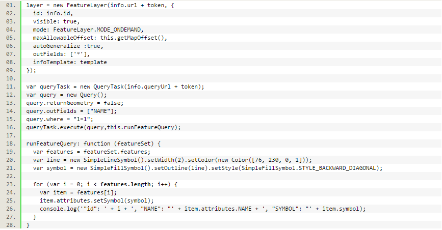
Code Snippet:
-Kate
- Mark as New
- Bookmark
- Subscribe
- Mute
- Subscribe to RSS Feed
- Permalink
- Report Inappropriate Content
Kate,
have you looked into UniqueValueRenderer?
UniqueValueRenderer | API Reference | ArcGIS API for JavaScript
- Mark as New
- Bookmark
- Subscribe
- Mute
- Subscribe to RSS Feed
- Permalink
- Report Inappropriate Content
You should be able to do this- you just need to apply a new renderer to the featureLayer after you create it. I have done this with a feature service from the USGS of earthquakes. Here's my snippit that changes the symbology from its default service symbology to what I wanted:
        var theUsgsEarthquakeLayer = new FeatureLayer("http://igems.doi.gov/arcgis/rest/services/igems_haz/MapServer/3", {
          id: "quakes",
          mode: FeatureLayer.MODE_ONDEMAND,
          refreshInterval: 5,
          autoGeneralize: false,
          outFields: ["*"]
        });

        if (theUsgsEarthquakeLayer != null) {
            //define a popup template
            var usgsQuakeTemplate = new InfoTemplate();
            usgsQuakeTemplate.setContent(formatQuakeContent);
            usgsQuakeTemplate.setTitle("Magnitude ${magnitude} Earthquake");
            theUsgsEarthquakeLayer.setInfoTemplate(usgsQuakeTemplate);
            theUsgsEarthquakeLayer.setAutoGeneralize(false);
            //Create a different renderer with new symbols
            var renderer = new ClassBreaksRenderer(null, "magnitude");
            renderer.addBreak(0, 3, blueMarkerSymb);
            renderer.addBreak(3, 5, greenMarkerSymb);
            renderer.addBreak(5, 7, orangeMarkerSymb);
            renderer.addBreak(7, 9, redMarkerSymb);
            renderer.addBreak(9, Infinity, purpleMarkerSymb);


            theUsgsEarthquakeLayer.setRenderer(renderer);
        } else {
            // Define the USGS Earthquake layer retrieved from a KML file instead
            theUsgsEarthquakeLayer = new KMLLayer("http://earthquake.usgs.gov/earthquakes/feed/v1.0/summary/1.0_week_age_link.kml", {
                id: 'quakes',
                refreshInterval: 5,
                visible: true
            });
        }
- Mark as New
- Bookmark
- Subscribe
- Mute
- Subscribe to RSS Feed
- Permalink
- Report Inappropriate Content
Worked like magic. Great examples, thank you both for sharing this!
-K