I am using feature reduction for a map layer, but I need to be able to pull the geometry from each of the features included in a given cluster. I have looked at the _clusterManager properties and there is no property that includes this information. I want to add a mouseover event that shows the extent of all of the features in a cluster. Please see pic below.
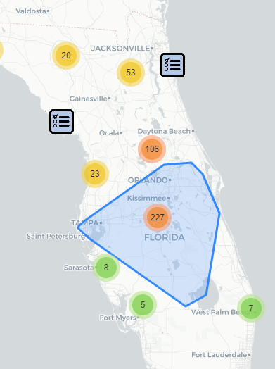
I have my cluster radius set to 70, and according to esri docs, this is measured in points. I have no idea what kind of conversion I need to do to find all features that are within 70 pts of the cluster center. Also, do the points represent map points, or screen points? Here is my code:
gLyr.on("mouse-over", lang.hitch(this, function(evt) {
        map.setMapCursor("pointer");
        let eCtr = evt.screenPoint;
        let w = window.screen.width;
        let h = window.screen.height;
        let ext = map.extent;
        let spArr = []
        if(evt.graphic.hasOwnProperty("_aggregationInfo")) {
          QueryGraphics.forEach(function(g) {
            //console.log("graphics geometry ", g.geometry);
            //let mapCoord = webMercatorUtils.lngLatToXY(g.geometry.x,
              //g.geometry.y);
            let Pt = new Point(g.geometry.x, g.geometry.y);
            let sp = screenUtils.toScreenPoint(ext, w, h, Pt);
            let dist = Math.sqrt(Math.pow((eCtr.x - sp.x),2) +
                       Math.pow((eCtr.y - sp.y),2));
            console.log("graphics distance = ", dist);
            if ( dist <= 70) {
              spArr.push(g);
              console.log("cluster graphic ", g);
            }
          });
          console.log("graphics array ", spArr);  //returns empty array
        }
I have assumed that the distance calculation is based on screen points and am converting the lat/lon coordinates of each feature into screen points using screenUtils. I then apply a distance calculation to get the distance between each feature and the screen point of the cluster, but it isn't returning any features within the cluster radius. Does anyone know what I am doing wrong, and what units of measurement I should be using if not screen points?
Thanks!
