- Home
- :
- All Communities
- :
- Developers
- :
- JavaScript Maps SDK
- :
- JavaScript Maps SDK Questions
- :
- Select features and zoom to layers
- Subscribe to RSS Feed
- Mark Topic as New
- Mark Topic as Read
- Float this Topic for Current User
- Bookmark
- Subscribe
- Mute
- Printer Friendly Page
- Mark as New
- Bookmark
- Subscribe
- Mute
- Subscribe to RSS Feed
- Permalink
- Report Inappropriate Content
I am trying to select highlight features and zoom to selected features layer extent.My code below runs but doesn't highlight any feature.
on(dom.byId("try"), "click", function () {
var queryTask = new QueryTask("http://localhost:6080/arcgis/rest/services/RAEC/MapServer/12");
//build query filter
var que = new Query();
que.returnGeometry = true;
que.outFields = ["FeederID", "OBJECTID"];
que.outSpatialReference = { "wkid": 32640 };
que.where = "FeederID<> ''";
symbol = new SimpleMarkerSymbol();
symbol.setStyle(SimpleMarkerSymbol.STYLE_SQUARE);
symbol.setSize(10);
symbol.setColor(new Color([255,255,0,0.5]));
queryTask.execute(que,showResults);
function showResults(featureSet) {
map.graphics.clear();
var resultFeatures = featureSet.features;
for (var i=0, il=resultFeatures.length; i<il; i++) {
var graphic = resultFeatures;
graphic.setSymbol(symbol);
map.graphics.add(graphic);
}
}
});
Solved! Go to Solution.
- Mark as New
- Bookmark
- Subscribe
- Mute
- Subscribe to RSS Feed
- Permalink
- Report Inappropriate Content
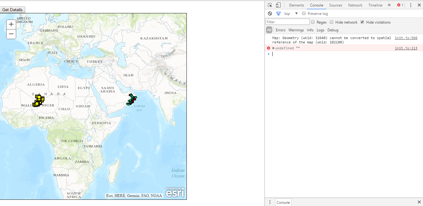
Dear Robert,
Please see the screenshot and error below:
- Mark as New
- Bookmark
- Subscribe
- Mute
- Subscribe to RSS Feed
- Permalink
- Report Inappropriate Content
But do you get the same result when you use the exact code I posted above?..
- Mark as New
- Bookmark
- Subscribe
- Mute
- Subscribe to RSS Feed
- Permalink
- Report Inappropriate Content
Yes i have copied the code which you posted and attached the screenshot of the error.
- Mark as New
- Bookmark
- Subscribe
- Mute
- Subscribe to RSS Feed
- Permalink
- Report Inappropriate Content
What version of ArcGIS Server are you using?
- Mark as New
- Bookmark
- Subscribe
- Mute
- Subscribe to RSS Feed
- Permalink
- Report Inappropriate Content
10.2.2
- Mark as New
- Bookmark
- Subscribe
- Mute
- Subscribe to RSS Feed
- Permalink
- Report Inappropriate Content
Can you update your code by adding line 6 below and tell me the results of the console?
function showResults(featureSet) {
//remove all graphics on the maps graphics layer
map.graphics.clear();
//Performance enhancer - assign featureSet array to a single variable.
var resultFeatures = featureSet.features;
console.info(resultFeatures[0].geometry.spatialReference.wkid);
//Loop through each feature returned
for (var i = 0, il = resultFeatures.length; i < il; i++) {
//Get the current feature from the featureSet.
//Feature is a graphic
var graphic = resultFeatures[i];
graphic.setSymbol(symbol);
//Set the infoTemplate.
graphic.setInfoTemplate(infoTemplate);
//Add graphic to the map graphics layer.
map.graphics.add(graphic);
}
}- Mark as New
- Bookmark
- Subscribe
- Mute
- Subscribe to RSS Feed
- Permalink
- Report Inappropriate Content
32640
- Mark as New
- Bookmark
- Subscribe
- Mute
- Subscribe to RSS Feed
- Permalink
- Report Inappropriate Content
OK, That is what does not make sense then.
query = new Query();
query.returnGeometry = true;
query.outFields = ["FeederID"];
query.outSpatialReference = map.spatialReference;line 2 and line 4 should cause the returned queries geometry to be in the maps spatial reference (WKID 102100).
You could try to manually set it:
query.outSpatialReference = {"wkid": 102100};- Mark as New
- Bookmark
- Subscribe
- Mute
- Subscribe to RSS Feed
- Permalink
- Report Inappropriate Content
finally giving manual spatial reference work. Thank you Robert for your time and support
- « Previous
-
- 1
- 2
- Next »
- « Previous
-
- 1
- 2
- Next »