- Home
- :
- All Communities
- :
- Developers
- :
- JavaScript Maps SDK
- :
- JavaScript Maps SDK Questions
- :
- LabelingInfo on 4.13 JS API
- Subscribe to RSS Feed
- Mark Topic as New
- Mark Topic as Read
- Float this Topic for Current User
- Bookmark
- Subscribe
- Mute
- Printer Friendly Page
- Mark as New
- Bookmark
- Subscribe
- Mute
- Subscribe to RSS Feed
- Permalink
- Report Inappropriate Content
Hello everyone!
I have a question concerning the ArcGIS JS 4.13 API
Up until now I've been using 4.12 version of the API to show a hosted Feature Layer containing Polygon geometries. To that, I have added a labelingInfo object in order to show a Field from the data of the Polygons. In 4.12 many labels were shown throughout the map even without zooming.
After updating to 4.13, the number of labels has been reduced almost by half without changing anything in the code. I don't see anything relevant in the Changelogs though I think that the change happened for optimisation purposes.
Is there a way to change the density of the shown labels? There isn't anything mentioned in the docs concerning such an option
Thank you everyone in advance!
PS. I can provide screenshots if needed
Solved! Go to Solution.
Accepted Solutions
- Mark as New
- Bookmark
- Subscribe
- Mute
- Subscribe to RSS Feed
- Permalink
- Report Inappropriate Content
Hi Alex Zotos! Yes this change was made in 4.13 for a few reasons, one is the performance as you already mentioned. The second was that due to some improvements in the label fade logic, we increased the number of instances in which we are able to fade labels in/out (e.g., on rotation). With too many labels, this became quite distracting.The last reason was because we received some feedback that the labeling was too cluttered. Exposing this as a configurable option is a good idea, and we'll look into seeing what we can do.
- Mark as New
- Bookmark
- Subscribe
- Mute
- Subscribe to RSS Feed
- Permalink
- Report Inappropriate Content
Hi Alex, thanks for the feedback. We did make some optimization changes at 4.13, but if you could provide some screenshots of what you're seeing, that would be very helpful.
- Mark as New
- Bookmark
- Subscribe
- Mute
- Subscribe to RSS Feed
- Permalink
- Report Inappropriate Content
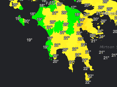
Hello Noah!
I am attaching two images showing the same area (same layer without any changes), after only applying the update from version 4.12 to version 4.13. The update has the same effect throughout the whole layer
The problem is not that the labels are less after the update since it probably helps with the speed of the rendering. It would be good though if a way to affect it programmatically through the API existed.
Version 4.13:

Version 4.12:
- Mark as New
- Bookmark
- Subscribe
- Mute
- Subscribe to RSS Feed
- Permalink
- Report Inappropriate Content
Hi Alex Zotos! Yes this change was made in 4.13 for a few reasons, one is the performance as you already mentioned. The second was that due to some improvements in the label fade logic, we increased the number of instances in which we are able to fade labels in/out (e.g., on rotation). With too many labels, this became quite distracting.The last reason was because we received some feedback that the labeling was too cluttered. Exposing this as a configurable option is a good idea, and we'll look into seeing what we can do.
- Mark as New
- Bookmark
- Subscribe
- Mute
- Subscribe to RSS Feed
- Permalink
- Report Inappropriate Content
Hello Matt!
Thanks a lot for the explanation! I guess that for now we will stick to 4.12 which shows everything and then just use a different field for the labeling, populated only by some of the polygons to reduce the shown labels a bit.
Thank you for the help!