- Home
- :
- All Communities
- :
- Developers
- :
- JavaScript Maps SDK
- :
- JavaScript Maps SDK Questions
- :
- Re: Geocode and return results
- Subscribe to RSS Feed
- Mark Topic as New
- Mark Topic as Read
- Float this Topic for Current User
- Bookmark
- Subscribe
- Mute
- Printer Friendly Page
- Mark as New
- Bookmark
- Subscribe
- Mute
- Subscribe to RSS Feed
- Permalink
- Report Inappropriate Content
Initial Need: The user selects a point in the map and that defines the address in the form
I am looking for a solution that provides a certain level of interaction between a traditional web form and leveraging the ESRI JS api. What I am trying to do is proof a concept where a user can leverage the Find Address example below:
Search for an address | ArcGIS for Developers
I created this JS fiddle with some modifications to the example above
https://jsfiddle.net/Jaykapalczynski/6e0snvyr/3/
Edit fiddle - JSFiddle - Code Playground
In this example the user can click on the map.
This will geocode the Map Location and return an address and XY to variables
I can then use these variables to populate a couple textareas and most importantly to populate a Form on the page.
This works great.
ALTHOUGH - If I use the Find Address input box from the search widget I can enter and address and get the result in a popup. While this appears to solve my needs, I need to capture that Address and XY being returned to the popup (I am assuming the XY location is available some how.) I do NOT want the user to have to interact with the map...ONLY the Find Address input box. I cant seem to find a way to grab the results from the geocoding that are sent back via the Find Address or Place geocoder
Questions:
1. What I am having an issue with is .... capturing the result from the Find Address or Place search and th resulting popup that appears after the search is done (NOT a map click)....and writing those values (address, X, Y) to variables that I can split and push to the forms input boxes.
2. Is there a way to JUST display the "Find Address or Place" input box and get rid of the map and zoom tools? Or do I have to create a new widget? I dont care about the map and zoom tools.
If I have to create my own GP Service and handle the communication back and forth I will do so...but just thought this might be easier.
Solved! Go to Solution.
Accepted Solutions
- Mark as New
- Bookmark
- Subscribe
- Mute
- Subscribe to RSS Feed
- Permalink
- Report Inappropriate Content
Jay,
search.on("select-result", function (event) {
console.log(event.result.name, event.result.feature.geometry.x, event.result.feature.geometry.y);
});- Mark as New
- Bookmark
- Subscribe
- Mute
- Subscribe to RSS Feed
- Permalink
- Report Inappropriate Content
Trying this
Console.log gives me this
First alert gives me
[object Object]
Second alert does NOT show up.
Just need to get the Match Address and XY back...ugggg
// Search widget
var search = new Search({
view: view,
});
search.on("select-result", function (event) {
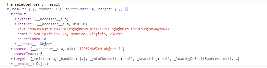
console.log("The selected search result: ", event);
test = event;
alert(test);
var vtest = event;
var vreturn = JSON.stringify(vtest);
alert(vreturn);
});- Mark as New
- Bookmark
- Subscribe
- Mute
- Subscribe to RSS Feed
- Permalink
- Report Inappropriate Content
I changed it to SEARCH-COMPLETE and I can get the number of results and the search term but I cant find out how to read the XY coordinates and the Match Address from the actual geocode?
Anyone?
// Search widget
var search = new Search({
view: view,
popupEnabled: false
});
search.on("search-complete", function (event) {
testnumber = event.numResults;
alert(testnumber);
//test = JSON.stringify(event.searchTerm);
test = event.searchTerm;
alert(test);
});- Mark as New
- Bookmark
- Subscribe
- Mute
- Subscribe to RSS Feed
- Permalink
- Report Inappropriate Content
Jay,
search.on("select-result", function (event) {
console.log(event.result.name, event.result.feature.geometry.x, event.result.feature.geometry.y);
});- Mark as New
- Bookmark
- Subscribe
- Mute
- Subscribe to RSS Feed
- Permalink
- Report Inappropriate Content
Dang I was dancing all around the solution...thank you much
last question....when I use the example above (js fiddle) and click on the map and it gives me decimal degrees...
When I use the input box to geocode the entered address it appears to be returning the coordinates in Web Aux Mercator? Is there a parameter I can set to return the coordinates into decimal degrees?
- Mark as New
- Bookmark
- Subscribe
- Mute
- Subscribe to RSS Feed
- Permalink
- Report Inappropriate Content
Jay,
Sure just change geometry.x to geometry.longitude and geometry.y to geometry.latitude
- Mark as New
- Bookmark
- Subscribe
- Mute
- Subscribe to RSS Feed
- Permalink
- Report Inappropriate Content
THANK YOU once again....very appreciated.