- Home
- :
- All Communities
- :
- Developers
- :
- JavaScript Maps SDK
- :
- JavaScript Maps SDK Questions
- :
- Re: esriRequest with multiple map layers
- Subscribe to RSS Feed
- Mark Topic as New
- Mark Topic as Read
- Float this Topic for Current User
- Bookmark
- Subscribe
- Mute
- Printer Friendly Page
esriRequest with multiple map layers
- Mark as New
- Bookmark
- Subscribe
- Mute
- Subscribe to RSS Feed
- Permalink
- Report Inappropriate Content
How do I return multiple layers including a map layer that is a definitionExpression when doing an esriRequest?
If I request a single map layer that is a definitionExpression, the map layer is returned.
{
"id": 1,
"layerDefinition": {
"drawingInfo": drawingInfo,
"source": {
"type": "mapLayer",
"mapLayerId": 1
},
"definitionExpression": "PARID='"+parid+"'"
}
}
If I request two map layers, one with a definitionExpression, no map layers are returned.
"layers": [ { "id": 256,
"layerDefinition": {
"source": {
"type": "mapLayer", "mapLayerId": 256 }
}
},
{
"id": 1,
"layerDefinition": {
"drawingInfo": drawingInfo,
"source": {
"type": "mapLayer",
"mapLayerId": 1
},
"definitionExpression": "PARID='"+parid+"'"
}
}
If I request a single map layer that is not a definitionExpression, the map layer is returned.
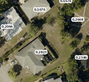
Example of map a single map layer shown in black text and white background

- Mark as New
- Bookmark
- Subscribe
- Mute
- Subscribe to RSS Feed
- Permalink
- Report Inappropriate Content
Can you post some code that shows what you are trying to accomplish? What version of the JS API are you using? I'm not sure how you're using esriRequest or what you mean by mapLayer.
- Mark as New
- Bookmark
- Subscribe
- Mute
- Subscribe to RSS Feed
- Permalink
- Report Inappropriate Content
I am constructing a json esriRequest and posting it to Printing Tools Task. The "layers" are in the request.
Post:
Raw request:
{"mapOptions":{"showAttribution":false,"extent":{"xmin":479389.87880438194,"ymin":1159369.4997793399,"xmax":479840.91235113516,"ymax":1159594.2281684615,"spatialReference":{"wkid":102659}},"spatialReference":{"wkid":102659},"rotation":0},"operationalLayers":[{"id":"World_Street_Map_417","title":"World_Street_Map_417","opacity":1,"minScale":0,"maxScale":0,"url":"https://www.foobar.org/arcgis01/rest/services/basemap/aerials/MapServer"},{"id":"WebLayers_2139","title":"WebLayers_2139","opacity":1,"minScale":0,"maxScale":0,"url":"https://gis.foobar.com/arcgis/rest/services/Website/WebLayers/MapServer","layers":[{"id":1,"layerDefinition":{"drawingInfo":{"renderer":{"type":"simple","symbol":{"type":"esriSFS","style":"esriSFSNull","outline":{"type":"esriSLS","style":"esriSLSSolid","color":[66,244,206],"width":3}}}},"source":{"type":"mapLayer","mapLayerId":1},"definitionExpression":"FOOBAR='1014100000'"}}]}],"exportOptions":{"outputSize":[400,400],"dpi":96}}
Encoded request:
https://gis.foobar.com/arcgis/rest/services/Utilities/PrintingTools/GPServer/Export%20Web%20Map%20Task/execute?Web_Map...foobar.org%2Farcgis01%2Frest%2Fservices%2Fbasemap%2Faerials%2FMapServer%22%7D%2C%7B%22id%22%3A%22WebLayers...foobar.com%2Farcgis%2Frest%2Fservices%2FWebsite%2FWebLayers%2FMapServer%22%2C%22layers%22%3A%5B%7B%22id%22...
- Mark as New
- Bookmark
- Subscribe
- Mute
- Subscribe to RSS Feed
- Permalink
- Report Inappropriate Content
Ok, sorry, I don't know how to help. What version of the JS API are you using? Are the layers MapImageLayers or FeatureLayers?
- Mark as New
- Bookmark
- Subscribe
- Mute
- Subscribe to RSS Feed
- Permalink
- Report Inappropriate Content
JS 4.13 feature layers