ArcGIS API for JavaScript (versions 4.4 and 3.21) releasing soon!

12250
17
06-20-2017 08:15 AM
JuliePowell
Esri Contributor
13 17 12.2K

New ArcGIS API for JavaScript releases are just around the corner! Here is a preview of some of the new capabilities coming in early July. 

(Note: These are some of the highlights; a full list of new capabilities and enhancements will be provided in the release notes.)

ArcGIS API 4.4 for JavaScript

New styles for points in city landscapes:

Styling the point data in city scenes can now be done more effectively. Point graphics can be configured to display above buildings with the new relative-to-scene elevation mode. Callout lines can be used to better understand point locations (a callout is essentially extended from the top of the scene).


Highlight in 3D:

The ability to highlight features in a 3D scene, with options to configure the color and opacity of the highlight effect.


Styling building data:

We added the option to remove building textures to better emphasize thematic mapping of buildings, and also the option to make textures grayscale (one example of when you might want to do this is if you want to draw attention away from the buildings, and highlight a particular set of interest).


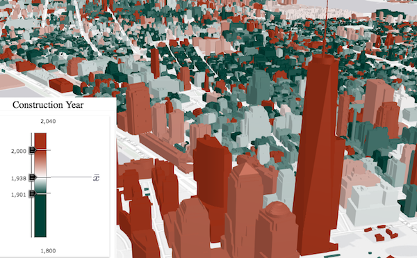
Smart Mapping

You can now automatically generate renderers for SceneLayers using SmartMapping. Generating type renderers with smart mapping is new to both 2D and 3D views. Note: When we reference smart mapping/generating renderers, we mean that the API creates smart defaults for your map/scene styles on the fly. This capability is typically used in data exploration type apps (as opposed to defining the styling explicitly in code).
 

PointCloudLayer enhancements

Added the ability to add natural lighting conditions to a point cloud layer in order to better distinguish objects.


Better web map support

Added support for Map Notes, WMS, and WMTS layers.


OGC support

Added support for WMS and WMTS layers.


VectorTileLayer printing

This release of the JavaScript API includes a support for vector tile layer printing through client-side image.


Arcade support in popups

Arcade expressions can now be applied in the popup’s content. This is useful for situations when you want to display data that isn't present as an attribute value in your FeatureLayer instance. Web maps that have been created in Portal or Online that contain popups with Arcade expressions will be honored in apps built with the JS API, and developers can also write Arcade expressions directly in their code.


Widget standardization

In this release, the following widgets have been updated to the widget framework, initially introduced at 4.2: Legend, Popup and Search widgets.

Custom Layers

The SDK will include documentation and samples for creating your own custom layers. 


ArcGIS API 3.21 for JavaScript 

Arcade support in popups

As described above.


VectorTileLayer printing

As described above.


(...plus minor enhancements and bug fixes)


17 Comments
ClintonCrick
New Contributor II

Any update on Draw and Edit capabilities for 4.x?

JuliePowell
Esri Contributor

The team is currently working hard on the sketching implementation for 4.x. We had hoped that we'd have an initial release of 2D draw tools in the 4.4 release, and while the team made good progress on the overall design and beginning implementation, it isn't ready for release. 4.5 is due out in the fall and we are working towards getting 2D drawing into that release. I can share any updates to this thread as the release approaches. 3D drawing will likely be next year.

The full *editing* experience will take more time and will be a multi-release implementation (that includes editing widgets). 

That being said, we will likely have a sample released with 4.4 that shows how you can simply use map events to draw a polygon (that is then used for a spatial query). For those of you that have projects that can't wait for OOB drawing in the API, you can use this code as an example for writing (simple) custom drawing tools. 

I hope that helps!

JordanKing3
New Contributor III
PhilLarkin1
Occasional Contributor III

When is the Measurement Widget planned for release on 4.x? 

JuliePowell
Esri Contributor

We are currently targeting the December release (4.6) for the measurement widget. However, 4.4 will have a sample demonstrating how you can implement simple measurement on your own using map events and the geometry engine. 

JuliePowell
Esri Contributor

Here is the simple measure sample that I was referring to: Measure while drawing | ArcGIS API for JavaScript 4.4 

JuliePowell
Esri Contributor

This is the draw sample I was referring to: Draw polygon for spatial query | ArcGIS API for JavaScript 4.4 

DavidColey
Frequent Contributor

Is there any indication when the selectFeatures capability for featureLayers will be available?  Thanks-

PhilLarkin1
Occasional Contributor III

Thanks Julie

PhilLarkin1
Occasional Contributor III

Hi julie_powell-esristaff

The Measurement Widget didn't make it into 4.6. Will it be available in 4.7 and do you have an estimate on 7's release date?

JadeFreeman
Occasional Contributor III

Is there a timeframe for when labeling featurelayers in 2D will be supported?  Thanks!

RobertScheitlin__GISP
MVP Emeritus

Jade,


   Why do you need so badly to label features on the client? You know you can have layers labeled on the server if you use an MapImageLayer right?

JadeFreeman
Occasional Contributor III

There are many use cases for labeling on the client or it would not have been introduced in the 3.x API and supported in 3D right? I am aware you can use a MapImage layer however, it would be nice to work with a feature layer client side including selection of features, labeling, tables etc.

RobertScheitlin__GISP
MVP Emeritus

There is a pretty big difference between nice to have and urgently needed though. It is a feature that is coming soon.

GertConradie
Occasional Contributor

Any update on when the first version of the edit capabilities is planned?

We are selecting the required API version for a project now, and user friendly functionality to edit the boundary of a polygon is the only showstopper to use 4.x. It would be great to know if the expected release date, potentially we can exclude some functionality - but one need a more specific date when decisions are being made .

Alternative suggestions would be much appreciated

RobertScheitlin__GISP
MVP Emeritus

Gert,


  4.8 at the earliest. The next release 4.7 will have more drawing tools but will still not have other required editing components like attribute inspector and others needed for full editing support.

PhilLarkin1
Occasional Contributor III

Hi Julie Powell


Sorry to be a pest, but this is really the last feature preventing the use of 4.x. The Measurement Widget didn't make it into 4.7. Is this a priority? Any idea when it might be included?

About the Author
http://www.linkedin.com/in/julieapowell