- Home
- :
- All Communities
- :
- User Groups
- :
- Addressing
- :
- Questions
- :
- Re: Why does the Address Locator not recognize Arc...
- Subscribe to RSS Feed
- Mark Topic as New
- Mark Topic as Read
- Float this Topic for Current User
- Bookmark
- Subscribe
- Mute
- Printer Friendly Page
Why does the Address Locator not recognize Arc Segments?
- Mark as New
- Bookmark
- Subscribe
- Mute
- Subscribe to RSS Feed
- Permalink
- Report Inappropriate Content
Background: attempting to create a Fishbones layer to validate addresses for our jurisdiction.
I've created a Dual Range Address Locator based off of our road centerlines. I geocoded a table of our addresses then used the XY to Line tool to create the Fishbone from our address points to the geocoded table. For the most part it was successful, but I noticed this in an area:

The geocoded results did not follow the road centerline feature. It actually is following an older, outdated centerline we've since updated. I've rebuilt the Locator several times and ensured the correct feature is selected as the Reference Data for the Locator. It still continues to reverse geocode to that older centerline, which is nowhere on my map.
Using the Address Inspector Tool, this is what I get:


Has anyone experienced this odd behavior when geocoding? Am I missing something? Am I going crazy? Any and all input is greatly appreciated.
tldr; reverse geocoding results are showing results from older feature.
EDIT 1: (Title also edited)
A colleague of mine and I were troubleshooting the problem and he stumbled upon the issue! It looks like the Address Locator and Address Inspector tool do NOT recognize segments created using the End Point Arc Segment/Arc Segment tools.
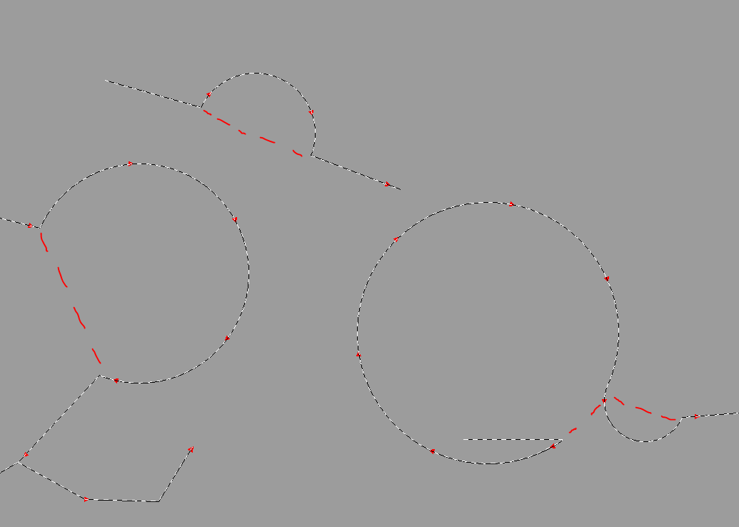
When using the Address Inspector tool for these segments, the tool completely ignores the arc and skips to the next vertex of the line (drawn red).
Now...has anyone experienced this or know why it does this?
- Mark as New
- Bookmark
- Subscribe
- Mute
- Subscribe to RSS Feed
- Permalink
- Report Inappropriate Content
What version of ArcGIS are you using? Are you in Pro and using the Create Locator Tool or the Create Address Locator Tool? If you are in ArcMap/Catalog, this statement catches my attention: I've rebuilt the Locator several times.
Does that mean you have deleted the locator and re-created it from scratch or are you right clicking on the locator in ArcCatalog and choosing 'Rebuild'. If you are doing the latter, ('Rebuild'), I suggest you do the former (delete and re-create). I've never had Rebuild work...
- Mark as New
- Bookmark
- Subscribe
- Mute
- Subscribe to RSS Feed
- Permalink
- Report Inappropriate Content
Joe,
Thanks for responding. I really appreciate your input. Sorry for not providing that information. I am using 10.3.0.4322 and using the Create Address Locator Tool. Data is Versioned, but Rec/Posted prior to rebuilding the locator.
That's very interesting that you say you've never had Rebuild work for you. But now that you pose that question, I've done both. I've Rebuilt an existing Locator AND built a brand new Locator with the same results. The only difference is that I didn't re-geocode my table after building a new Locator. I simply used the Address Inspector tool and experienced the same results (suggested address point locations still follow the old centerline feature).
I also found another road segment who's range's aren't correct when using the Address Inspector. The ranges were extended at an earlier date but the Locator hasn't taken those changes.
Just for testing's sake, I used a brand new road segment that was created more recently, ensured all ranges, LF, RF, LT, RTs were populated, geometry was correct, reconciled and posted to Default, then Rebuilt the Locator (which is not in the same database as the features). The Address Inspector was accurate.
- Mark as New
- Bookmark
- Subscribe
- Mute
- Subscribe to RSS Feed
- Permalink
- Report Inappropriate Content
Ben:
Are you saying that the address locator completely ignores curves (e.g. Bezier curves)? If so, is there any chance you can use a newer version of ArcMap than 10.3, maybe 10.5?
- Mark as New
- Bookmark
- Subscribe
- Mute
- Subscribe to RSS Feed
- Permalink
- Report Inappropriate Content
Michael,
Thank you for the response. Yes, the Locator completely ignores the curve when using the Address Inspector tool. Instead of following the curve to suggest addresses, it skips to the next vertex. Using the images in my original post under Edit 1, the Address Inspector tool will follow the red drawn line, not the curve.
Our IT team is supposed to be upgrading us soon but I don't know when that will happen. Has this bug been fixed in later versions?
- Mark as New
- Bookmark
- Subscribe
- Mute
- Subscribe to RSS Feed
- Permalink
- Report Inappropriate Content
I don't know the answer to that question, but I do know from experience that in older ArcMap versions 10.2 and possibly 10.3 I needed to do some extra processing on Bezier curves as they were not always recognized. This processing is no longer necessary (a nice relief) in newer versions. I'm hoping this problem can be solved with a simple upgrade.