- Home
- :
- All Communities
- :
- User Groups
- :
- Addressing
- :
- Questions
- :
- Composite Locator has matches but returns no spati...
- Subscribe to RSS Feed
- Mark Topic as New
- Mark Topic as Read
- Float this Topic for Current User
- Bookmark
- Subscribe
- Mute
- Printer Friendly Page
Composite Locator has matches but returns no spatial information
- Mark as New
- Bookmark
- Subscribe
- Mute
- Subscribe to RSS Feed
- Permalink
- Report Inappropriate Content
I have a composite address locator that has the following participating locators:
- Full Address (points)
- Street Centerline (for when an exact address match isn't found)
- Parcel APN (used when an address field isn't populated)
- Historical Parcel APN (when a record needs to be matched to an old parcel number)
I have a dataset with about 40k records that I geocoded using the composite locator and it matches all but ~800 of the records to the FullAddress locator using an Address field from the data.
Unfortunately when I try to pan to or zoom to individual locations on a map, it doesn't go anywhere... So I calculated x/y geometry but they all have no spatial location even though they say they matched...
Curious if I did something wrong creating the composite locator becuase when I use the FullAddress locator on its own it returns spatial information no problem.
Anybody else have an issue like this and have a solution?
- Mark as New
- Bookmark
- Subscribe
- Mute
- Subscribe to RSS Feed
- Permalink
- Report Inappropriate Content
Are you using the new style locators (Create Locator) and merging them into a composite locator by any chance? If so, this thread has relevant information.
The bottom line is, while it's technically supported, new style locators and composite locators are virtually unusable.
- Mark as New
- Bookmark
- Subscribe
- Mute
- Subscribe to RSS Feed
- Permalink
- Report Inappropriate Content
Kyle:
I don't see anything in comment you linked to that would lead me to believe the new locators and composite locators are unusable. Could you elaborate on your comment? I would definitely recommend using a multirole locator created with the Create Locator tool over a composite locator, but in a few instances you might find the need for a composite locator.
- Mark as New
- Bookmark
- Subscribe
- Mute
- Subscribe to RSS Feed
- Permalink
- Report Inappropriate Content
Shana,
Reverse geocoding does not work at all when mixing new locators and composite locators, that's a pretty important feature. Brad even says it's inadvisable to mix the new technology with the old, and it should only be used as a last resort or you have no need for reverse geocoding.
- Mark as New
- Bookmark
- Subscribe
- Mute
- Subscribe to RSS Feed
- Permalink
- Report Inappropriate Content
Kyle,
Your statement that "Reverse geocoding does not work at all when mixing new locators and composite locators" is not correct. The composite locators function and return results correctly but you will have less output than you would when using the new locator by itself. This is how the classic locators worked and how the classic locators inside of composite locators worked. With the composite locator that contains the newer locators created with the Create Locator tool, you will only get back the parsed out address for the reverse geocoded location instead of additional geocoding metadata that the mutlirole new locators return.
Brad
- Mark as New
- Bookmark
- Subscribe
- Mute
- Subscribe to RSS Feed
- Permalink
- Report Inappropriate Content
Kevin:
- I would check the geometry type (shape field) of the street centerline and parcel data to see if it is Z or M or ZM as there are a few bugs related to locators created with the Create Address Locator tool when if the reference data contains bad M extents the features do not show on the map or you cannot zoom to the matched results on the map if the output is saved to a geodatabase. In some cases saving the output to a shapefile resolves the problem, but in other cases removing the M values from the reference data feature class and rebuilding the locator with the M values removed solves the problem. http://support.esri.com/en/knowledgebase/techarticles/detail/35818
- I would also check the coordinate system of the reference data for each of the locators participating in the composite and if the same behavior occurs with the individual locators (Street Centerline, Parcel APN, Historical Parcel APN) by themselves.
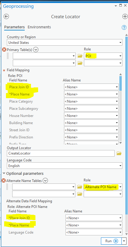
- Given the data you described I would create a multirole locator using the Create Locator tool in ArcGIS Pro 2.3+ using the following roles. The multirole locator will use the coordinate system of the reference data first in the list of primary tables
- PointAddress for Full Address (points)
- StreetAddress for Street Centerline
- POI for Parcel APN
- Map the APN to the Place Name locator role field
- Include an alternate name table of the historical parcel APN
- Use a JoinID to link the primary parcel data and historical parcel data together and map it to the Place Join ID field for the POI role and Alternate POI Name alternate name table role.