- Home
- :
- All Communities
- :
- Products
- :
- 3D
- :
- 3D Questions
- :
- Re: Create a multiple 3D polyline graph using dist...
- Subscribe to RSS Feed
- Mark Topic as New
- Mark Topic as Read
- Float this Topic for Current User
- Bookmark
- Subscribe
- Mute
- Printer Friendly Page
Create a multiple 3D polyline graph using distance from '0'
- Mark as New
- Bookmark
- Subscribe
- Mute
- Subscribe to RSS Feed
- Permalink
- Report Inappropriate Content
Hello,
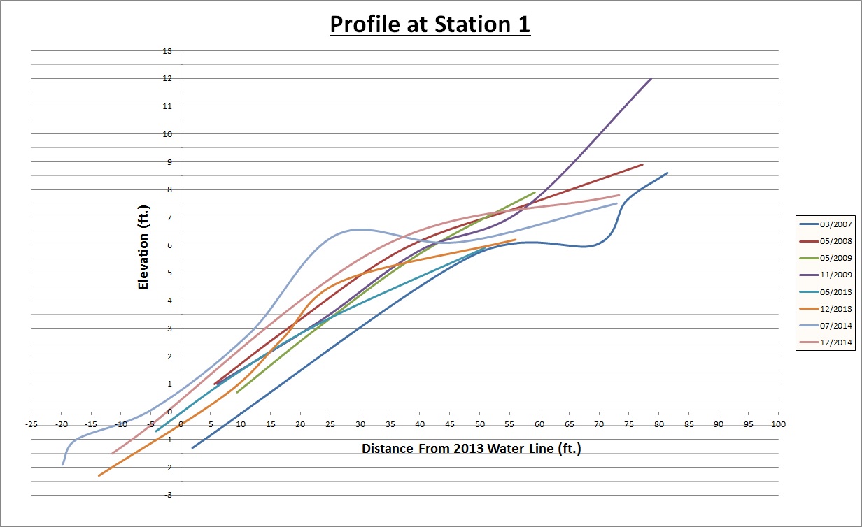
I am interested in opinions on how I can create a single graph to display 3D polylines (whether in arcgis or excel) not by using the start point of each line as '0' distance, but by an offset from a 0 point (in this case a water line). I have multiple beach profiles but they all have unique starting points (see attached). I would like to somehow graph so that at 5 feet up the beach from the waterline (not their respective starting points) all lines can be compared for elevation. I can't figure out how best to accomplish this.
Really appreciate any insight on this.
Jeremy
- Mark as New
- Bookmark
- Subscribe
- Mute
- Subscribe to RSS Feed
- Permalink
- Report Inappropriate Content
Unfortunately, the best way I know how to do this in ArcMap requires a ridiculous number of steps. You'd want to convert your lines into routes so you can assign M values (stationing). You'll measure from the waterline to the start point of the line and use that to assign the start measure in the "Make Route" dialog. Then you will need to follow these steps: 39229 - Create a profile graph and show it in multiple colors based on line segments to use the Z and M values so that each graph uses the M values for the horizontal axis. You'll use "Add" in Graph properties to stack all your graphs together.
Best of luck!
- Mark as New
- Bookmark
- Subscribe
- Mute
- Subscribe to RSS Feed
- Permalink
- Report Inappropriate Content
Thanks a lot for the reply Bond. I ended up doing something similar yesterday with just setting an 'offset' distance from each start point to the waterline and adding them (sometimes negative) to the points along each line that had 'distance along line' with associated elevation values. Then exported the dbase table to excel for the better graphing options. Attached is a quick example. Thanks again!