Preview of 3D Tools for Power lines

6537
10
02-19-2019 09:56 PM
Gert_van_Maren
Esri Contributor
6 10 6,537

What are the 3D Tools for Power lines?

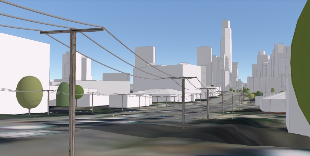
The 3D Tools for Power lines solution is a collection of ArcGIS Pro tools that simplifies and automates the process of creating 3D visualizations of transmission and distribution lines. The results can be published and visualized in a 3D scene which can be easily shared with stakeholders or the public.


Benefits

The following are some benefits of using 3D Tools for Power lines:

  • Visualize existing power lines in 3D and add them to your 3D basemap to serve as a foundation for creating 3D applications and workflows.
  • Visualize proposed power lines in 3D and assess the visual impact on the surrounding landscape.
  • Supports both transmission and distribution lines
  • Works with existing GIS data as input.
  • Creates realistic 3D representations of conductor and tower structures
  • Supports a wide variety of conductor and tower configurations

Austin Power line scene

Get started with 3D Tools for Power lines

  • Download the 3D Tools for Power lines ArcGIS Pro project.
  • Read the current limitations in the description. 
  • Extract the zip file to a folder on your machine.
  • Open the 3DToolsForPowerLines.aprx in ArcGIS Pro.
  • In the Catalog pane, expand the Tasks folder, then double-click on the Create 3D Power Lines task
  • Use the Create 3D Power Lines task to step through the workflow.


System requirements

The following software is required:

  • ArcGIS Pro 2.3 - 2.4 (Advanced)
  • ArcGIS 3D Analyst extension

Note: you might need to install the Microsoft Access Database Engine driver if you encounter a TableToTable error. See this link: https://pro.arcgis.com/en/pro-app/help/data/excel/work-with-excel-in-arcgis-pro.htm

Feedback

It would be helpful for us to know:

  • how these workflows and apps will benefit your organization
  • how the workflows and apps can be improved
  • any bugs or other issues.


For comments, questions, bug reports, new requirements: please email gvanmaren@esri.com

10 Comments
RobertBorchert
Frequent Contributor III

Is there any measurable value to utilizing 3D power lines?  For anything other then gee wiz bling bling?

What I would like to know is what is the ROA for showing power lines in 3D

Gert_van_Maren
Esri Contributor

Hi Robert,


2 use cases for these tools:


1. Conceptual planning of new power lines. What would it look like if you build a power line in a certain location. Then view from different locations. Great for internal stakeholder meetings and public consultation.

2. Visualization of existing power lines for example for a 3D city model. Many cities around the world are building or want to build a digital twin of their city. Power lines are just another layer in the 3D model. (Besides, buildings, trees, underground utilities etc.)


While these tools do not provide engineering grade power lines, the result is a good visual representation based on available input.


Gert

DannyDong
New Contributor III

With the current tools, What structure types do you support? Will I be able to pick different structure types other than lattice tower, and place them on the locations I picked or on the locations specified in a spreadsheet or shapefile? Thanks!

Gert_van_Maren
Esri Contributor

Hi Danny,

Using the tools, you can create different configurations of transmission towers and distribution poles. You can load in an existing point feature layer and use that layer as input into the tools for placement or manually create locations in a new point feature layer.

Regards Gert  

AndresCastillo
MVP Regular Contributor

These 3D power line tools are very useful for modeling for Electric Utilities and their stakeholders.

Great tool.

Good job Esri.

LoKitYeng
New Contributor

Hello Gert,

I can't download the ArcGIS Pro Project from this link : 3D Tools for Power lines ArcGIS Pro project.

LoKitYeng_0-1634723641614.png

Please advice.

Thank you & Best Regard

Gertvan_Maren1
New Contributor III

Hi,

These tools have been integrated into the 3D basemaps solution.

And with the November 2021 release of this solution, we will add the ability to extract power line features from lidar as well as classifying the lidar using deep learning.

Regards Gert

LoKitYeng
New Contributor

Hello Gert,

Can I have the Create Sway Surface for Catenary tool?

Thank you.

Best Regards,
Kit Yeng

Gertvan_Maren1
New Contributor III

Hi,

We are planning to add this tool to the 3D basemaps solution in 2022.

Regards Gert

danielarc
New Contributor II

Unable to download...
How can one access the solution in 2023?

HELP PLEASE