Generation of high-resolution DEM from satellite spotlight-mode SAR
- Subscribe to RSS Feed
- Mark as New
- Mark as Read
- Bookmark
- Subscribe
- Printer Friendly Page
- Report Inappropriate Content
The most recent version of imaging radar, known as spotlight-mode SAR, can produce imagery with spatial resolution that begins to approach that of remote optical imagers.
For all of these reasons, 'airborne' synthetic spotlight aperture radar imaging is rapidly becoming a key technology in the world of modern remote sensing for high-resolution generation of DEM, except for higher cost and different imagery processing workflows (than scan-mode /InSAR or LiDAR).
With the wide use of SPOTLIGHT polarization technology applied to satellite, 'spaceborne' spotlight SAR sensors like COSMO-SkyMed, TerraSAR-X, and TanDEM-X enable us to handle high-resolution stereo-pair HH/ VV SAR images (up to 1-m), to 'accurately & cost-effectively' generate 3-5 m resolution of DEM for large coverage, via the following rigorous workflow.
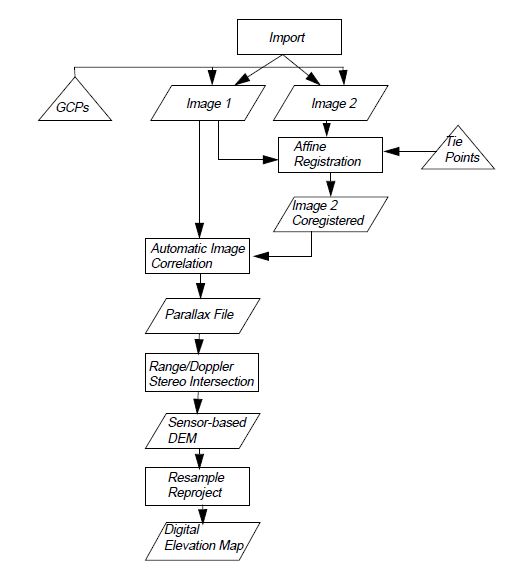
For spotlight-mode SAR imagery registration and processing, refer to the attachement.
++++++++++++++++++++++++
PS.,
The techniques of generating high-resolution DEM (0.15-5 m resolution) are widely discussed and used in operation, including Interferometric Synthetic Aperture Radar (InSAR) and Light Detection and Ranging (LiDAR) along with advancements in the ability to extract elevation data using conventional stereo-pair photogrammetric methods for airborne and spaceborne OPTICAL /near-IR sensors (GeoEye-1, WorldView-2/3, Pleiades-1A/1B, SPOT-6/7, etc.).
Among those, modern airborne & spaceborne imaging radars, known as synthetic 'scan-mode' aperture radars (SARs), are capable of producing high-quality pictures of the earth's surface while avoiding some of the shortcomings of certain other forms of remote imaging systems.
Primarily, radar overcomes the nighttime limitations of optical cameras, and the cloud- cover limitations of both optical and infrared imagers. In addition, because imaging radars use a form of coherent illumination, they can be used in certain special modes such as 'interferometry', to produce some unique derivative image products that 'incoherent' systems cannot.
You must be a registered user to add a comment. If you've already registered, sign in. Otherwise, register and sign in.