- Home
- :
- All Communities
- :
- Industries
- :
- Telecommunications
- :
- Telecommunications Blog
- :
- 5 Things I'm Excited for Post Esri UC 2018
5 Things I'm Excited for Post Esri UC 2018
- Subscribe to RSS Feed
- Mark as New
- Mark as Read
- Bookmark
- Subscribe
- Printer Friendly Page
- Report Inappropriate Content
This year's Esri User Conference showcased a lot of great advancements in GIS technology and brought the vast user community of GIS professionals in telecommunications together. Being a GIS user for 5 years and then working for Esri the past 4 years, I'm always blown away by the energy at the User Conference. This year I wanted to share the top 5 things I'm excited for following the conference. So here we go:
5. ArcGIS Field Solutions
Esri's suite of mobile apps keep on growing in number and improving in capabilities. I am really excited about Survey123, the next generation of Collector, and the new markup capabilities in Explorer.
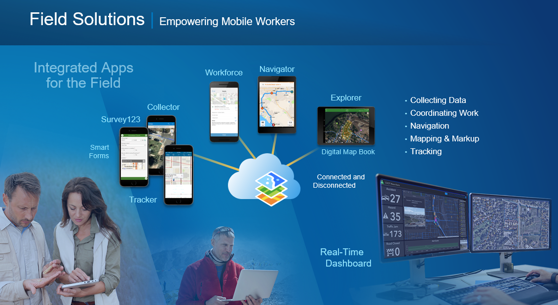
Survey123 for ArcGIS
What I like the most about Survey123 is its form centric approach to data collection. Its more user friendly for those not familiar with a map/GIS based interface. Building these smart forms is also really easy using the web based form builder and desktop based Survey123 Connect, and the new barcode scanner, report template, and photo markup are great additions to this app.
- Spatial Ninja Pro Tips:
Collector for ArcGIS
Collector, the map centric data collection app, was the first ArcGIS mobile app for data collection on iOS and Android. Its been around for quite some time, but I'm really excited about the future release of Collector which has been named 'The Aurora Project'. The Aurora Project release of Collector will finally see Vector Tile and labeling support for web maps used in Collector. You'll also get a brand new, easier to use, interface which allows for quicker data collection.
- Spatial Ninja Pro tips:
Explorer for ArcGIS
Explorer can be thought of as your mobile map book. No longer are the days of printing off large map books, marking them up in the field, and digitizing those edits in the back office. That workflow is completely streamlined and digital now, thanks to the new markup features in Explorer.
- Spatial Ninja Pro Tips:
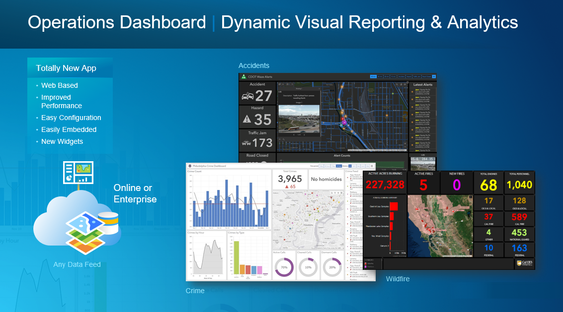
4. The New Operations Dashboard for ArcGIS
I've always been excited for the possibilities and uses of Operations Dashboard, but the app traditionally being a desktop only solution limited its potential. Operations Dashboard has been overhauled and is now completely web based. The builder experience and end dashboard product are both accessible over a web browser. The underlying JavaScript/HTML5 framework also makes the new Operations Dashboard so much more customizable and extendable.
- Spatial Ninja Pro Tips:
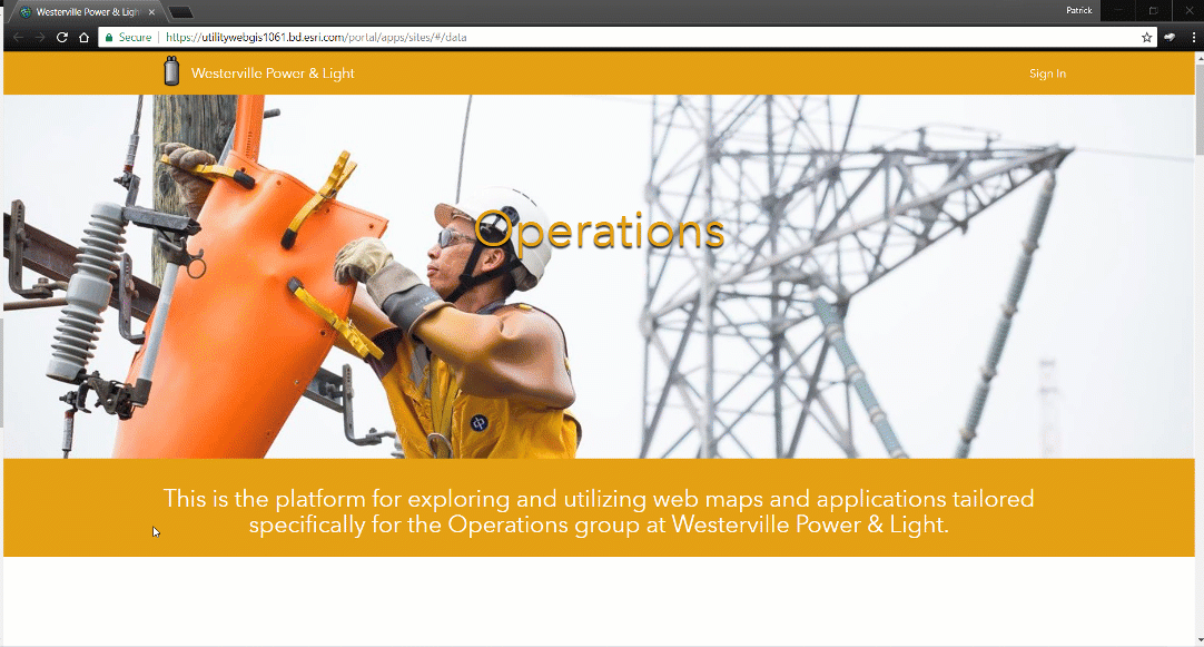
3. ArcGIS Enterprise Sites
Sites are new way to customize a home page for different users of your ArcGIS Enterprise portal. You can now tailor a unique portal experience for different user groups within your organization, presenting to them the maps, apps, and content they most commonly need to perform their day to day job.
- Spatial Ninja Pro Tips:
2. Advancements in Big Data and AI/ML Tools
Esri continues to put the Science of Where to work with their spatial analysis tools. I'm really excited about some of the new big data and AI/ML tools that Esri is building into ArcGIS, especially for use cases around analyzing communications network performance. These tools can now also be accessed in ArcGIS or deployed directly within your big data environments, bringing the analysis to the data.

- Spatial Ninja Pro Tips:
1. GIS's Continued Use as a Complete Platform
The number one thing I'm most excited for following this years User Conference is seeing how ArcGIS continues to be adopted as a platform for all things mapping and location intelligence. For years and years GIS has been seen as only an engineering and design solution or outside plant management solution. But we continue to see the transition of GIS as a platform to not only support infrastructure lifecycle management, but telecommunications planning, fulfillment, and assurance. Its amazing to see our users push ArcGIS to new limits and support more and more departments within their telco with mapping and location intelligence capabilities.

Spatial Ninja Pro Tips:
- GIS and Mapping Platform for Telecommunications Planning, Fulfillment, and Assurance
- Telecommunications
Another User Conference in the books and I can't wait until I get to see everyone again at the GeoConX Conference in the fall.
Patrick Huls
Technical Evangelist - Telecommunications
LinkedIn: Patrick Huls| Twitter: @SpatialNinja| GeoNet:Phuls-esristaff
You must be a registered user to add a comment. If you've already registered, sign in. Otherwise, register and sign in.