- Home
- :
- All Communities
- :
- Products
- :
- ArcGIS Earth
- :
- ArcGIS Earth Questions
- :
- Re: Transparency of viewshed
- Subscribe to RSS Feed
- Mark Topic as New
- Mark Topic as Read
- Float this Topic for Current User
- Bookmark
- Subscribe
- Mute
- Printer Friendly Page
- Mark as New
- Bookmark
- Subscribe
- Mute
- Subscribe to RSS Feed
- Permalink
- Report Inappropriate Content
For historical investigations, I need viewshed analyses of particular panoramic sites. Since a test version of ArcGIS pro / online is not available for non-corona purposes, I tried ArcGIS Earth. Unfortunately the output is too intransparent, whatever color code I select. How can transparency of viewshed be increased? Is viewshed transparency better scalable in ArcGIS pro /online?
Solved! Go to Solution.
Accepted Solutions
- Mark as New
- Bookmark
- Subscribe
- Mute
- Subscribe to RSS Feed
- Permalink
- Report Inappropriate Content
Hey Thomas,
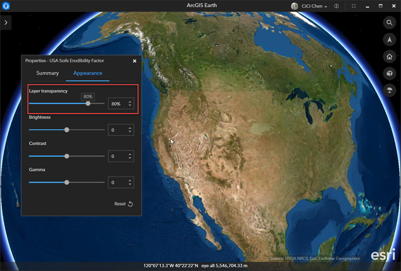
I took the USA Soils Erodibility Factor layer as an example and took a couple of transparency screenshots in ArcGIS Earth with different levels (0%,30%, 50%, and 80%) for your reference. Hope these are helpful.


Thanks,
CiCi
- Mark as New
- Bookmark
- Subscribe
- Mute
- Subscribe to RSS Feed
- Permalink
- Report Inappropriate Content
Hey Thomas,
Thanks for your feedback. Unfortunately, there's no flexibility to adjust the transparency of the viewshed analysis outcome at the moment. This is indeed a good enhancement for viewshed analysis in ArcGIS Earth and will be planned in the future release. If you have layers that are ready to be visualized in ArcGIS Earth, we currently support adjusting layer transparency from layer properties.
In ArcGIS Pro, there's a transparency slider under Appearance that allows users to adjust the transparency of viewshed output raster. You can check the following help documents for more info:
Using Viewshed and Observer Points for visibility analysis—Help | Documentation
Change the appearance of imagery—ArcGIS Pro | Documentation
Hope this helps. Let us know if you have any other questions.
Thanks!
CiCi
- Mark as New
- Bookmark
- Subscribe
- Mute
- Subscribe to RSS Feed
- Permalink
- Report Inappropriate Content
Hi CiCi,
thank you, I appreciate your hints. An upcoming version of Earth with a transparency slider is encouraging.
Now I discovered the procedure in YouTube , too.
Are there sample screenshots available with different levels of transparency?
Best regards,
Thomas
- Mark as New
- Bookmark
- Subscribe
- Mute
- Subscribe to RSS Feed
- Permalink
- Report Inappropriate Content
Hey Thomas,
I took the USA Soils Erodibility Factor layer as an example and took a couple of transparency screenshots in ArcGIS Earth with different levels (0%,30%, 50%, and 80%) for your reference. Hope these are helpful.
Thanks,
CiCi
- Mark as New
- Bookmark
- Subscribe
- Mute
- Subscribe to RSS Feed
- Permalink
- Report Inappropriate Content
Hi CiCi,
thank you so much for your particular commitment! Your screenshots give me a clear idea of the transparency effects possible in ArcGIS. I am waiting impatiently for the 21 days test version to be available for me.
Best,
Thomas