- Home
- :
- All Communities
- :
- User Groups
- :
- Coordinate Reference Systems
- :
- Questions
- :
- Re: No transformation available
- Subscribe to RSS Feed
- Mark Topic as New
- Mark Topic as Read
- Float this Topic for Current User
- Bookmark
- Subscribe
- Mute
- Printer Friendly Page
No transformation available
- Mark as New
- Bookmark
- Subscribe
- Mute
- Subscribe to RSS Feed
- Permalink
- Report Inappropriate Content
Hi,
i am working with various layers that have the following coordinate system and projection:
- Coordinate system: GCS_CAPE
- Projection: Transverse_Mercator
How can I add a base map that is aligned with them? The base maps have the following features :
- Coordinate system: WGS 84
- Projection: WGS 1984 Web Mercator (auxiliary sphere)
Base maps cannot be projected.
When I try to specify a transformation for the data frame (its coordinate system is Transverse Mercator) to enable the alignment 'on-the-fly' of the base map when I add it to the map, I obtain the following message: "A datum transformation cannot be found. The data may draw with an offset". So I cannot choose any transformation,
Please help !
- Mark as New
- Bookmark
- Subscribe
- Mute
- Subscribe to RSS Feed
- Permalink
- Report Inappropriate Content
Hi Marta Bescansa!
I have two questions...
1) Can you provide me the full definition of you Transverse_Mercator coordinate system in GCS_CAPE? Does the coordinate system has an WKID?
2) What version of ArcGIS Pro are you using?
Thanks,
Bojan
- Mark as New
- Bookmark
- Subscribe
- Mute
- Subscribe to RSS Feed
- Permalink
- Report Inappropriate Content
Hi Bojan,
here is the full description
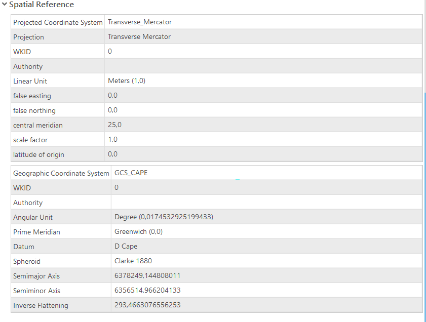
I see that there might be a problem there because the values are 0. I have checked that the projected coordinate systems for Botswana are:

My project is in the Chobe District, which one is it then? And what should I do?
I am working with ArcPro 2.5.2.
Many many thanks,
Marta
- Mark as New
- Bookmark
- Subscribe
- Mute
- Subscribe to RSS Feed
- Permalink
- Report Inappropriate Content
Hi Marta Bescans,
You are missing a transformation, because your definition of GCS_CAPE is a custom definition (WKID is 0). Correct definition is:
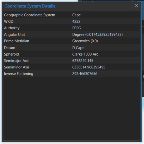
To make it work with a custom GCS, you need to create a custom geographic transformation that transforms your data between a custom GCS and WGS 1984.
For the whole area of the Chobe District, which covers approximately the area between 23.8 and 26 degrees East and 17.78 and 19 degrees South, you should probably use Cape_UTM_Zone_36S, which has the area of use between 21 and 27 degrees East and 17.78 and 26.88 degrees South. You could also use Cape_UTM_Zone_35S since it covers most of the area of the Chobe District.
I hope this helps,
Bojan
- Mark as New
- Bookmark
- Subscribe
- Mute
- Subscribe to RSS Feed
- Permalink
- Report Inappropriate Content
Hi Bojan,
in the end I used the tool 'project' and chose Cape_UTM_Zone_35S for the data. Then I changed the coordinate system of the data frame to Cape_UTM_Zone_35S and everything was aligned! The data looks like this now:

I guess everything is right now. Thank you so much for your help.
Greetings,
Marta