- Home
- :
- All Communities
- :
- Industries
- :
- Education
- :
- Higher Education
- :
- Higher Education Questions
- :
- Re: How to move and Scale a shp.file
- Subscribe to RSS Feed
- Mark Topic as New
- Mark Topic as Read
- Float this Topic for Current User
- Bookmark
- Subscribe
- Mute
- Printer Friendly Page
- Mark as New
- Bookmark
- Subscribe
- Mute
- Subscribe to RSS Feed
- Permalink
- Report Inappropriate Content
So here is the scoop, I am creating a Mod map for A video game called DAYZ, However, the Mapping software it uses only uses UTM ZONE 31N. I need to use existing polygon datasets to populate things like trees but the polygons display in a different location than my terrain, my data is from UTM zone 11 N. Canada. So basically what i need is a algorithm to move and scale the shape files to line up with my height map or DEM in 31 N.
Solved! Go to Solution.
Accepted Solutions
- Mark as New
- Bookmark
- Subscribe
- Mute
- Subscribe to RSS Feed
- Permalink
- Report Inappropriate Content
Hi Joseph,
I am assuming that your data is drawn in Canada (zone 11), and you need it to draw in Europe instead (zone 31)
Using either ArcGIS Pro or ArcMap, you can re-project your data using the Project geoprocessing tool. However, because the extents of those two UTM zones don't overlap, I think you'll need an intermediate step.
Here's what I would try, using ArcGIS Pro. You can do this in ArcMap too, the steps will be similar.
1. Use the Project tool to convert your data into a coordinate system with a global extent, for example WGS 1984.
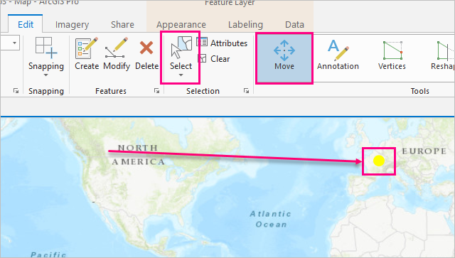
2. Use the editing tools to select your newly projected data and move it to Europe.
3. Clear the selection and save your edits.
4. Use the Project tool to convert your newly projected data to UTM Zone 31N.

There's a few coordinate system options for this UTM zone, each uses a different datam. I don't know if it matters for your end purpose which datum you use. if you're not sure, try WGS_1984_UTM_Zone_31N first.
notes:
data type: the Project tool will save a feature class output, in the project's default geodatabase. If you really need it to be a shapefile instead, you can browse to a folder location like your desktop, and it will create a shapefile there. or you can use the Copy Features tool afterwards to convert the feature class.
Geographic transformations: if you don't see any options in the drop down, you don't need one. if you do see options, pick the first one in the list.
There are editing tools for scaling your data as well, but I'm not the best person to help you with that. I would say getting your data in the right place would be the first step.
- Mark as New
- Bookmark
- Subscribe
- Mute
- Subscribe to RSS Feed
- Permalink
- Report Inappropriate Content
Hi Joseph,
I am assuming that your data is drawn in Canada (zone 11), and you need it to draw in Europe instead (zone 31)
Using either ArcGIS Pro or ArcMap, you can re-project your data using the Project geoprocessing tool. However, because the extents of those two UTM zones don't overlap, I think you'll need an intermediate step.
Here's what I would try, using ArcGIS Pro. You can do this in ArcMap too, the steps will be similar.
1. Use the Project tool to convert your data into a coordinate system with a global extent, for example WGS 1984.
2. Use the editing tools to select your newly projected data and move it to Europe.
3. Clear the selection and save your edits.
4. Use the Project tool to convert your newly projected data to UTM Zone 31N.
There's a few coordinate system options for this UTM zone, each uses a different datam. I don't know if it matters for your end purpose which datum you use. if you're not sure, try WGS_1984_UTM_Zone_31N first.
notes:
data type: the Project tool will save a feature class output, in the project's default geodatabase. If you really need it to be a shapefile instead, you can browse to a folder location like your desktop, and it will create a shapefile there. or you can use the Copy Features tool afterwards to convert the feature class.
Geographic transformations: if you don't see any options in the drop down, you don't need one. if you do see options, pick the first one in the list.
There are editing tools for scaling your data as well, but I'm not the best person to help you with that. I would say getting your data in the right place would be the first step.
- Mark as New
- Bookmark
- Subscribe
- Mute
- Subscribe to RSS Feed
- Permalink
- Report Inappropriate Content
THANKYOU!!! this worked like a charm, sorry late reply, i forgot i posted this!