- Home
- :
- All Communities
- :
- Products
- :
- ArcGIS Pro
- :
- ArcGIS Pro Questions
- :
- Beginner struggling with proximity analysis
- Subscribe to RSS Feed
- Mark Topic as New
- Mark Topic as Read
- Float this Topic for Current User
- Bookmark
- Subscribe
- Mute
- Printer Friendly Page
Beginner struggling with proximity analysis
- Mark as New
- Bookmark
- Subscribe
- Mute
- Subscribe to RSS Feed
- Permalink
- Report Inappropriate Content
Hi everyone, I'm new to GIS and I'm in over my head. I'm hoping someone might be able to point me in the right direction. I'm working with municipal parcels and need to perform some proximity analysis:
- Number of parcels zoned residential that are adjacent to, or within X units of distance from, parcels zoned industrial. This is a polygon shape file with no need for reference to another data source.
- Number of parcels zoned residential that face streets with certain street attributes (posted speed limit, if it's a hazardous waste route, etc). This requires the parcel shape file mentioned above but also a second shape (line) file which contains these street features.
- Is there a way to easily identify parcels on corners (at intersections)?
I've spent hours online looking for solutions but I haven't had any success so far. I had assumed this type of analysis would be relatively easy for me but either I'm wrong or my search skills are lacking. I've read about proximity analysis and polygon neighbors, and I'm still stumped.
If anyone could point me in the right direction, that would be greatly appreciated.
Thanks,
Sarah
- Mark as New
- Bookmark
- Subscribe
- Mute
- Subscribe to RSS Feed
- Permalink
- Report Inappropriate Content
Hi Sarah,
If it's a one-off task (or at least something that doesn't need to be automated for batch runs) I'd be using simple 'select by location' and 'select by attribute'.
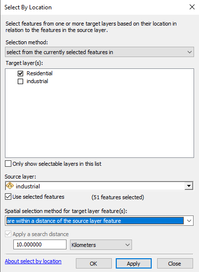
1. Add your parcel layer twice to a project in ArcMap (or ArcGIS Pro). In the first layer select all industrial parcels. In the second select all residential parcels. Then run select by location on the second layer relative to the first layer - make sure to click 'select from currently selected features', 'Use selected features' tick box, and enter the search distance. This should return the features you want as selections. Look for the count at the table.
2. You'll have to assume that 'face the street' means that they are within a certain distance from your street layer. Basically repeat the above: select streets that have certain attributes (e.g. speed limit), and then search by location for parcels within a distance from these selected streets.
3. Convert your intersections to points (e.g. ArcGIS 10.2 - Intersect - Extract intersection points of lines - YouTube ). Then run 'select by location' - select every parcel which is at x distance from your intersection points.
Hope this helps,
Uri
If this answer solved your question or if you found it helpful please mark it accordingly to help others who have the same question.
- Mark as New
- Bookmark
- Subscribe
- Mute
- Subscribe to RSS Feed
- Permalink
- Report Inappropriate Content
Uri, thank you SO MUCH for your reply. I will try to implement today and will let you know how it goes.
Thanks again and stay safe.