- Home
- :
- All Communities
- :
- Products
- :
- ArcGIS Spatial Analyst
- :
- ArcGIS Spatial Analyst Questions
- :
- Using arcpy to create slope surfaces
- Subscribe to RSS Feed
- Mark Topic as New
- Mark Topic as Read
- Float this Topic for Current User
- Bookmark
- Subscribe
- Mute
- Printer Friendly Page
Using arcpy to create slope surfaces
- Mark as New
- Bookmark
- Subscribe
- Mute
- Subscribe to RSS Feed
- Permalink
- Report Inappropriate Content
ArcGIS Pro 2.5
I have a number of .tif and ,img images that I need to convert into slope surfaces (as discussed here Display A Slope Raster ) and have been following the steps shown here: Slope—Help | Documentation .
However, I get one of two errors depending on where I send the slope.save() to. Here is my script:
import arcpy
from arcpy.sa import *
import os
inDir = r'C:\JoesStuff\SouthernImages'
#outWS = r'C:\JoesStuff\SouthernImages\SlopeRasters' # to a folder
outWS = r'C:\JoesStuff\SouthernImages\Rasters.gdb' # to a gdb
for i in os.listdir(inDir):
if i.endswith('.tif') or i.endswith('.img'):
inRaster = os.path.join(inDir,i)
outFile = i.split('.')[0]
outRaster = f'{outWS}\{outFile}Slope'
outMeasurement = 'PERCENT_RISE'
zFactor = 1
method = 'PLANAR'
zUnit = 'METER'
outSlope = Slope(inRaster, outMeasurement, zFactor, method, zUnit)
outSlope.save(outRaster)with line 6 commented and line 7 active this error is returned:
RuntimeError: ERROR 010240: Could not save raster dataset to
C:\JoesStuff\SouthernImages\Rasters.gdb\12TVK1276Slope with output format FGDBR.if I try to save the slope to a directory by executing line 6 with line 7 commented this error is returned
RuntimeError: ERROR 010240: Could not save raster dataset to
C:\JoesStuff\SouthernImages\SlopeRasters\12TVK1276Slope with output format GRID.I know the slope surfaces are being created, because when I comment line 20, and replace it with a print statement, the loop runs just fine. I have run tool manually and it works just great on individual input .tif or .img.
- Mark as New
- Bookmark
- Subscribe
- Mute
- Subscribe to RSS Feed
- Permalink
- Report Inappropriate Content
the other thread isn't closed
*.tif is the preferred raster format, so the destination of the raster should be a compliant folder path
- Mark as New
- Bookmark
- Subscribe
- Mute
- Subscribe to RSS Feed
- Permalink
- Report Inappropriate Content
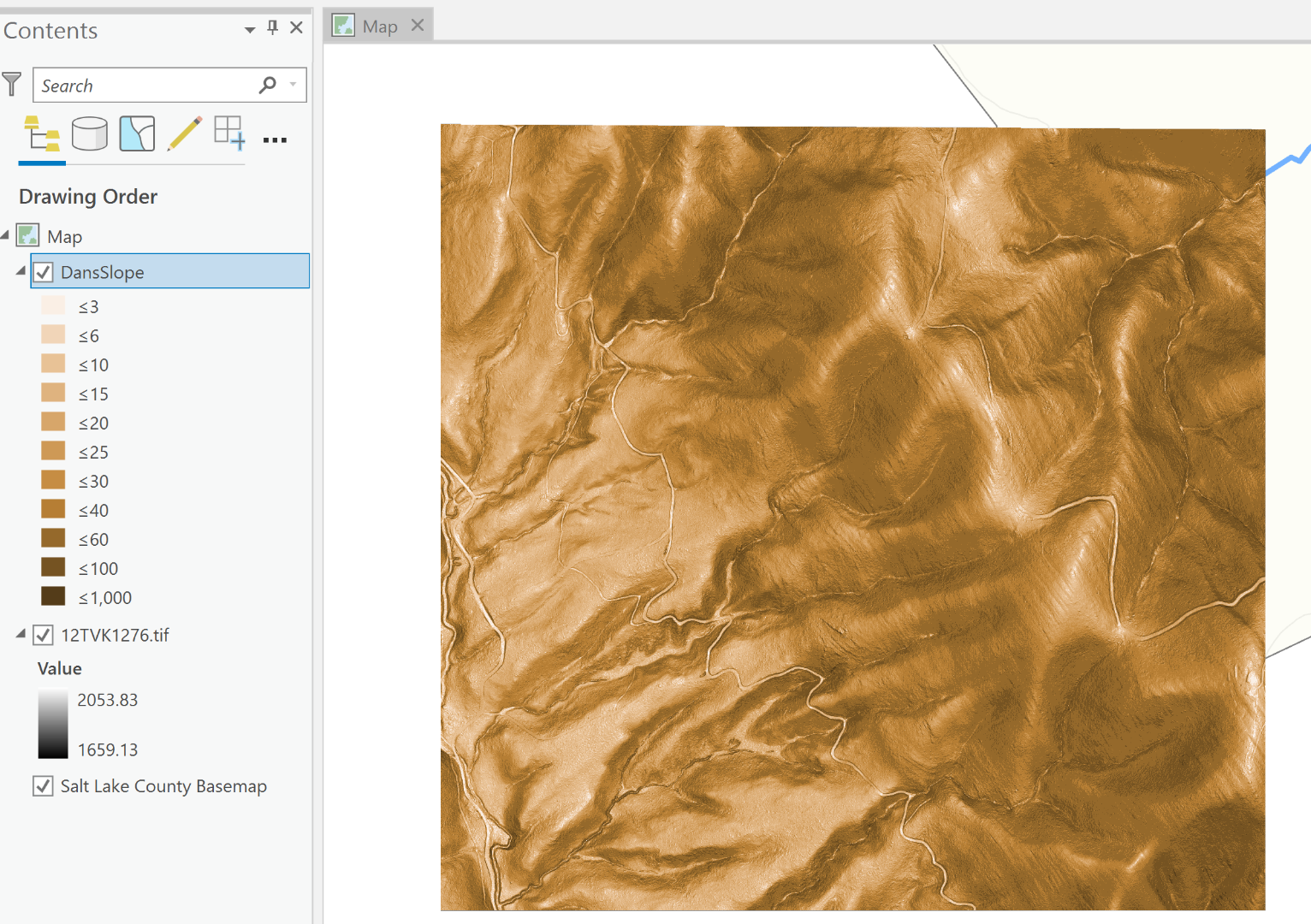
As mentioned, when I run the tool manually, all is good:
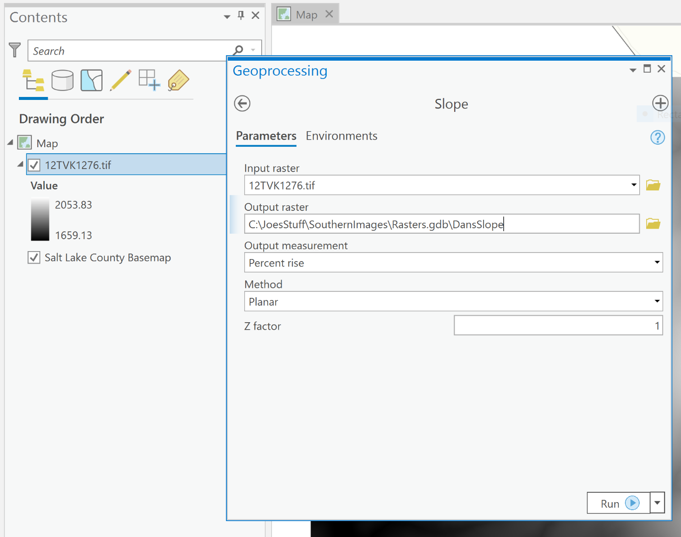
Note the values used by default in the symbology: I'm not sure what was going on when I created the slope surfaces mentioned in the other thread getting the values that were nonsensical (to me). These values are what I expect:
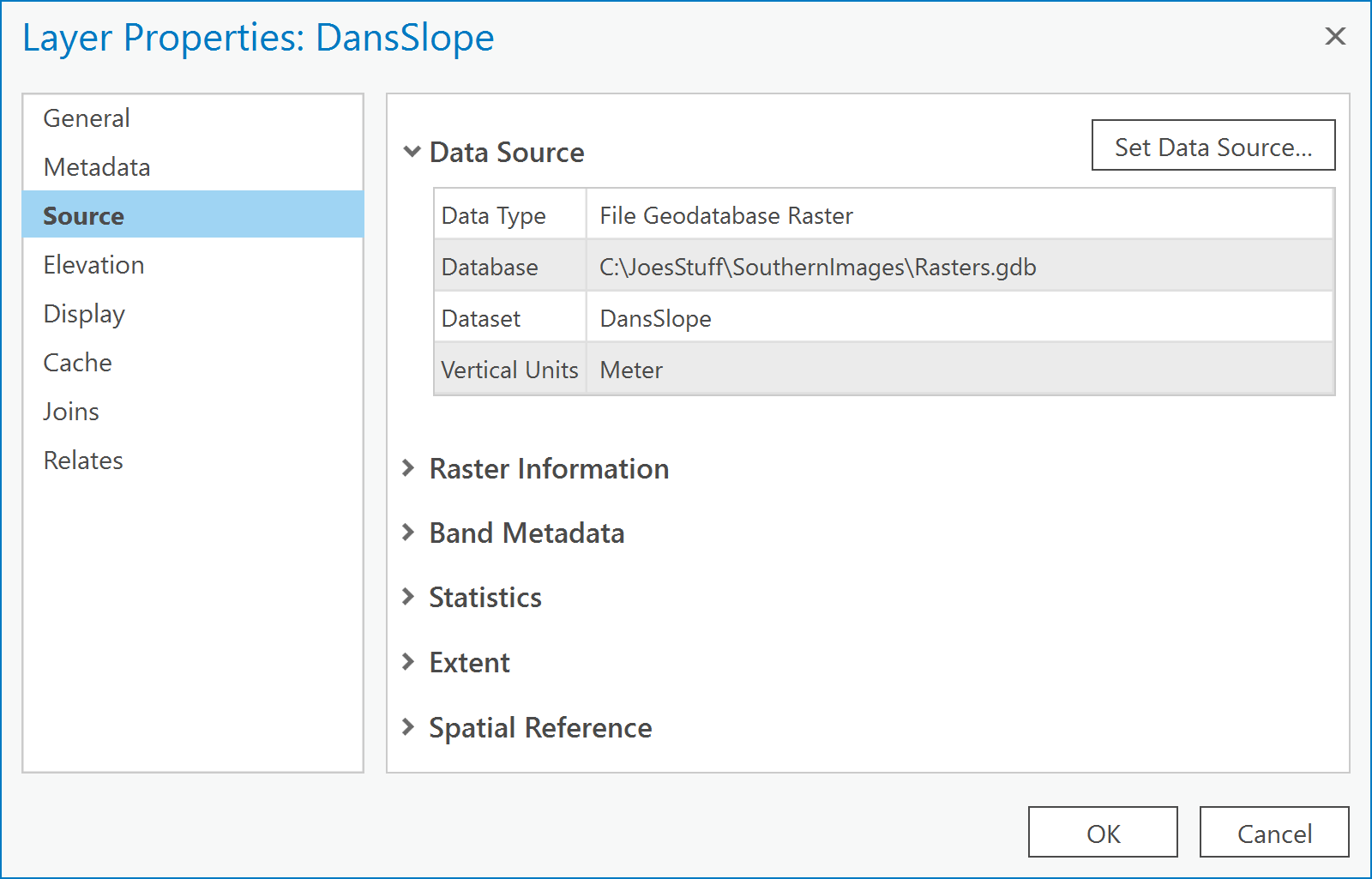
Looks like DansSlope is a good ol' FGDBR type, right?
- Mark as New
- Bookmark
- Subscribe
- Mute
- Subscribe to RSS Feed
- Permalink
- Report Inappropriate Content
*tif is all I use for rasters, I don't even use esri grids anymore and the last thing I would want is for my work to be tied up in a fgdb if I had to use it somewhere else that can't read fgdb . With *.tif, I can look at in image software, process it in python, numpy etc. even esri recommends tif (buried in the help,).
symbology is after the fact.
- Mark as New
- Bookmark
- Subscribe
- Mute
- Subscribe to RSS Feed
- Permalink
- Report Inappropriate Content
Let me give that a try: slope.save(C:\path\to\DansSlope.tif), right?
- Mark as New
- Bookmark
- Subscribe
- Mute
- Subscribe to RSS Feed
- Permalink
- Report Inappropriate Content
the reason the "grid" format failed... you can't have esri grids begin with a number
- Mark as New
- Bookmark
- Subscribe
- Mute
- Subscribe to RSS Feed
- Permalink
- Report Inappropriate Content
...and a "grid" name cannot exceed 13 characters.
- Mark as New
- Bookmark
- Subscribe
- Mute
- Subscribe to RSS Feed
- Permalink
- Report Inappropriate Content
Okay: got it wired using both of your suggestions. Here's the final script
import arcpy
from arcpy.sa import *
import os
inDir = r'C:\JoesStuff\SouthernImages'
#outWS = r'C:\JoesStuff\SouthernImages\SlopeRasters' # to a folder
outWS = r'C:\JoesStuff\SouthernImages\Rasters.gdb' # to a gdb
imageList = ['C:\\JoesStuff\\SouthernImages\\12TVK1276.tif',
'C:\\JoesStuff\\SouthernImages\\12TVK1474.tif',
'C:\\JoesStuff\\SouthernImages\\12TVK1476.tif',
'C:\\JoesStuff\\SouthernImages\\12TVK1674.tif',
'C:\\JoesStuff\\SouthernImages\\12TVK1676.tif',
'C:\\JoesStuff\\SouthernImages\\12TVK1874.tif',
'C:\\JoesStuff\\SouthernImages\\12TVK1876.tif',
'C:\\JoesStuff\\SouthernImages\\12TVK1877.tif',
'C:\\JoesStuff\\SouthernImages\\12TVK1976.tif',
'C:\\JoesStuff\\SouthernImages\\12TVK1977.tif',
'C:\\JoesStuff\\SouthernImages\\hh12TVK1200076000.img',
'C:\\JoesStuff\\SouthernImages\\hh12TVK1200078000.img',
'C:\\JoesStuff\\SouthernImages\\hh12TVK1400076000.img',
'C:\\JoesStuff\\SouthernImages\\hh12TVK1400078000.img',
'C:\\JoesStuff\\SouthernImages\\hh12TVK1600076000.img',
'C:\\JoesStuff\\SouthernImages\\hh12TVK1600078000.img',
'C:\\JoesStuff\\SouthernImages\\hh12TVK1800074000.img',
'C:\\JoesStuff\\SouthernImages\\hh12TVK1800076000.img',
'C:\\JoesStuff\\SouthernImages\\hh12TVK1800078000.img']
for i in enumerate(imageList):
inRaster = i[1]
outName = f'Slope{i[0]}' # f'Slope{i[0]}.tif'
outRaster = f'{outWS}\{outName}'
outMeasurement = 'PERCENT_RISE'
zFactor = 1
method = 'PLANAR'
zUnit = 'METER'
outSlope = Slope(inRaster, outMeasurement, zFactor, method, zUnit)
outSlope.save(outRaster)I read an article earlier today suggesting enumerate() instead of range() in a for loop and went that route. Line 33
can go to an FGDB grid or TIF image depending on which line (6 or 7) is executed.
So in essence you both answered my question so I'll let you duke it out for bragging rights and just assign it 'Assumed Answered'... 
- Mark as New
- Bookmark
- Subscribe
- Mute
- Subscribe to RSS Feed
- Permalink
- Report Inappropriate Content
In anticipation of your next question....
Then I suppose I shouldn't tell you what happens if you do the spyder 4.1 update and let you figure it out on your own 
- Mark as New
- Bookmark
- Subscribe
- Mute
- Subscribe to RSS Feed
- Permalink
- Report Inappropriate Content
Actually the laptop I'm using has spyder 3.3 on it since I just went with what ships with Pro 2.5; remember I'm home practicing good social distancing. My desktop back at the office has a spyder 3.3 env as well as spyder 4.0 env; I have some packages I use that would have downgraded the 4.0 env so now I have two. Sounds like I may have three once I'm back there.....
(you're not even gonna give me a hint?)