- Home
- :
- All Communities
- :
- Products
- :
- ArcGIS Survey123
- :
- ArcGIS Survey123 Questions
- :
- Re: Feature Report - displaying photo locations
- Subscribe to RSS Feed
- Mark Topic as New
- Mark Topic as Read
- Float this Topic for Current User
- Bookmark
- Subscribe
- Mute
- Printer Friendly Page
- Mark as New
- Bookmark
- Subscribe
- Mute
- Subscribe to RSS Feed
- Permalink
- Report Inappropriate Content
In a Feature Report how do I/can I, display the location of photos that are in a repeat in the Survey. I have a Survey when they open it, they are asked a few general question, then given the option to take as many photos as needed (a repeat). Each photo can have diffrent X, Y, values that differ from the survey point itself. I would like to display the photo locations in a map in the Feature Report.
Solved! Go to Solution.
Accepted Solutions
- Mark as New
- Bookmark
- Subscribe
- Mute
- Subscribe to RSS Feed
- Permalink
- Report Inappropriate Content
Hi Benjamin
This could be achieved by adding a geopoint question to the repeat. This would make the repeat a related point feature layer (as opposed to a related table) that can store a location for each repeat record. You would then be able to show an individual map in your feature report for each photo.
Best,
Jim
- Mark as New
- Bookmark
- Subscribe
- Mute
- Subscribe to RSS Feed
- Permalink
- Report Inappropriate Content
Thanks for the Idea, can you provide an example of what you meen
- Mark as New
- Bookmark
- Subscribe
- Mute
- Subscribe to RSS Feed
- Permalink
- Report Inappropriate Content
Hi Benjamin
Here I've added a geopoint question to your repeat:
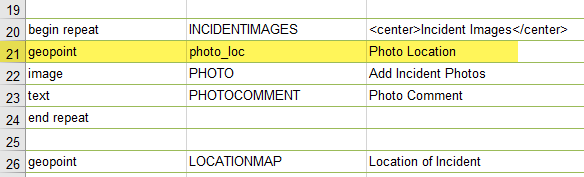
Then add the ${photo_loc} placeholder to your report template (inside the repeat section). This will show the map for each repeat. If required, you could make this geopoint question read-only, so it will take the device's location and the user will not be able to open the map to modify the location. You can also use the size parameter for map questions to control the dimensions of the map (similar to photos), as well as mapSettings to use a specific web map and optionally specify a scale. More info on this here: Feature report templates—Survey123 for ArcGIS | Documentation
Hope this helps
Best,
Jim
- Mark as New
- Bookmark
- Subscribe
- Mute
- Subscribe to RSS Feed
- Permalink
- Report Inappropriate Content
Thank you Jim,
That worked great for a map showing each individual photo. How/can I add a overview map that shows all of the photo/geo points.
- Mark as New
- Bookmark
- Subscribe
- Mute
- Subscribe to RSS Feed
- Permalink
- Report Inappropriate Content
Hi Benjamin
With the mapSettings parameters you can specify a web map for a geopoint question via the web map's item ID (as mentioned above). You could make a web map that shows all parent and related point features and symbolise these accordingly, and then use this web map in your feature report. One thing to keep in mind is that ALL features that are visible in the web map could also be shown in the feature report, depending on the scale and extent of the map in the report. In other words, you might see points on the map that are not relevant to the current survey response. If each survey response (and its photo points) is spatially separate from all other responses, this might not be an issue - you could use a scale large enough to avoid seeing the other points.
There isn't a method in the feature report template for showing only the relevant features in one map. One workaround would be to filter the features in the web map itself before producing the report; however you would need to do this manually for each survey response.
Best,
Jim