- Home
- :
- All Communities
- :
- Products
- :
- ArcGIS Online
- :
- ArcGIS Online Questions
- :
- Re: Layers missing in "Manage Offline Areas" for w...
- Subscribe to RSS Feed
- Mark Topic as New
- Mark Topic as Read
- Float this Topic for Current User
- Bookmark
- Subscribe
- Mute
- Printer Friendly Page
Layers missing in "Manage Offline Areas" for web map configuration
- Mark as New
- Bookmark
- Subscribe
- Mute
- Subscribe to RSS Feed
- Permalink
- Report Inappropriate Content
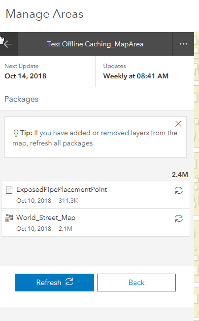
I have a web map that has a hosted feature layer and a layer from a feature service I've published from my ArcGIS server (10.6.1). When I create an offline areas using the Manage offline areas tool, the hosted layer and the basemap show up as cached, but the feature service layer is just missing.
It seems to create just fine if I download an ad hoc area from Collector or Collector Aurora.
Anyone else have this problem or are aware of a limitation of the pre-defined offline caches?
Solved! Go to Solution.
- Mark as New
- Bookmark
- Subscribe
- Mute
- Subscribe to RSS Feed
- Permalink
- Report Inappropriate Content
Update, January of 2020. The problem with the AGOL Manage Areas tool still exists. I filed case number 02452505 about this issue.
To get around this issue, I found that using Collector Classic (19.0.2) is preferable over the newer version of Collector (19.2.0) for downloading offline areas. The Add Offline Areas tool within the newer version of Collector combines the extent and level of detail. This makes the download much larger than it needs to be. Collector Classic allows separate control of extent and level of detail so I end up with a download that is reasonably sized.
- Mark as New
- Bookmark
- Subscribe
- Mute
- Subscribe to RSS Feed
- Permalink
- Report Inappropriate Content
Hi Paul -- One thing I wanted to let you know. You mention
The Add Offline Areas tool within the newer version of Collector combines the extent and level of detail. This makes the download much larger than it needs to be. Collector Classic allows separate control of extent and level of detail so I end up with a download that is reasonably sized.
This isn't accurate. When adding an offline area in the newer version of Collector you are still able to specify a level of detail (if you are using a raster tile layer in your map -- it's not necessary for vector tile layers). It is just done differently. Instead of two separate screens (one for the extent and one for the level of detail), there is now one. At the bottom of that one, if your map has a raster tile layer in it, you'll be about to change the level of detail by clicking on the currently set level of detail (in the image below, you'd click on "Room"):
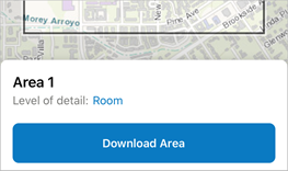
You can read more about this in the Collector help: Define and download a map area in Collector, Step 4 [Prepare for offline data collection]—Collector ...
- Mark as New
- Bookmark
- Subscribe
- Mute
- Subscribe to RSS Feed
- Permalink
- Report Inappropriate Content
Is there a way to check the status of this BUG (BUG-000118112). I have a group of 5 staff working with Collector which is based on a map of ~10 hosted feature layers developed primarily from ESRI feature templates over the past year but a few were added into the web map as a .zip file and then published and then also from Content at "add item". We have finally completed populating the layers with our data and were ready to implement field work with offline maps and successfully ran a few trials which worked fabulously. Now, for one user none of the hosted feature layers from the web map are drawing when trying to add a new offline area in "manage areas". We work in a large area of Florida, so it is difficult to guess as the area needed for the offline map. This problem is not consistent between users. Oddly enough, the features do draw when the offline area is opened in Collector on the notepad. I'm not convinced "add item" is the problem. Is there any solution or guess as to the problem? Thank you! Kristal Walsh, Florida Fish and Wildlife Conservation Commission, Biologist
Office of Conservation Planning
- Mark as New
- Bookmark
- Subscribe
- Mute
- Subscribe to RSS Feed
- Permalink
- Report Inappropriate Content
Hi Kristal,
The Tech Support website (BUG-000118112: The Manage Area tool in ArcGIS Online does not work .. ) lists this bug as resolved at Server version 10.8. If you are still hitting problems and you are at 10.8 or higher I'd suggest reaching out to support to get that looked into.
Regards,
Alan
- Mark as New
- Bookmark
- Subscribe
- Mute
- Subscribe to RSS Feed
- Permalink
- Report Inappropriate Content
Thank you, Alan, but I am not publishing from ArcGIS Server. We normally publish from desktop or from ESRI feature templates. I didn't know of the resolution although I did try to find it. Thank you for this! I will follow up with support. Kristal
Office of Conservation Planning
- Mark as New
- Bookmark
- Subscribe
- Mute
- Subscribe to RSS Feed
- Permalink
- Report Inappropriate Content
Alan Rex is there another step I should take to get this issue Comment Manage Areas Tool BUG 000118112
to Tech Support? I have shared this post to the Tech Support group. I don't think I have the ability to just call them because I am not an administrator for my organization. After 5 days, I've received no replies. Thank you for your assistance, Kristal
Office of Conservation Planning
- Mark as New
- Bookmark
- Subscribe
- Mute
- Subscribe to RSS Feed
- Permalink
- Report Inappropriate Content
Hi Kristal,
I don't actually work in Tech Support anymore so I can't make a case for you directly, but I'll ping some of my old colleagues and see if we can't get you set up with a courtesy case or figure out who your org's authorized support caller is so we can have someone look into this.
-Alan
- Mark as New
- Bookmark
- Subscribe
- Mute
- Subscribe to RSS Feed
- Permalink
- Report Inappropriate Content
Thanks, Alan! Often I post messages and don’t get any replies so I’m wondering if I’m posting to the right places. Our AGOL person in the agency has been emailed also but he handles all of Florida so it’s tough to get timely responses consistently. Appreciate the note. Kristal
Kristal C Walsh, MS
Biological Scientist IV
Office of Conservation Planning Services
Division of Habitat and Species Conservation
Milton, Florida 32571
(850) 851-8065
Office of Conservation Planning
- Mark as New
- Bookmark
- Subscribe
- Mute
- Subscribe to RSS Feed
- Permalink
- Report Inappropriate Content
Hi Kristal, I am one of Alan's colleagues in Esri Support. I noticed you are an authorized caller. Can I go ahead and get a case started up for you so an analyst can take a closer look at this?
Best,
-Peter
- « Previous
-
- 1
- 2
- Next »
- « Previous
-
- 1
- 2
- Next »