- Home
- :
- All Communities
- :
- User Groups
- :
- 911 GIS
- :
- Questions
- :
- Re: Project Raster Error: The operation was attemp...
- Subscribe to RSS Feed
- Mark Topic as New
- Mark Topic as Read
- Float this Topic for Current User
- Bookmark
- Subscribe
- Mute
- Printer Friendly Page
Project Raster Error: The operation was attempted on an empty geometry
- Mark as New
- Bookmark
- Subscribe
- Mute
- Subscribe to RSS Feed
- Permalink
- Report Inappropriate Content
Hi Everyone,
I downloaded the data for the Global Lithological Map (GLiM) Data base. I projected the raster in its native projection of Eckert IV (World) per Hartmann and Moosdorf, 2012; and I need to project the raster into WGS_1984_UTM_Zone_11N and also change the cell size to 250. I keep getting this error. I am not sure how to go about correcting this error. When I downloaded the data the file name has an extension glim_wgs84_0point5.txt.asc and I thought converting the ACSII to ESRI Grid would help but that didn't work. I tried repairing the geometry but the file isn't available for me to select. I am stuck and not sure what to do.
Help me!
Raster Data:
http://dx.doi.org/10.1594/PANGAEA.78853
Solved! Go to Solution.
Accepted Solutions
- Mark as New
- Bookmark
- Subscribe
- Mute
- Subscribe to RSS Feed
- Permalink
- Report Inappropriate Content
The original data isn't in Eckert IV, but straight latitude-longitude decimal degrees. Try defining it as the geographic coordinate system 4326 (WGS 1984).
Melita
- Mark as New
- Bookmark
- Subscribe
- Mute
- Subscribe to RSS Feed
- Permalink
- Report Inappropriate Content
ASCII to Raster—Conversion toolbox | ArcGIS Desktop I would choose *.tif as the raster format
Make sure it has a properly defined coordinate system. If not, use the Define Projection to set the initial coordinate system (not the one you want!, but what it is
Project Raster—Data Management toolbox | ArcGIS Desktop assuming that you used this for the projection.
Repair geometry is only for vector data, you have raster data
- Mark as New
- Bookmark
- Subscribe
- Mute
- Subscribe to RSS Feed
- Permalink
- Report Inappropriate Content
Hi Dan,
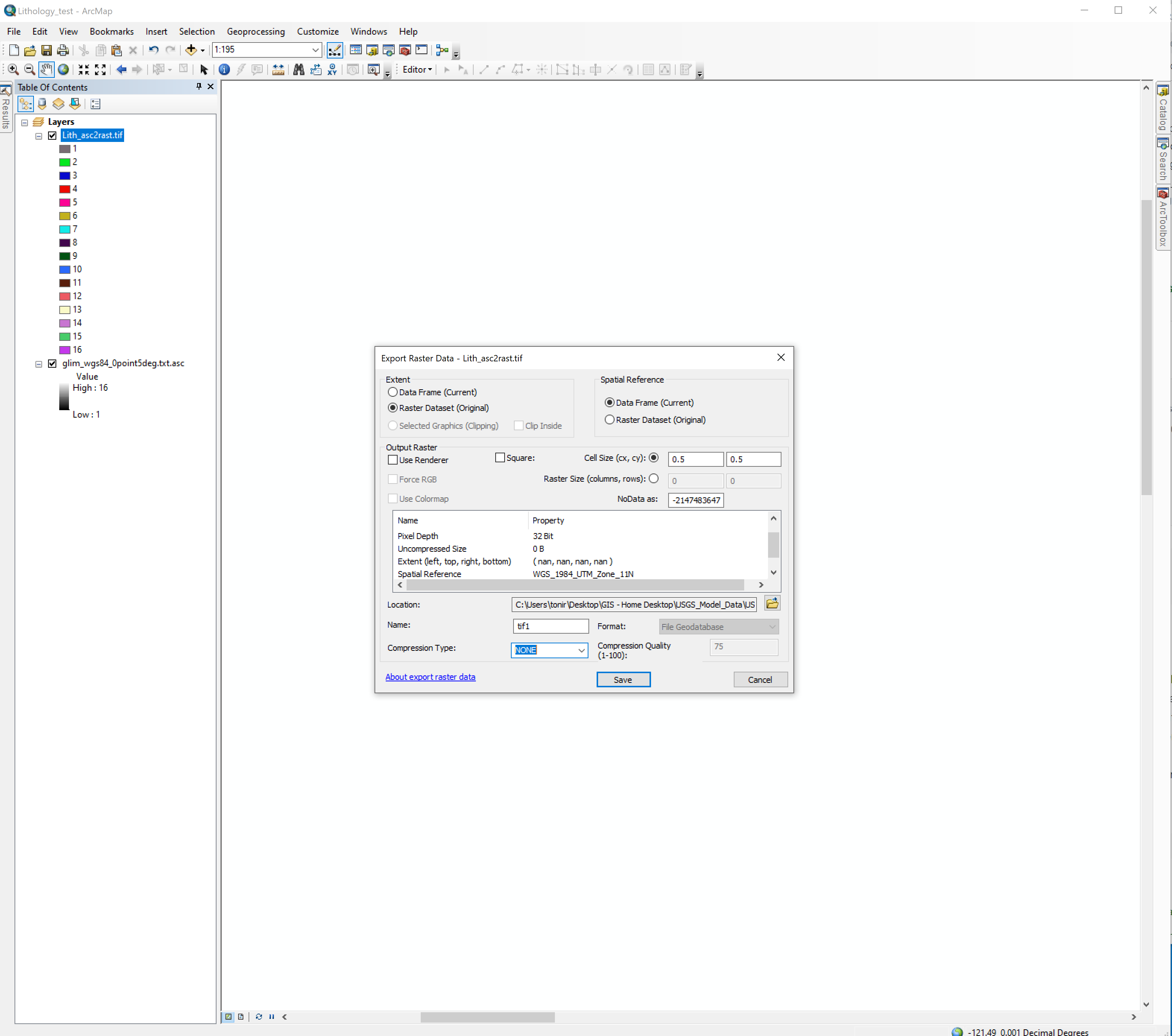
Just gave this a try and was able to convert to .tif ext but still ran into the issue with projecting the raster to WGS_1984_UTM_Zone_11N and getting the empty geometry error. So in the process of attempting a work around by setting my data frame to WGS_1984_UTM_Zone_11N and then Exporting the raster and saving it in that projection. I noticed the Extent changed from (-180.0000, 90.0000, 180.0000, -90.0000) to (nan, nan, nan, nan,), when I changed the spatial reference. I've attached screen shots if that helps. I am assuming this might be the reason I am running into this error. Any advice?
Best,
Toni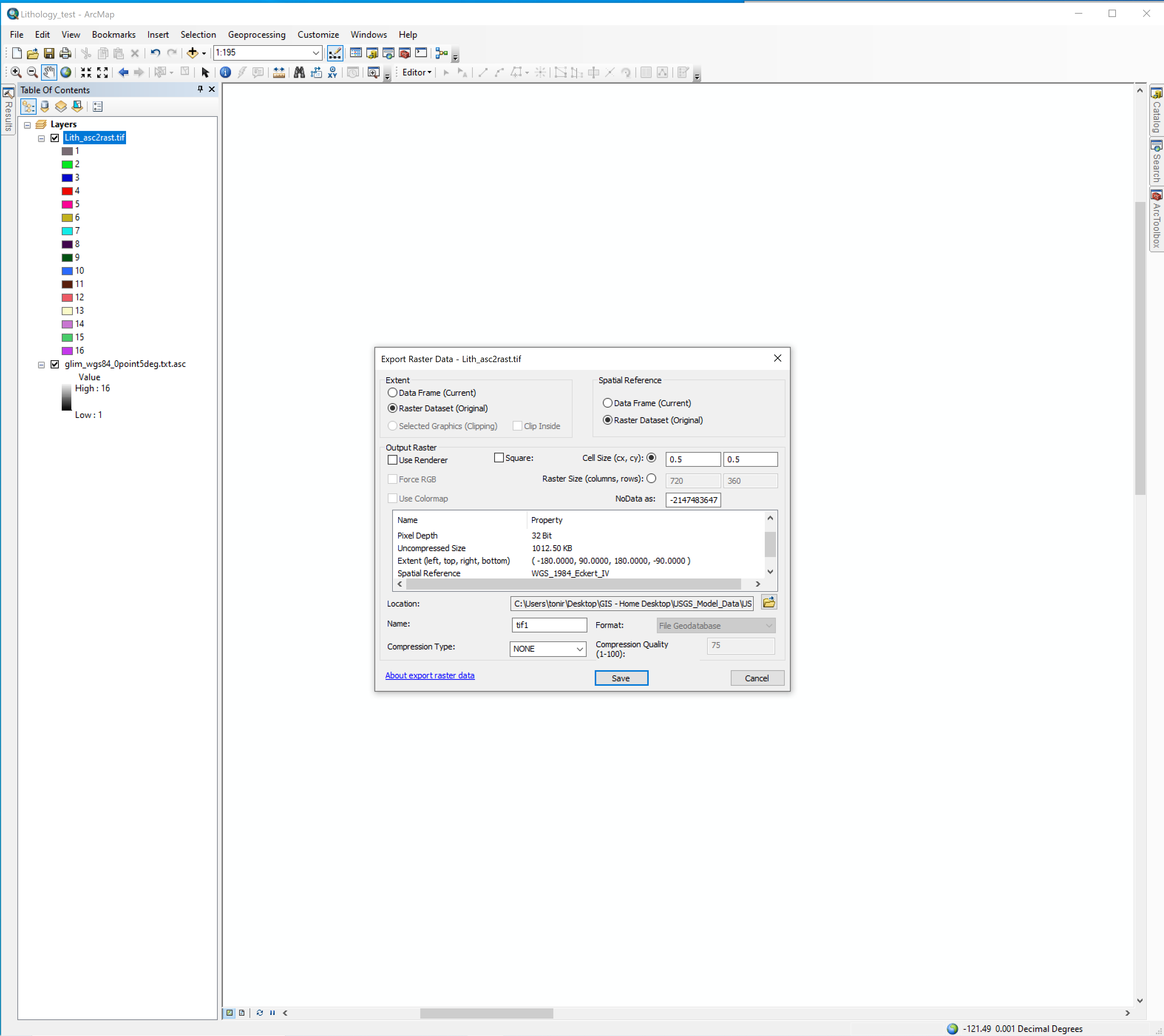
- Mark as New
- Bookmark
- Subscribe
- Mute
- Subscribe to RSS Feed
- Permalink
- Report Inappropriate Content
The original data isn't in Eckert IV, but straight latitude-longitude decimal degrees. Try defining it as the geographic coordinate system 4326 (WGS 1984).
Melita