- Home
- :
- All Communities
- :
- Products
- :
- ArcGIS GeoEvent Server
- :
- ArcGIS GeoEvent Server Questions
- :
- Re: Input Polygon by JSON format
- Subscribe to RSS Feed
- Mark Topic as New
- Mark Topic as Read
- Float this Topic for Current User
- Bookmark
- Subscribe
- Mute
- Printer Friendly Page
- Mark as New
- Bookmark
- Subscribe
- Mute
- Subscribe to RSS Feed
- Permalink
- Report Inappropriate Content
Hi all,
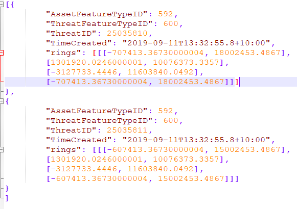
I could generate a point feature in GeoEvent Server 10.7.1 but failed to generate two polygon features by below JSON string.
Could you please point out any possible reason? thanks.
Regards,
Bing
Solved! Go to Solution.
Accepted Solutions
- Mark as New
- Bookmark
- Subscribe
- Mute
- Subscribe to RSS Feed
- Permalink
- Report Inappropriate Content
Hi all
I think I found the format for Geometry, it looks like "Geometry":{rings:[[[XXX, XXX],[XXX, XXX]]]}, I just missed Object for the "rings".
Regards,
Bing
- Mark as New
- Bookmark
- Subscribe
- Mute
- Subscribe to RSS Feed
- Permalink
- Report Inappropriate Content
Hi all
I think I found the format for Geometry, it looks like "Geometry":{rings:[[[XXX, XXX],[XXX, XXX]]]}, I just missed Object for the "rings".
Regards,
Bing
- Mark as New
- Bookmark
- Subscribe
- Mute
- Subscribe to RSS Feed
- Permalink
- Report Inappropriate Content
Hello Bing –
Glad you got what you needed figured out. I noticed, though, that your JSON representation of the polygon geometry has no spatial reference. You will want to include that to "complete" the feature record specification if you want to be able to compare an event record's geometry to, say, a geofence to test spatial coincidence.
You might find the following references helpful:
- Core Concepts - Features and Geometries - Points
- Core Concepts - Features and Geometries - Polylines
- Core Concepts - Features and Geometries - Polygons
Also, GeoEvent Server recently updated its documentation for inbound connectors which includes some relevant illustrations, and there is a blog on using GeoEvent Simulator to pass JSON string representations of geometry which enables you to simulate geometries other than point:
- Input Connectors - Receive Features on a REST Endpoint
- Can I use the GeoEvent Simulator to simulate events with geometries other than Point
Hope these are helpful–
RJ