- Home
- :
- All Communities
- :
- Products
- :
- ArcGIS Pro
- :
- ArcGIS Pro Questions
- :
- Re: How to “clear” the coordinate system of the “M...
- Subscribe to RSS Feed
- Mark Topic as New
- Mark Topic as Read
- Float this Topic for Current User
- Bookmark
- Subscribe
- Mute
- Printer Friendly Page
How to “clear” the coordinate system of the “Map” to get it to “unknown” in ArcGIS Pro,
- Mark as New
- Bookmark
- Subscribe
- Mute
- Subscribe to RSS Feed
- Permalink
- Report Inappropriate Content
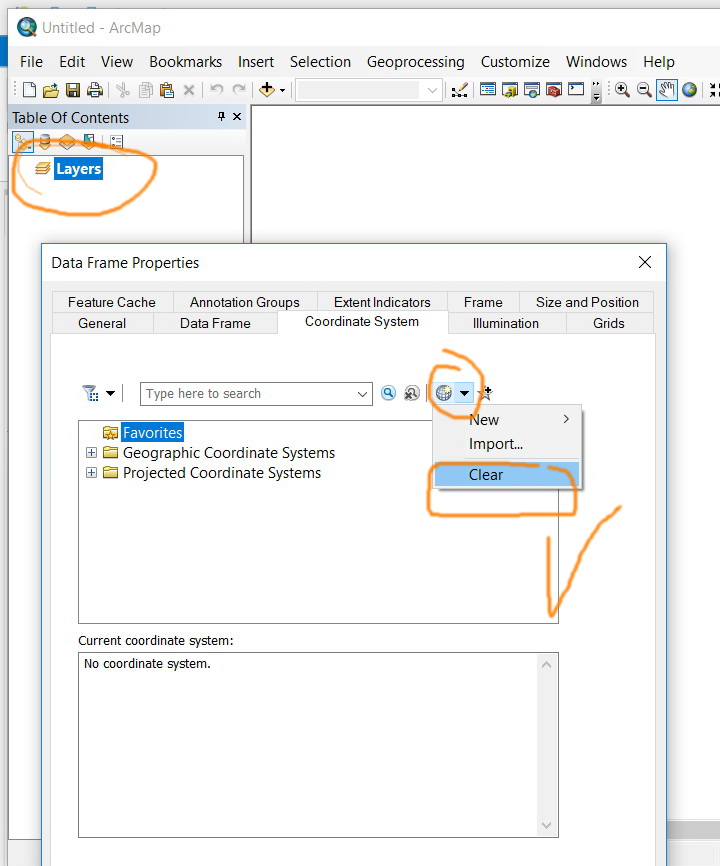
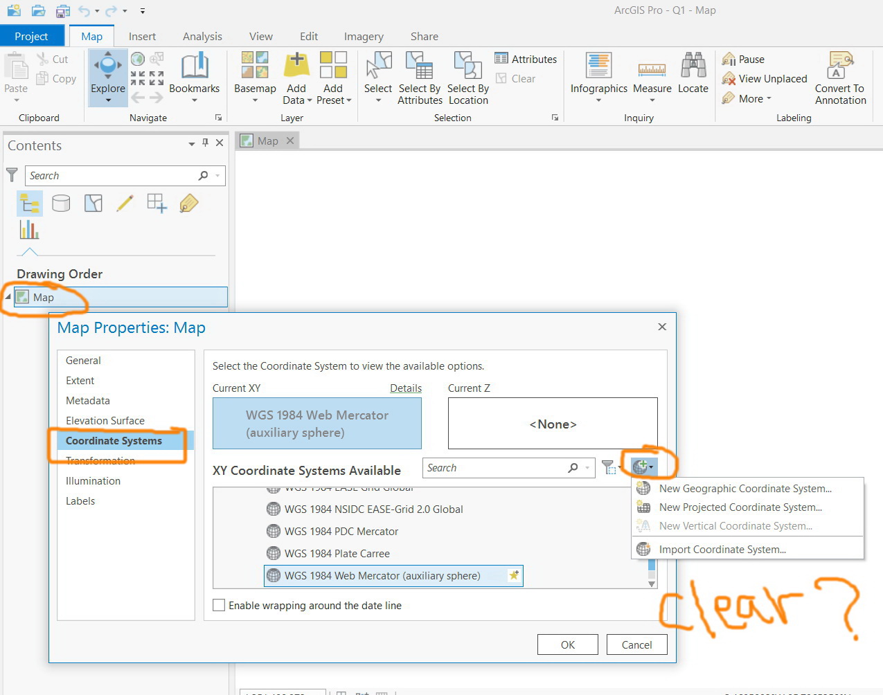
How to “clear” the coordinate system of the “Map” to get it to “unknown” in ArcGIS Pro,
For example, in ArcMap, the clear option is available and one can set the “data frame” to unknown. I couldn’t figure out how to “clear” the coordinate system of the “Map” to get it to “unknown” in ArcGIS Pro as this option is not there
Jamal Numan
Geomolg Geoportal for Spatial Information
Ramallah, West Bank, Palestine
- Mark as New
- Bookmark
- Subscribe
- Mute
- Subscribe to RSS Feed
- Permalink
- Report Inappropriate Content
Nelson - as a Senior Instructor in Esri Training Services, I have zero pull/sway on the AGP development processes and do my best to answer customer questions on the ArcGIS Platform. Esri employees do read/review/provide input on GeoNet threads and do listen to customers requests for equivalency/additional functionalities in software development. The whys and how's of functionality being (or not being added) are beyond my control. Kory Kramer is the ArcGIS Pro Customer Advocacy point of contact and is cc'ed on my response. Perhaps he can provide additional information.
- Mark as New
- Bookmark
- Subscribe
- Mute
- Subscribe to RSS Feed
- Permalink
- Report Inappropriate Content
Understood Robert, and thank you for your input. Coincidence, I attended Grad School with Kory!
Question... what DOES ArcPro do? Project on the fly? Put layers in their respective coordinate systems?
I'm guessing 'Project on the fly' is the only 'OPTION'?
 🙂
🙂
Regards,
Greg
- Mark as New
- Bookmark
- Subscribe
- Mute
- Subscribe to RSS Feed
- Permalink
- Report Inappropriate Content
Love the fly graphic! That's awesome! Small world too about you and Kory - very nice!
So yes, AGP does "project on the fly" as does ArcMap. From the ArcGIS Pro help -
"ArcGIS Pro reprojects data on the fly so any data you add to a map adopts the coordinate system definition of the first layer added. As long as the first layer added has its coordinate system correctly defined, all other data that has correct coordinate system information reprojects on the fly to the coordinate system of the map. This approach facilitates exploring and mapping data, but it should not be used for analysis or editing, because it can lead to inaccuracies from misaligned data between different layers. Data is also slower to draw when it is projected on the fly. If you intend to perform analysis or edit the data, then first project it into a consistent coordinate system and the same coordinate system shared by all your layers. This creates a new version of your data."
- Mark as New
- Bookmark
- Subscribe
- Mute
- Subscribe to RSS Feed
- Permalink
- Report Inappropriate Content
What would be nice.... a banner on the top of the map/data frame which states.
….. CAUTION.... one or more layers is being projected-on-the fly.... CAUTION ….
- Mark as New
- Bookmark
- Subscribe
- Mute
- Subscribe to RSS Feed
- Permalink
- Report Inappropriate Content
Robert LeClair, that is helpful, thank you.
If I may... a follow up question or two and further comment, justification for it to be an option ...(for Kory Kramer as well)
- What happens if the first layer is NOT properly projected, for example, an old piece of Census data has the Coordinate System defined (Define Projection tool) to a Projected Coordinate System instead of Geographic NAD 1983, and the data is then 'Projected' (tool) to a State Plane HARN Projected Coordinate System? The data would be projected on the fly... (looking like it is lined up), the information on it (when properties are viewed) would reference the 'same' coordinate system and projection, but it in fact would be incorrect and would: "it can lead to inaccuracies from misaligned data between different layers. Data is also slower to draw when it is projected on the fly" and "This approach facilitates exploring and mapping data, but it should not be used for analysis or editing"
- I'm seeing the case for a view of the 'data/layers' in their 'own' coordinate system, sans being projected on the fly, because it is a clear (usually) indication that something is amiss, especially when the Projected Coordinate System is saying one thing, but is something quite different. Take the case of the census data in question. In ArcMap, with it being incorrect, it would be off in never never land, and I'd see that, quite clearly. Whereas in AGP, despite my attempts to: "first project it into a consistent coordinate system and the same coordinate system shared by all your layers" it would in fact, by default (without an option to change) be projected on the Fly (unbeknownst to the user).
This is a GREAT discussion by the way, I have learned quite a lot already.
Thank you to everyone who has participated thus far.
- Mark as New
- Bookmark
- Subscribe
- Mute
- Subscribe to RSS Feed
- Permalink
- Report Inappropriate Content
Gregory - this IS a great discussion thread certainly! With regard to your follow-up questions, I'd like to bring in Melita Kennedy to the thread as she's a coordinate system guru for Esri projects. Melita - any thoughts to Gregory's follow-up questions?
- Mark as New
- Bookmark
- Subscribe
- Mute
- Subscribe to RSS Feed
- Permalink
- Report Inappropriate Content
Hi everybody,
If a layer doesn't have a defined coordinate system, it's not projected on-the-fly. It can't be. The software doesn't know anything about it--the units, the map projection, etc. It will be displayed as-is, just as it is in ArcMap. You can still investigate the unknown data's coordinates by either zooming to it and looking at the status bar or opening its properties and looking at its extent.
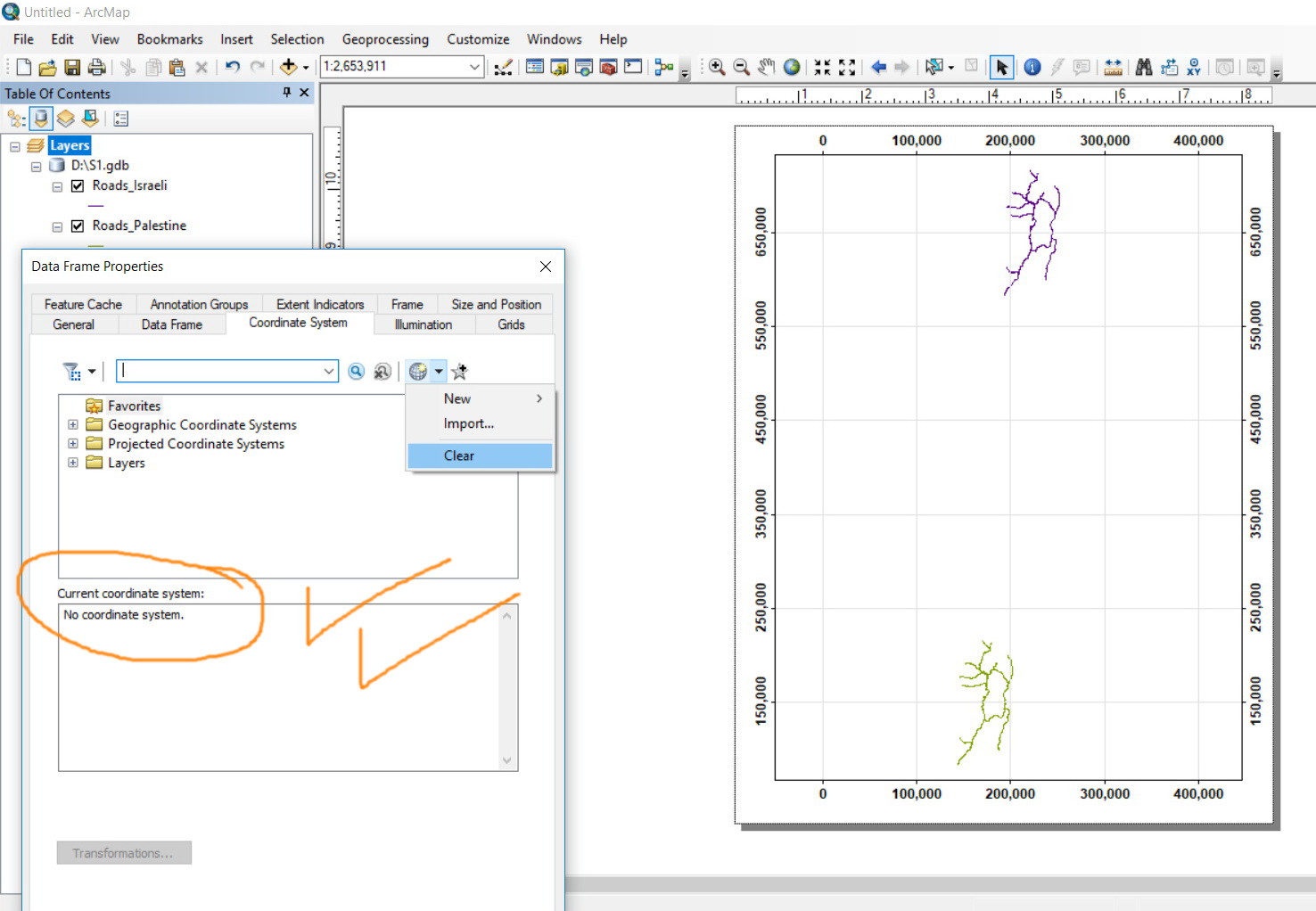
To match the "clear" option in ArcMap in ArcPro:
1. Add the unknown data to a map
2. Add reference data that you want to compare it to. This can be a base map.
3. Make sure the map's coordinate system is set to the reference data's coordinate system.
4. So the reference data is displayed where it is natively. Nothing is happening to its coordinates or extent.
5. The unknown data is also being displayed natively. Nothing is happening to its coordinates or extent.
Now you can compare the location of the unknown data against the reference data.
We've reviewed the decision to not let ArcGIS Pro have an "unknown" xy coordinate system a few times. We've always made the same decision. There are too many side issues that arise if we don't have a known coordinate system.
Melita
- Mark as New
- Bookmark
- Subscribe
- Mute
- Subscribe to RSS Feed
- Permalink
- Report Inappropriate Content
Thanks Melita.
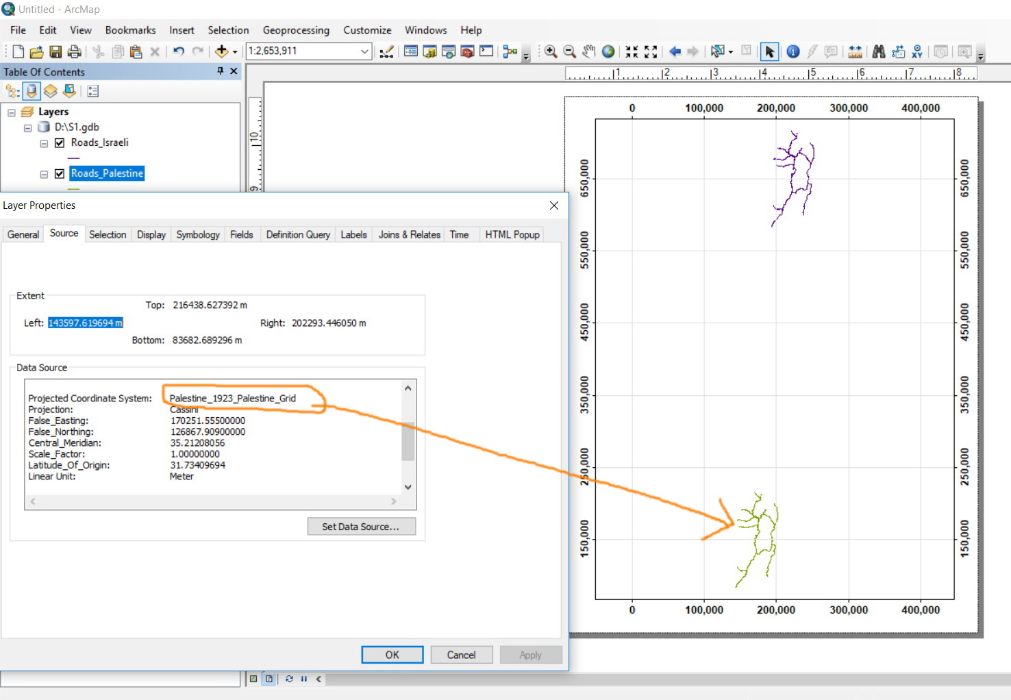
In particular cases, we need to show two layers with respect to each other while they have different coordinate systems. This for sure requires the Map CS (data frame in ArcMap) to be with “unknown” coordinate system.
How such request can be responded in Pro?

Jamal Numan
Geomolg Geoportal for Spatial Information
Ramallah, West Bank, Palestine
- Mark as New
- Bookmark
- Subscribe
- Mute
- Subscribe to RSS Feed
- Permalink
- Report Inappropriate Content
Hi Melita, your suggestion works if the coordinate system is undefined, but what if it is labeled incorrectly? All you have left us with is checking the extent against the label which only works in obvious cases like decimal degree data labeled as UTM. I wonder what Margaret Maher thinks as I know she uses this functionality in her great 'cookbooks' to solve problems in her (excellent) Esri press book Lining Up Data.
- Mark as New
- Bookmark
- Subscribe
- Mute
- Subscribe to RSS Feed
- Permalink
- Report Inappropriate Content
Hi Curtis,
How is this any different than working with it in ArcMap? Yes, you can set the data frame to be "unknown" and see the bad data offset because it's not being projected-on-the-fly. Whether it's getting projected on-the-fly or not, the data must be offset or you wouldn't realize that there's something wrong with it.
In Pro, the data's still offset. You still need reference data that has the correct coordinate system that you can use to compare against the questionable data. Switch the map between the reference data's coordinate system and the bad data's coordinate system. That will tell you the offset. Bad data is 3x too big or small, there's a unit issue. Data is directly north-south--possibly an ellipsoid/sphere (like Web Mercator versus World Mercator).
Melita