- Home
- :
- All Communities
- :
- Products
- :
- Mapping
- :
- Mapping Questions
- :
- Re: Converting hatches to graphics?
- Subscribe to RSS Feed
- Mark Topic as New
- Mark Topic as Read
- Float this Topic for Current User
- Bookmark
- Subscribe
- Mute
- Printer Friendly Page
Converting hatches to graphics?
- Mark as New
- Bookmark
- Subscribe
- Mute
- Subscribe to RSS Feed
- Permalink
- Report Inappropriate Content
I am displaying station numbers with hatches along a pipeline route. Unfortunately they don't show up well when I PDF the maps (for example 25+50 would only show up as 25+). So I'm trying to convert hatch labels to annotation/graphics, but I am not seeing "convert hatches to graphic" tool in my command box under Linear Referencing. Do I need an extension to use this tool?
- Mark as New
- Bookmark
- Subscribe
- Mute
- Subscribe to RSS Feed
- Permalink
- Report Inappropriate Content
This is another critical tool that does not appear to be supported in Pro yet. ESRI wants us to consider Pro a finished and polished product (i.e. not beta) stop removing critical features.
- Mark as New
- Bookmark
- Subscribe
- Mute
- Subscribe to RSS Feed
- Permalink
- Report Inappropriate Content
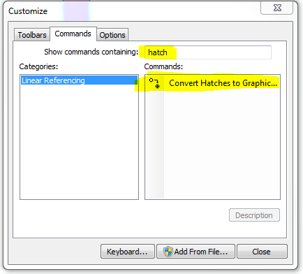
Within ArcGIS Desktop -> Click on "Custommize" text menu, then click on "toolbars", then click on "customize" option at the bottom of the list, then click on "commands" tab, then type in "hatch", click the tool and drag it into an existing toolbar.
Then you will have to first setup an annotation layer through the data frame properties Annotation groups, then you will start editing on the hatched layer, then click on the tool and it will allow you to convert the hatches into graphics, and then use the convert graphics to features from right clicking on the data frame to convert them into a feature class.
The only issue is that this graphic does not contain the information of the stationing. However, you could probably convert hatched line to a point using the feature vertices to point tool while using end or start of the line option; I am unsure how you have the hatching setup, or possibly using a Route event theme based on the information you want and the Spatial Join tool to get the label information into the hatch.
You will have to play around and figure out what works best and then develop a routine that will give you the consistent results that you are looking for.
Good Luck,
Mike
- Mark as New
- Bookmark
- Subscribe
- Mute
- Subscribe to RSS Feed
- Permalink
- Report Inappropriate Content
Please find the community link below that has been posted and the aforementioned functionality is currently in product plan :
https://community.esri.com/ideas/10410-graphics-and-free-text-in-arcgis-pro-maps
Hope this helps!