- Home
- :
- All Communities
- :
- Products
- :
- Mapping and Charting Solutions
- :
- Mapping and Charting Questions
- :
- Re: converting contour lines to DEM
- Subscribe to RSS Feed
- Mark Topic as New
- Mark Topic as Read
- Float this Topic for Current User
- Bookmark
- Subscribe
- Mute
- Printer Friendly Page
- Mark as New
- Bookmark
- Subscribe
- Mute
- Subscribe to RSS Feed
- Permalink
- Report Inappropriate Content
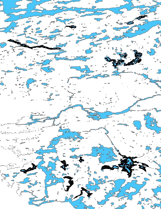
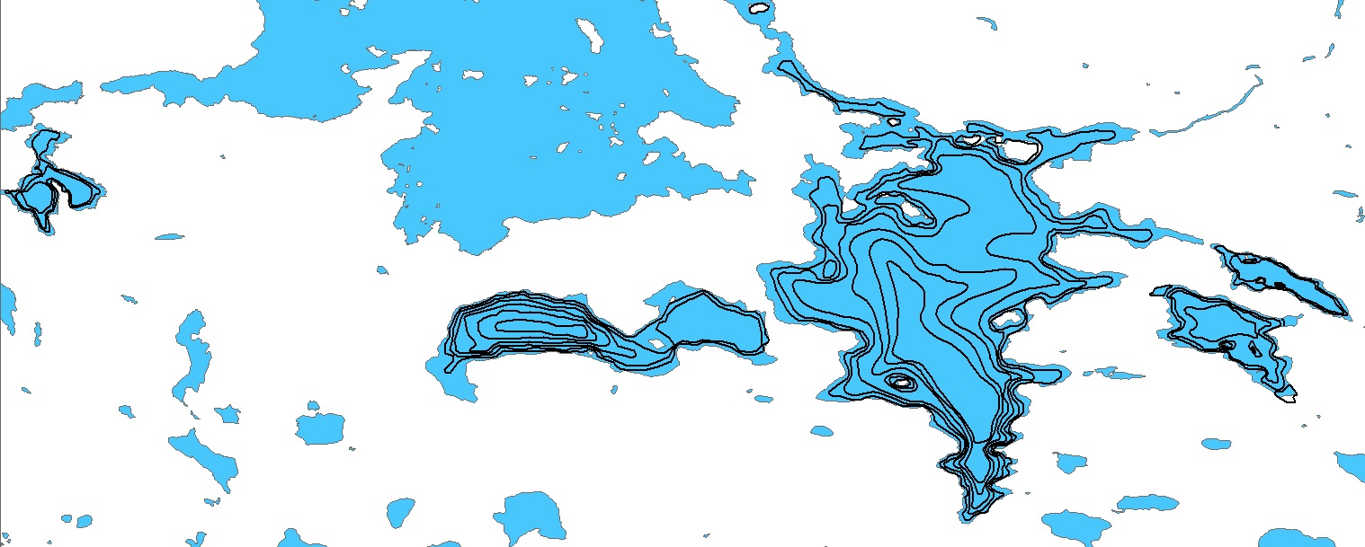
I am using ArcMap Desktop. I have a shape file with contour lines for about eight lakes in an area of about 15 square miles.
The picture below is to give an idea of the distance between lakes and the picture at the bottom is a more zoomed in view of some of the lakes. I already have DEM data for the white area in the pictures. I would like to use the contours lines in the lakes to make DEM data which I could then adjust to make the shallower water light blue and the deeper lake depths a darker blue.
I tried using the TopoToRaster tool but it thinks the area between the lakes is part of the lakes and make dem data for the entire area. Can the TopoToRaster tool do only the lakes with the contour lines? How? Or, is there there a better tool for this?
Solved! Go to Solution.
- Mark as New
- Bookmark
- Subscribe
- Mute
- Subscribe to RSS Feed
- Permalink
- Report Inappropriate Content
I'm getting the same error message re: the YouTube terminated users. It was working this morning (from this same computer)but I didn't take the time to watch it. I was going to do that later....but I guess not...
- Mark as New
- Bookmark
- Subscribe
- Mute
- Subscribe to RSS Feed
- Permalink
- Report Inappropriate Content
I'm pretty sure that the first thing shown in the video was to use the tool: ArcToolbox > 3D Analyst Tools > TIN Management Toolset > Create TIN
I get a failure error every time. I am using a vector shape file with contour lines as the input. If I add the contours shape file and don't type anything in the features box, I get an error message the No Features were selected. If I add the contour shape file and then type "DEPTH" in the features box, (DEPTH is the name of one of the columns in the Attributions Table) then I get a general, non-specific 9999 (or whatever) error. I tried using various Spatial References and that didn't change anything.
Do I need to do something with the contours shape file, before I use the Create TIN tool? Would it help if made the shape file available?
- Mark as New
- Bookmark
- Subscribe
- Mute
- Subscribe to RSS Feed
- Permalink
- Report Inappropriate Content
Thank you all for helping to solve this problem. Thank you, le duc tri, for the YouTube video, I am glad I was able to watch it before it was deleted. Thanks, Curtis Price, for pointing out that I needed to use a projected coordinate system.
At first I got an error message when I tried to run the Create TIN tool,
1) then I set the layer to the correct Projected Coordinate System but I still got an error message.
2) Then I set the Data Frame to the correct Projected Coordinate System and the Create TIN tool worked, BUT I didn't realize that the "Height Field" was a drop-down list, so --finally--
3) I choose DEPTH from the Height Field drop-down list and then the TIN was created and looks great.
- Mark as New
- Bookmark
- Subscribe
- Mute
- Subscribe to RSS Feed
- Permalink
- Report Inappropriate Content
Since this is related, I am trying to convert points to a smooth DEM. I have the contours lines (derived from kriging of the point data and then used the Contour tool to get the lines), converted them to tin, and made the raster. However, the DEM is extremely pixelated. Is there anyway to smooth this out?
Thank you,
Karl
- Mark as New
- Bookmark
- Subscribe
- Mute
- Subscribe to RSS Feed
- Permalink
- Report Inappropriate Content
Karl
Which kriging method did you use?
Are you using Spatial or Geostatistical Analyst?
Can you provide an image of the contour lines?
Thanks
-Steve
- Mark as New
- Bookmark
- Subscribe
- Mute
- Subscribe to RSS Feed
- Permalink
- Report Inappropriate Content
Steve,
I used Kriging through the spatial analyst toolbar, using the Ordinary Method and spherical semivariogram model. I am working to get an image up. One problem may be that the Coordinate system for the points is in WGS1984 instead of NAD 1983 Zone 18?
- « Previous
- Next »
- « Previous
- Next »