- Home
- :
- All Communities
- :
- Products
- :
- Spatial Data Science
- :
- Spatial Data Science Questions
- :
- Is it possible to build a custom geolocator based ...
- Subscribe to RSS Feed
- Mark Topic as New
- Mark Topic as Read
- Float this Topic for Current User
- Bookmark
- Subscribe
- Mute
- Printer Friendly Page
Is it possible to build a custom geolocator based upon subdivision name and lot number?
- Mark as New
- Bookmark
- Subscribe
- Mute
- Subscribe to RSS Feed
- Permalink
- Report Inappropriate Content
I've been approached by our company's wastewater division to create geocoded data from an Excel spreadsheet. Normally, this would be easy, but the spreadsheet contains a list of subdivision names and lot numbers where step tanks have been installed. There are no addresses, latitude, or longitude information available in the spreadsheet for these tanks. Is there a way to create a custom geolocator based upon subdivision name and lot number? I do have access to our local county's planning department data for subdivision polygons and parcels.
Any thoughts and suggestions are appreciated as I am drawing a blank on how to process this data request.
Bethany G. Hall
Solved! Go to Solution.
Accepted Solutions
- Mark as New
- Bookmark
- Subscribe
- Mute
- Subscribe to RSS Feed
- Permalink
- Report Inappropriate Content
Bethany:
1. Is there any address information associated with the certificate of occupancy that was maintained by the Step Dept?
2. In the parcel data are the lot and subdivision values in separate fields? If so, you could probably get away with creating a locator with the Create Locator tool using the PointAddress role where you map the Lot field to the House Number field from the role and Subdivision field to the Street Name field from the role.

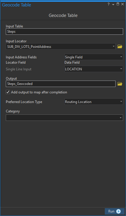
You will need to concatenate the lot number and subdivision fields in the spreadsheet into a single field, then use that field to geocode the spreadsheet with the Geocode Table tool. Right-click the table in the Contents pane and select Geocode Table.
- Mark as New
- Bookmark
- Subscribe
- Mute
- Subscribe to RSS Feed
- Permalink
- Report Inappropriate Content
I have a few questions to help figure out a solution
1. What application and version are you using or have available for this task? ArcMap, ArcGIS Pro
2. Do you have spatial features that represent the step tank? If so, does it include the same step # that is in the spreadsheet? If yes, you could build a locator based on the step # or if you combined the step # and the lot # into a new field and use that to build the locator and search on.
3. Do you need to geocode to the lot level or step tank level?
4. What attributes do the subdivision and parcel features have that would help?
- Mark as New
- Bookmark
- Subscribe
- Mute
- Subscribe to RSS Feed
- Permalink
- Report Inappropriate Content
Hey Shana,
I hope these answers help as I do not currently know how to create points from the spreadsheet as this isn't much information to go on within the spreadsheet. I'm working on creating a service, dashboard, and web app for the step crews to use when adding this tank information once the certificate of occupancy is issued. We need points to get started as we didn't start GPS data collection on step tanks until three years ago with Collector. We currently have 1,500 tanks GPS'ed but this list of tanks has over 6,000 from when our company began installing tanks in the late 1990s and early 2000s.
1. What application and version are you using or have available for this task? ArcMap, ArcGIS Pro - W have access to both software platforms and I prefer to use ArcGIS Pro.
2. Do you have spatial features that represent the step tank? No, as this data is different from our current step tank feature class. If so, does it include the same step # that is in the spreadsheet? No, it seems our Step Department was keeping separate records for all certificate of occupancy once the that was approved by building and codes inspectors.
3. Do you need to geocode to the lot level or step tank level? We were thinking goe-coding to the lot level to at least get a point created for these tanks
4. What attributes do the subdivision and parcel features have that would help? We receive data from our local county's GIS department. The parcel data has subdivision and lot number attributes while the subdivision polygons only contain the subdivision boundary and general information about the development. I trust the parcel data to be authoritative.
- Mark as New
- Bookmark
- Subscribe
- Mute
- Subscribe to RSS Feed
- Permalink
- Report Inappropriate Content
Bethany:
1. Is there any address information associated with the certificate of occupancy that was maintained by the Step Dept?
2. In the parcel data are the lot and subdivision values in separate fields? If so, you could probably get away with creating a locator with the Create Locator tool using the PointAddress role where you map the Lot field to the House Number field from the role and Subdivision field to the Street Name field from the role.
You will need to concatenate the lot number and subdivision fields in the spreadsheet into a single field, then use that field to geocode the spreadsheet with the Geocode Table tool. Right-click the table in the Contents pane and select Geocode Table.
- Mark as New
- Bookmark
- Subscribe
- Mute
- Subscribe to RSS Feed
- Permalink
- Report Inappropriate Content
Since this question was originally posted the Parcel role was added to ArcGIS Pro, which you could try using this role to build the locator with the parcel data. https://pro.arcgis.com/en/pro-app/latest/help/data/geocoding/introduction-to-locator-roles.htm#ESRI_...