- Home
- :
- All Communities
- :
- Industries
- :
- Transportation
- :
- Public Transit
- :
- Public Transit Questions
- :
- Re: How to snap multimodal stops/points precisely/...
- Subscribe to RSS Feed
- Mark Topic as New
- Mark Topic as Read
- Float this Topic for Current User
- Bookmark
- Subscribe
- Mute
- Printer Friendly Page
How to snap multimodal stops/points precisely/exactly!!! to transportation lines?
- Mark as New
- Bookmark
- Subscribe
- Mute
- Subscribe to RSS Feed
- Permalink
- Report Inappropriate Content
Hi,
I have a problem that I can not solve. I have pretty much experience with ArcGIS, especially with transportation analysis.
I have one layer of multimodal stops, where is possible to change transportation mode, i.e. between bus and metro. In network dataset such stops represent connection points between bus and metro. Therefore such stops must be assigned to both connectivity groups - bus and metro.
One important condition is that these points must be located exactly on the line of transportation network. I tried to do it by geoprocessing tool Snap. It looked good, but when I zoomed in, I found out that the points do not lie exactly on the line. I tried many other tricks, but no success.
Then I used tool Locate Features Along Route. The result was a table, which I used to perform a Display Route Events. The result was a point layer Route Events. Only in this layer all points (multimodal stops) were located exactly on the transport lines, even when I zoomed in to maximum. But..... I can not use the point-layer Point Events as an input layer for network dataset. I must change it to shapefile or feature class. But then - points move a little bit away from transport lines.
I am in a kind of trap and I can not go on with my work.
Thank you very much for your help!
Klemen
Solved! Go to Solution.
- Mark as New
- Bookmark
- Subscribe
- Mute
- Subscribe to RSS Feed
- Permalink
- Report Inappropriate Content
I now see that your input coordinate system is "WGS 84" (World Geodetic System 1984) - Esri probably does not have this coordinate system in projection engine library. Most probably it's a custom coordinate system? Is this coordinate system registered with EPSG?
- Mark as New
- Bookmark
- Subscribe
- Mute
- Subscribe to RSS Feed
- Permalink
- Report Inappropriate Content
Yes, EPSG is 4326.
- Mark as New
- Bookmark
- Subscribe
- Mute
- Subscribe to RSS Feed
- Permalink
- Report Inappropriate Content
Klemen Prah, I see @Neil Ayres has already figured it out. Your spatial reference properties are slightly (or may be more than slightly) different than the WGS 1984.If you export your spatial reference to a string you'll see that the circleed part is different:
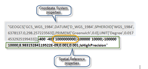
In the installed WGS 1984 this value is: -400 -400 11258999068426.2
In your WGS 1985 this value is: -400 -400 1111947193.4591;
I don't know whether this different is causing the error. You can Project your data to WGS 1984 using the Project tool (Data Management Tools toolbox) and then try again.
- « Previous
-
- 1
- 2
- Next »
- « Previous
-
- 1
- 2
- Next »