- Home
- :
- All Communities
- :
- User Groups
- :
- CAD/GIS Data Integration
- :
- Questions
- :
- Re: Comparing Two World Files for Changes in Geore...
- Subscribe to RSS Feed
- Mark Topic as New
- Mark Topic as Read
- Float this Topic for Current User
- Bookmark
- Subscribe
- Mute
- Printer Friendly Page
Comparing Two World Files for Changes in Georeferencing
- Mark as New
- Bookmark
- Subscribe
- Mute
- Subscribe to RSS Feed
- Permalink
- Report Inappropriate Content
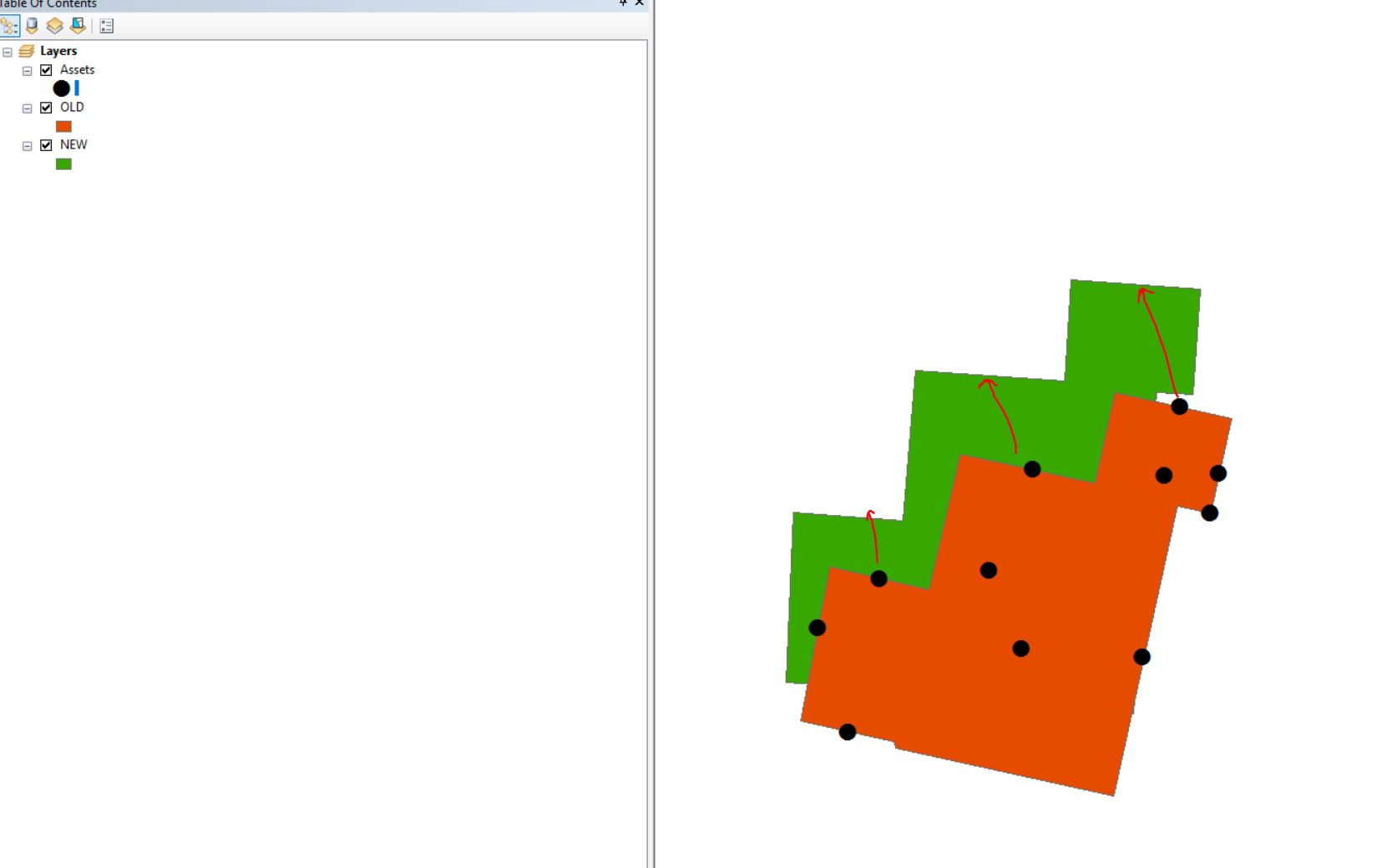
I have been georeferencing CAD drawings and generating world files of buildings for accurately locating floor plans based on their location in an aerial image. These floor plans are managed in CAD. I have a current world file and an outdated world file. I need to compare the two CAD drawings either in CAD, in GIS, or via the world file information to communicate how much the building has shifted, in what direction, and/or how much rotation has occurred so that interior assets can be moved accordingly. Is there any way to gather this information without manually measuring each movement as the file is georeferenced?
- Mark as New
- Bookmark
- Subscribe
- Mute
- Subscribe to RSS Feed
- Permalink
- Report Inappropriate Content
The world file does not record the extent, it records the xy to real world transformation. The world file itself has the parameters in it that records the shift and rotation, if you need to quantify this use could calculate them from the parameters.
I'm wondering if you want to compare the extent of the two datasets instead. The extent is reported in the properties of the dataset or its layer (in ArcMap). In code you can print it out (say in a model within the Calculate Value tool) with the arcpy python expression
str(arcpy.Describe(dataset).extent)- Mark as New
- Bookmark
- Subscribe
- Mute
- Subscribe to RSS Feed
- Permalink
- Report Inappropriate Content
I don't think I described it quite well. I am adjusting or georeferencing CAD floor plan drawings to aerial imagery, saving a world file of the updated location, and then converting the data to GIS using FME. I then need to convey both the distance the floor plans were moved AND the rotation as some were not aligned properly. This way all the associated building assets can be moved accordingly.
- Mark as New
- Bookmark
- Subscribe
- Mute
- Subscribe to RSS Feed
- Permalink
- Report Inappropriate Content
World files for CAD datasets—Help | ArcGIS Desktop
The above reference describes CAD world files. Isn't the shift just given by the difference (x2-x1, y2-y1) of the first coordinate pair?
I guess I still don't understand as the world file should apply to the entire drawing, not just the edges.
- Mark as New
- Bookmark
- Subscribe
- Mute
- Subscribe to RSS Feed
- Permalink
- Report Inappropriate Content
This may not be a CAD or world file related question. The world files were created to correctly reference in building floor plans that were incorrectly located. The real question is how to tell editors the distance and rotation floorplans have moved so they can move their assets to the new corrected location without manually moving every point. If they know the angle the building moved and the rotation they can quickly apply that to all points.