- Home
- :
- All Communities
- :
- Products
- :
- Data Management
- :
- Data Management Questions
- :
- Re: Changing coordinates of geottaged photos
- Subscribe to RSS Feed
- Mark Topic as New
- Mark Topic as Read
- Float this Topic for Current User
- Bookmark
- Subscribe
- Mute
- Printer Friendly Page
Changing coordinates of geottaged photos
- Mark as New
- Bookmark
- Subscribe
- Mute
- Subscribe to RSS Feed
- Permalink
- Report Inappropriate Content
So here is an example. - I've geottaged photos, which was converted into points. But iam not happy about where those points are placed by (not very acuarate gps). But in map, i know for sure, where that point should be. I know - i can manually move points, but gps place in photos wont change if i'll remove and add them again. So my question is - is there any tool or command to move geottaged photo and change gps place in photo's with it.
- Mark as New
- Bookmark
- Subscribe
- Mute
- Subscribe to RSS Feed
- Permalink
- Report Inappropriate Content
You will need to edit the EXIF data on each photo to reflect the correct GPS coordinates. A quick Google search shows this bit of freeware, but I'm sure you could find others.
For a more programmatic approach I'd try this -
- Run Photos to Points as you have
- Move the points to the correct locations.
- Use Python to update the X,Y in the photo EXIF data; here is a good blog post on reading EXIF using Python. And here is a link to Piexif - "To simplify exif manipulations with Python. Writing, reading, and more… Piexif is pure Python. To everywhere with Python."
Hope this is helpful.
- Mark as New
- Bookmark
- Subscribe
- Mute
- Subscribe to RSS Feed
- Permalink
- Report Inappropriate Content
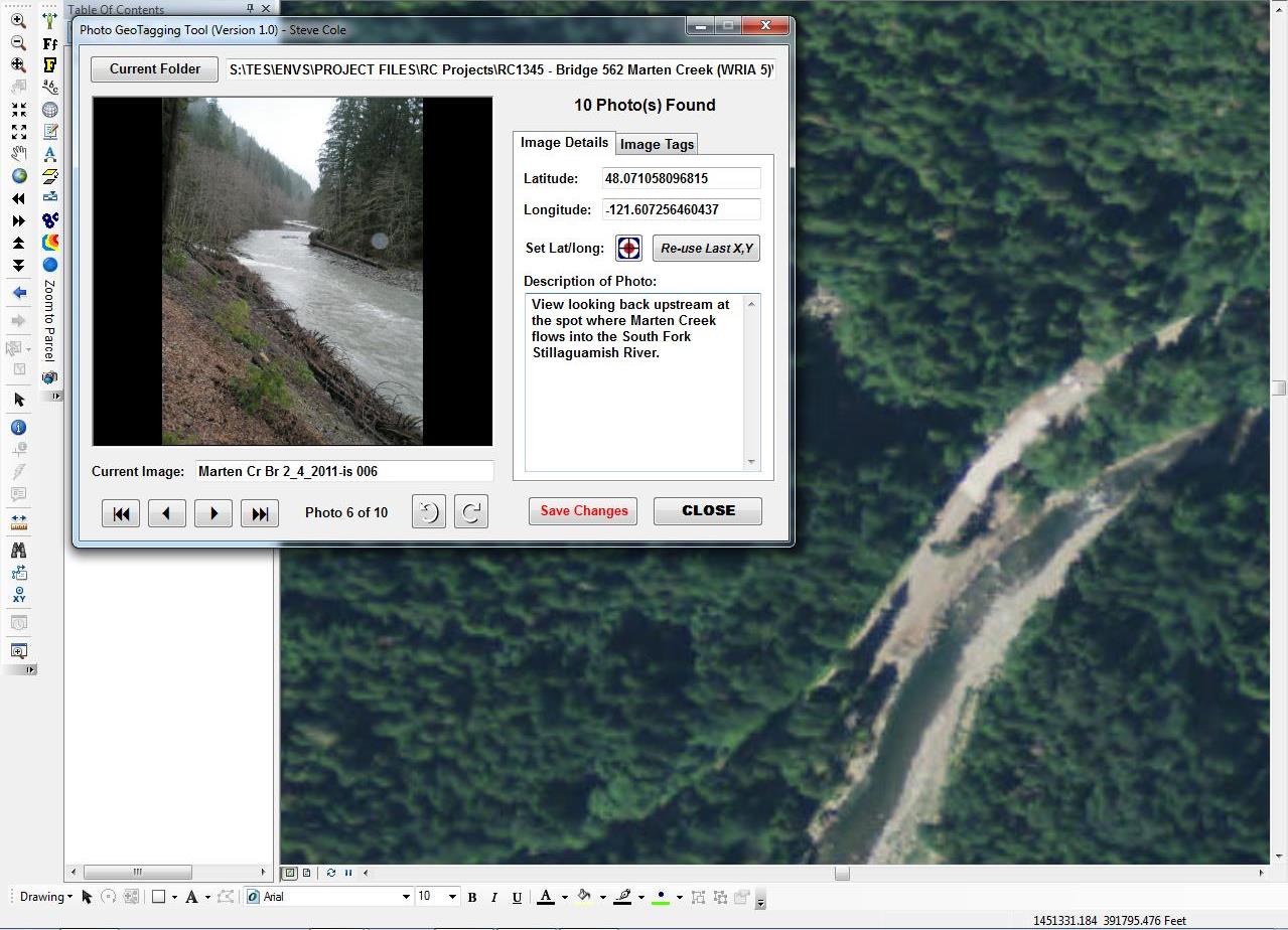
As Josh eludes, you have to work with the EXIF information to adjust the embedded lat/long information. I spent some time exploring this years ago and worked on a .NET add-in for Arcmap to add geotag coordinates to photos that didn't have any. I'm attaching the VB.NET code project information if you're so inclined to pursue it. The add-in loads in 10.5.1 with some errors and I don't have the time to debug them, unfortunately. A few errors are due to network file locations that have changed since I developed this originally and there's some issue related to Outlook (my code tries to extract user information from Outlook and add that to some of the EXIF fields). Anyways, it may not be a big deal to fix but I don't have the time.
Anyways, To use my add-in-
1. Install the add-in
2. Add the "Geotag Photos" button to your Arcmap dialog (Customize->Commands->Add-in Tools->Geotag Photos)
3. Zoom into an area where your photos were taken.
4. Click the Geotag Photos button to launch the interface.
5. Click the current folder button to navigate to the folder containing your photos that you need to adjust the geotag coordinates.
6. Use the image browse tools at the bottom (the record navigation buttons) to find the photo you want to modify. Once the photo loads, it's lat/long coordinates should be displayed at right.
7. To update the lat/long coordinates, click the crosshair tool and then click its proper location in the Data Frame. Click the Save Changes button.
That's probably what you were looking to do. Sorry it's not a working solution, as provided.
Screenshot: