- Home
- :
- All Communities
- :
- Products
- :
- ArcGIS Pro
- :
- ArcGIS Pro Questions
- :
- Overlapping 2 rasters using ARCGIS
- Subscribe to RSS Feed
- Mark Topic as New
- Mark Topic as Read
- Float this Topic for Current User
- Bookmark
- Subscribe
- Mute
- Printer Friendly Page
Overlapping 2 rasters using ARCGIS
- Mark as New
- Bookmark
- Subscribe
- Mute
- Subscribe to RSS Feed
- Permalink
- Report Inappropriate Content
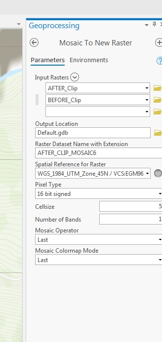
I am trying to overlap 2 rasters (same region, but acquired in different dates). My objective is to know how much the soil changed after a landslide. I am using "Mosaic to Raster" to set Raster "AFTER_Clip" in the same spatial reference as Raster "BEFORE_Clip". The rasters have the following information.
BEFORE_Clip (before the landslide)
elevation info: EGM96
pixel size: 5m
data type: signed 16-bit
AFTER_Clip (after the landslide)
elevation info: WGS84
pixel size: 2m
data type: Float (32 bit)
I am probably doing something wrong because I am not getting satisfactory results.
If anyone can point me where I am wrong, or another better tool to use in this case I would appreciate it very much.
Update: when I choose the tool "Project Raster" the option "vertical" is not active. That means the rasters (DSM) do not have vertical coordinate system?
- Mark as New
- Bookmark
- Subscribe
- Mute
- Subscribe to RSS Feed
- Permalink
- Report Inappropriate Content
Hello Alessandra,
You may find this link helpful for defining the coordinate system of the "After_Clip" raster. You should be able to Import the coordinate system information from the Before_Clip raster to ensure that they are the same:
Specify a coordinate system—Properties of maps | ArcGIS Desktop
To answer your second question about the Project Raster tool, the Vertical parameter is unavailable and is only available when the input and output coordinate systems have a vertical coordinate system (VCS), and the input feature class coordinates have z-values. See the last bullet point under the "Usage" section at this link: