- Home
- :
- Community Resources
- :
- Member Introductions
- :
- Re: Introduce Yourself!
- Subscribe to RSS Feed
- Mark Topic as New
- Mark Topic as Read
- Float this Topic for Current User
- Bookmark
- Subscribe
- Mute
- Printer Friendly Page
Introduce Yourself!
- Mark as New
- Bookmark
- Subscribe
- Mute
- Subscribe to RSS Feed
- Permalink
- Report Inappropriate Content

Welcome to GeoNet!
We are a community that collaborates, learns and shares together. To help you connect with other members, we started this introduction thread. Think of this as your intro to GeoNet networking and a chance to get to know each other as we begin our GeoNet journey.
Please introduce yourself to the rest of the community by sharing your answers to the questions in the comments section below.
- Where do you work and what is your role?
- What GIS success have you had this year and what product did you use? (big or small - no win is out of bounds)
- What is your expertise (GIS related or not), and how can that help the community?
Bonus Round! Post the coordinates to your favorite place on earth.
note: this post has been archived, and is available in read only mode. To create a new introduction, please visit the new GeoNet Member Introductions space. Thank you!
Manager, Community Experience & Programs
- Mark as New
- Bookmark
- Subscribe
- Mute
- Subscribe to RSS Feed
- Permalink
- Report Inappropriate Content
Great photos! Kea and Kaka are basically feathered monkeys.
- Mark as New
- Bookmark
- Subscribe
- Mute
- Subscribe to RSS Feed
- Permalink
- Report Inappropriate Content
- Where do you work and what is your role?
I work for large multi-national engineering professional services firm WSP where I manage the geospatial team for several states in Australia, based in Melbourne.
- What GIS success have you had this year and what product did you use? (big or small - no win is out of bounds)
2019 is still young but... replacing a >200-page asset condition report with a simple but dynamic operations dashboard.
- What is your expertise (GIS related or not), and how can that help the community?
I have been in GIS for 25 years and have been lucky to work across many industries and applications of GIS. I'm also a good cook!
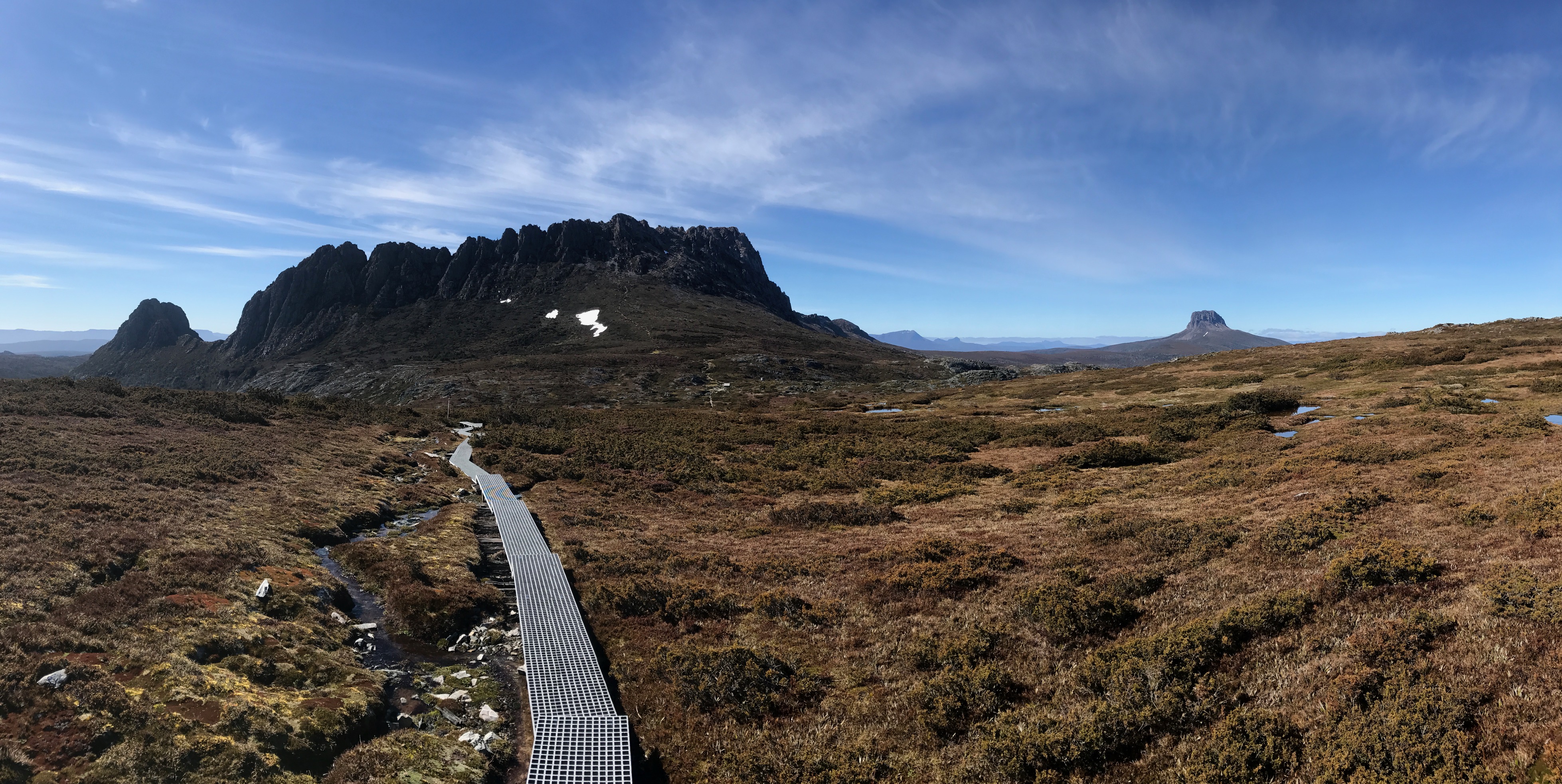
Post the coordinates to your favorite place on earth
-41.671073°, 145.943356° - Cradle Mountain National Park, Tasmania
Here's a photo from October 2018 to whet your appetite...
- Mark as New
- Bookmark
- Subscribe
- Mute
- Subscribe to RSS Feed
- Permalink
- Report Inappropriate Content
That's a great photo Peter!
- Mark as New
- Bookmark
- Subscribe
- Mute
- Subscribe to RSS Feed
- Permalink
- Report Inappropriate Content
Holy Cow! What a capture!
- Mark as New
- Bookmark
- Subscribe
- Mute
- Subscribe to RSS Feed
- Permalink
- Report Inappropriate Content
Hi Peter, Welcome to GeoNet! Sounds like you have your work cut out for you in 2019, hopefully, you can find some helpful info here: Operations Dashboard for ArcGIS. This is a great place to ask questions as you progress with your project.
Also sounds like you have a wealth of GIS experience to share with the community, we welcome your experiences and expertise!
Beautiful location!!
Cheers!
Manager, Community Experience & Programs
- Mark as New
- Bookmark
- Subscribe
- Mute
- Subscribe to RSS Feed
- Permalink
- Report Inappropriate Content
That's a really beautiful picture, Peter.
- Mark as New
- Bookmark
- Subscribe
- Mute
- Subscribe to RSS Feed
- Permalink
- Report Inappropriate Content
- Mark as New
- Bookmark
- Subscribe
- Mute
- Subscribe to RSS Feed
- Permalink
- Report Inappropriate Content
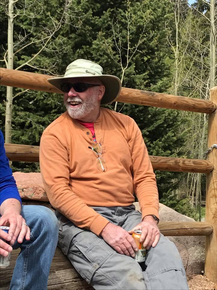
- Where do you work and what is your role?
I am the GIS coordinator (full-time volunteer [retired GIS coordinator for a small City in AZ]) for the Trail and Open Space Coalition in Colorado Springs.
- What GIS success have you had this year and what product did you use? (big or small - no win is out of bounds)
I have been working on a joint effort with the Rocky Mountain Field Institute and the Pike National Forest to develop a trail development and management plan for the Waldo Canyon burn area near Garden of the Gods Park.
- What is your expertise (GIS related or not), and how can that help the community?
I have been using GIS in major planning programs for over 25 years primarily in the fields of wildlife management, water resources, environmental planning and community engagement. I am currently working on a number of "story maps" to illustrate community programs. I am an avid mountain biker and work with the local mountain bike advocacy group Medicine Wheel Trail Advocates on trail planning and sustainable trail construction.
Garden of the Gods 38.8784° N, 104.8698° W
- Mark as New
- Bookmark
- Subscribe
- Mute
- Subscribe to RSS Feed
- Permalink
- Report Inappropriate Content
Hi Michael,
Welcome to GeoNet, love the candid pic, you look super relaxed and enjoying life! But why wouldn't you, working in Colorado surrounded by so much beautiful nature! Looks like you have some great experiences and projects, thanks for sharing. If you haven't come across these sites yet, they may be of interest:
State and Local - Environment and Natural Resources
Cheers!
Manager, Community Experience & Programs
- Mark as New
- Bookmark
- Subscribe
- Mute
- Subscribe to RSS Feed
- Permalink
- Report Inappropriate Content
Where do you work and what is your role?
My name is Ned Troshanov and I work as an Aquifer Data Analyst for the Edwards Aquifer Authority, San Antonio, Texas.
What GIS success have you had this year and what product did you use?
I succeeded to create a 3D geostructural model of the San Antonio segment of the Edwards Aquifer (Balcones Fault Zone) based on spatial interpolation of well geophysical log data in form of raster datasets of the available lithological formation in ArcMap and subsequent extruding of the spaces between their TIN raster datasets in ArcScene.
What is your expertise (GIS related or not), and how can that help the community?
As a geologist and hydrogeologist, I'm using ArcGIS for interpolation of point data of different variable (geological units elevations, groundwater elevation surfaces, water-quality data, etc.) to visualize their space distribution in the subsurface and identify zones of functional interruptions (indicating inferred fault zones).