- Home
- :
- All Communities
- :
- Products
- :
- ArcGIS Earth
- :
- ArcGIS Earth Questions
- :
- Re: ArcGis 1.8
- Subscribe to RSS Feed
- Mark Topic as New
- Mark Topic as Read
- Float this Topic for Current User
- Bookmark
- Subscribe
- Mute
- Printer Friendly Page
ArcGis 1.8
- Mark as New
- Bookmark
- Subscribe
- Mute
- Subscribe to RSS Feed
- Permalink
- Report Inappropriate Content
Is ArcGis Earth 1.8 still free? I'm not logged in and none of the base maps are available. Do you have to be logged in to access the maps? Does being logged in imply you need a paid account?
- Mark as New
- Bookmark
- Subscribe
- Mute
- Subscribe to RSS Feed
- Permalink
- Report Inappropriate Content
main help
and from here
Guided tour—ArcGIS Earth | ArcGIS
Signing in to ArcGIS Online or ArcGIS Enterprise allows you to access your content, group content, your organization's content, basemap and terrain, and geocoding service settings of your organization for use in ArcGIS Earth.
for other scenarios you may have to explore further
- Mark as New
- Bookmark
- Subscribe
- Mute
- Subscribe to RSS Feed
- Permalink
- Report Inappropriate Content
To follow-up on Dan's comment, since you asked about "paid account, you can get a free public account. From FAQ—ArcGIS Online Help | ArcGIS
Can I use ArcGIS Online free?
Yes, if it is for noncommercial use. With a free public account, you can create, store, and manage maps, scenes, layers, and apps, and share them with others. You also get access to content shared by Esri and GIS users around the world.
- Mark as New
- Bookmark
- Subscribe
- Mute
- Subscribe to RSS Feed
- Permalink
- Report Inappropriate Content
Ok, but even after I login all the base maps have a yellow triangle and cannot be selected (which is the same if I don't login). And the initial globe image is very blocky...that's the UK in the image below! Google earth is SO much better resolution! What's going on?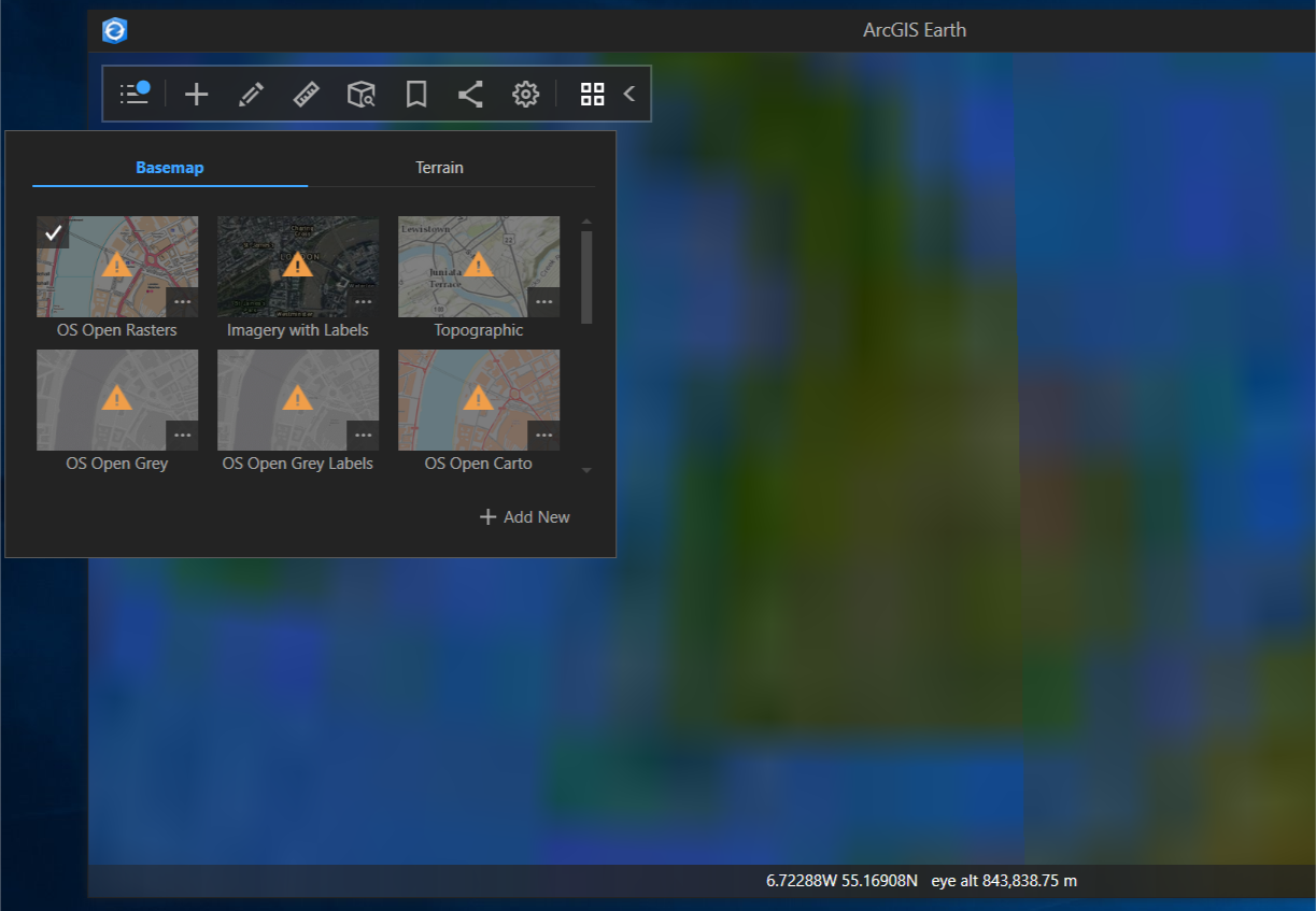
- Mark as New
- Bookmark
- Subscribe
- Mute
- Subscribe to RSS Feed
- Permalink
- Report Inappropriate Content
Hi Andrew
Without signing in, I have access to the all the basemaps and even others if I click on the + Add New button. I was only prompted to sign in when I tried to add the Sentinel 2 views image service (which is only available to those to have a Organizational account).

For me the resolution is as great as it is with ArcGIS Pro or any other of the Esri products consuming the imagery service in a 3D view.
I suspect there is a problem with your installation.
- Mark as New
- Bookmark
- Subscribe
- Mute
- Subscribe to RSS Feed
- Permalink
- Report Inappropriate Content
I also suspected a problem with the upgrade to V1.8. I've uninstalled and reinstalled but it's still the same. Any other ideas what I can try?
- Mark as New
- Bookmark
- Subscribe
- Mute
- Subscribe to RSS Feed
- Permalink
- Report Inappropriate Content
Hi Andrew,
From the screenshot, I think you have set the spatial reference of Earth as WGS84? Please try to go Settings > General > Spatial Reference to select Web Mercator and restart Earth to have a look.
Most of the online basemaps are ArcGIS Rest Services, you can get the spatial reference from the Spatial Reference parameter of the service. For World_Imagery (MapServer), its spatial reference is Web Mercator(102100/3857). Please make sure the spatial reference of Earth meets to the spatial reference of services, so that you can have the data rendered well.
Thanks,
Xuewen
- Mark as New
- Bookmark
- Subscribe
- Mute
- Subscribe to RSS Feed
- Permalink
- Report Inappropriate Content
Thx to Xuewen, you were right, that fixed my problem