- Home
- :
- All Communities
- :
- Products
- :
- Spatial Statistics
- :
- Spatial Statistics Questions
- :
- Re: raster to polygon, still looks like raster
- Subscribe to RSS Feed
- Mark Topic as New
- Mark Topic as Read
- Float this Topic for Current User
- Bookmark
- Subscribe
- Mute
- Printer Friendly Page
raster to polygon, still looks like raster
- Mark as New
- Bookmark
- Subscribe
- Mute
- Subscribe to RSS Feed
- Permalink
- Report Inappropriate Content
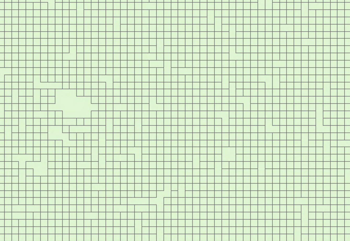
I have a DEM file, I generated slope/aspect(raster format) using the Surface tool, then I used Conversion tool convert them into polygons(simplified polygons checked). What I wanted are TIN(triangular shaped polygons) looked polygons, but what I got are lots of adjacent square polygons, as below. I tried to use the Eliminate tool to merge some small polygons, but still looked not right. Is there anyone know what I missed? Great thanks!#raster to polygon
- Mark as New
- Bookmark
- Subscribe
- Mute
- Subscribe to RSS Feed
- Permalink
- Report Inappropriate Content
There are two options
- simplified
- non-simplified
Yours blocky/cell-like is non-simplified... even though claim it isn't
Raster to Polygon—Conversion toolbox | ArcGIS Desktop
You might not like the result.
maybe you want a Tin to begin with? (Raster to points then Tin)
Is your dem reclassied to integer format?
he input raster can have any cell size and must be a valid integer raster dataset.
- Mark as New
- Bookmark
- Subscribe
- Mute
- Subscribe to RSS Feed
- Permalink
- Report Inappropriate Content
Hi Dan,
Thanks for your reply. I'm sure I checked the simplified box.

I want to get polygon files of slope/aspect, then overlay/tessellate them into polygons, so that parameter values in a single polygon are all the same. But I don't want these many polygons, any ideas?
My DEM is not relassified and it's float.
- Mark as New
- Bookmark
- Subscribe
- Mute
- Subscribe to RSS Feed
- Permalink
- Report Inappropriate Content
slope and aspect are undoubtedly floating point rasters as well and not integer rasters.
I am surprised that you could use the tool... unless you converted the rasters to integer format.
I suspect the output is the result of a wrong field being used during the conversion... perhaps you might revisit your inputs or at least scale your rasters down to integer format using the Spatial Analyst's Int tool.
- Mark as New
- Bookmark
- Subscribe
- Mute
- Subscribe to RSS Feed
- Permalink
- Report Inappropriate Content
Sorry for the misunderstanding. Of course, after get slope/aspect from original DEM, I use Int tool transfer values into Integers.
- Mark as New
- Bookmark
- Subscribe
- Mute
- Subscribe to RSS Feed
- Permalink
- Report Inappropriate Content
Hi Dan,
Thanks for your prompt reply again! There are in total two fields in the aspect file-- value and count. I just tried to convert the aspect from raster to polygon choosing the other field(count) which gives me the same blocky like result.

- Mark as New
- Bookmark
- Subscribe
- Mute
- Subscribe to RSS Feed
- Permalink
- Report Inappropriate Content
yes, count would be the wrong field for sure
- Mark as New
- Bookmark
- Subscribe
- Mute
- Subscribe to RSS Feed
- Permalink
- Report Inappropriate Content
You wrote "I want to get polygon files of slope/aspect, then overlay/tessellate them into polygons". You seem to have Spatial Analyst extension, why not just use the Zonal Statistics as Table or the Zonal Statistics tools to populate your polygon file with the raster slope values?
Be cautious when working with aspect as a summarising aspect values (0-360) will not work. For example, summarising a northerly aspect (315 to 45 degrees) may give you an average of a southerly aspect.
- Mark as New
- Bookmark
- Subscribe
- Mute
- Subscribe to RSS Feed
- Permalink
- Report Inappropriate Content
Hi Mervyn,
Thanks! I will try what you said. But I found a way to do this is generate TIN from the original DEM, then use 3D Analysis/Conversion/ TIN Triangle tool to generate slope/aspect as a vector file. That will give me the triangular look polygons. But am still finding a way to decrease the number of polygons, thinking of the Elimination tool.