- Home
- :
- All Communities
- :
- Products
- :
- ArcGIS Survey123
- :
- ArcGIS Survey123 Questions
- :
- Re: Tile Package for Survey123 Offline Basemap
- Subscribe to RSS Feed
- Mark Topic as New
- Mark Topic as Read
- Float this Topic for Current User
- Bookmark
- Subscribe
- Mute
- Printer Friendly Page
Tile Package for Survey123 Offline Basemap
- Mark as New
- Bookmark
- Subscribe
- Mute
- Subscribe to RSS Feed
- Permalink
- Report Inappropriate Content
This is my first time creating tile packages and I have been unsuccessful getting a tile package to serve as a basemap for my survey the map is usable offline. Following the "Prepare basemaps for offline use" documentation, I have tried (1) sharing my tile package online with my organization and adjusted the survey.info file to include the shared map location and (2) putting my tile package in the My Survey>Maps folder and selecting the tile package as the default map when creating the survey through Survey123 Connect for ArcGIS.
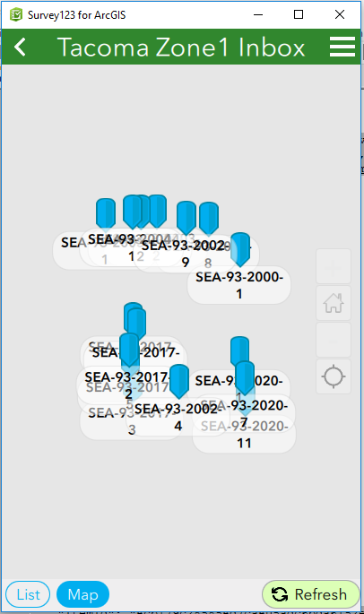
However, in both cases, the result looks like this. My points are there, but no basemap.
I believe this an error with my tile package. Any suggestions on how to confirm this? Or any more references for the map options in Survey123 Connect for ArcGIS that explore other options for offline basemaps?
- Mark as New
- Bookmark
- Subscribe
- Mute
- Subscribe to RSS Feed
- Permalink
- Report Inappropriate Content
Hi Carrie,
How did you create the tile package? Do you know what projection it is in?
- Mark as New
- Bookmark
- Subscribe
- Mute
- Subscribe to RSS Feed
- Permalink
- Report Inappropriate Content
Thanks for having a look at my post, James.
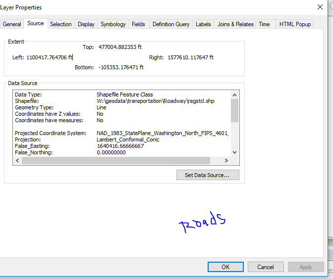
I created my tile package using the Create Map Tile Package tool. The projection of all the data sources is "NAD_1983_StatePlane_Washington_North..." I think that is what you are referring to in your question about the projection.
I also tried creating a tile package by using the File>Share As> Tile Package... pathway but the process took more than 6 hours and I abandon that effort. When I did that, I got spacial reference error across errors ("The data frame has an unknown spacial reference" and "Layer's spacial reference differs from the ArcGIS runtime content's target spacial reference"). I resolved the first error by adjusting the dataframe's projected coordinate system to the same as the layers' projected coordinate system but was not able to resolve the second error.
Picture of my layer's projection coordinate system which I matches when setting my data frame's projection coordinate system.
- Mark as New
- Bookmark
- Subscribe
- Mute
- Subscribe to RSS Feed
- Permalink
- Report Inappropriate Content
Hi Carrie,
Survey123 only supports Web Mercator projection at this time.
- Mark as New
- Bookmark
- Subscribe
- Mute
- Subscribe to RSS Feed
- Permalink
- Report Inappropriate Content
I've successfully resolved this issue using by creating a tile package using the Tile Package Kreator and copying the .tpk file in the media folder of the survey (following the instruction on this blog post: https://community.esri.com/groups/survey123/blog/2017/01/31/taking-your-maps-offline-with-tile-packa...).