- Home
- :
- All Communities
- :
- Products
- :
- Imagery and Remote Sensing
- :
- Imagery Questions
- :
- Re: Sentinel 2 Imagery Resolution
- Subscribe to RSS Feed
- Mark Topic as New
- Mark Topic as Read
- Float this Topic for Current User
- Bookmark
- Subscribe
- Mute
- Printer Friendly Page
Sentinel 2 Imagery Resolution
- Mark as New
- Bookmark
- Subscribe
- Mute
- Subscribe to RSS Feed
- Permalink
- Report Inappropriate Content
I have been having a look at newly released Sentinel 2 imagery - https://www.esri.com/arcgis-blog/products/arcgis-living-atlas/imagery/sentinel-2-more-than-meets-the...
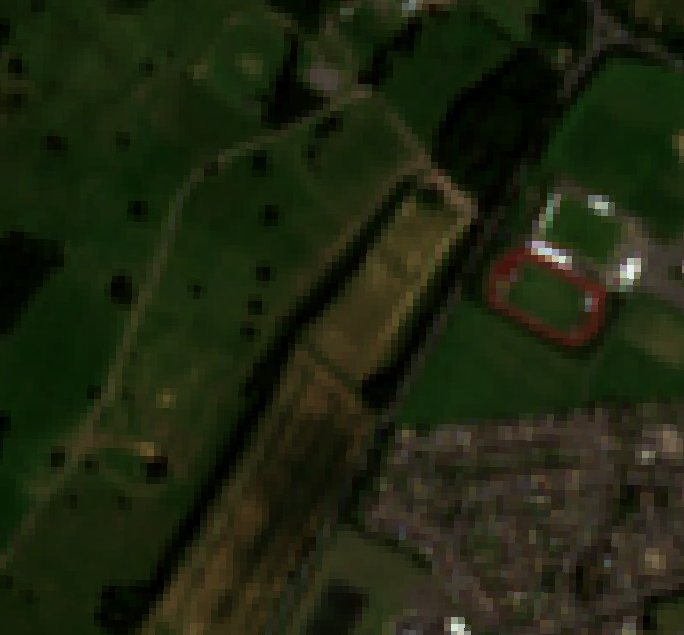
The resolution of the imagery seems to be coming at very poor, see imagery I have pulled out for my area of interest.
From online it says resolutions are 10m and 60m, is this what 60m looks like, I usually work with 25cm or better.
Is this what 10m or 60m looks like?

- Mark as New
- Bookmark
- Subscribe
- Mute
- Subscribe to RSS Feed
- Permalink
- Report Inappropriate Content
Yes that looks like the RGB (4,3,2) band combination at 10m resolution with Bicubic/Bilinear sampling.
With Nearest Neighbour sampling you'll get this:
- Mark as New
- Bookmark
- Subscribe
- Mute
- Subscribe to RSS Feed
- Permalink
- Report Inappropriate Content
Exactly: 4 visible and near-infrared Bands are provided at 10m resolution, 6 red-edge/swir band at 20m and 3 athmospheric correction bands at 60m (Sentinel-2 - ESA Operational EO Missions - Earth Online - ESA ).
The advantage of Sentinel-2 is more at temporal than at spatial resolution. You get free data to detect changes in landscapes instantaneously.
The Sentinel Explorer shows the impressive capabitilies of an Esri Image Service: it is just one service which includes an rolling archive over the last 14 months AND a mass of different predefined renderer for getting specific band combinations (Natural Color, Color infrared...) or on-the-fly calculated band relations (Vegetation indices, urban index...). The image service just provided real pixels, not just "images" - so you can use it for geoprocessing analysis as well. This can be seen using the mask or the change detection functions inside the Sentinel Explorer.
The service is free for any Esri Named User.
- Mark as New
- Bookmark
- Subscribe
- Mute
- Subscribe to RSS Feed
- Permalink
- Report Inappropriate Content
Just a huge thank you to Esri for providing us with the Sentinel image service. It is really very useful and will be a very important resource going forward.
Could you please check your Normalized Burn Ratio template, it is not displaying any variance in the data and I have tried different stretchings.
The App Tutorial functionality within the Sentinel Explorer also made me realise just how powerful this app is really is. I encourage others to try out the built in tutorial.
- Mark as New
- Bookmark
- Subscribe
- Mute
- Subscribe to RSS Feed
- Permalink
- Report Inappropriate Content
You should also have a look at the Sentinel-hub Playground to play with visualization options as well as create your own custom indices. Unfortunately the Playground app does not allow you to do pixel identification like the Esri Sentinel Explorer app, but the possibilities are endless if you start using the API and OGC services provided by Sentinel-hub.
- Mark as New
- Bookmark
- Subscribe
- Mute
- Subscribe to RSS Feed
- Permalink
- Report Inappropriate Content
Hi "FC Basson"
thanks for contributing. Sure you know but for all others: You can create ANY custom band combination (even in the Sentinel App) and create any custom index with the Sentinel Services in ArcGIS Pro - PLUS there are many more and classification tools in ArcGIS Pro (and in ArcGIS Desktop/ArcMap). Here a few ArcGIS Pro hints:
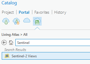
Load the Sentinel-2 Views into ArcGIS Pro ...
Then go to the ImageService Layer Tab ... look at the "Indices Group" ...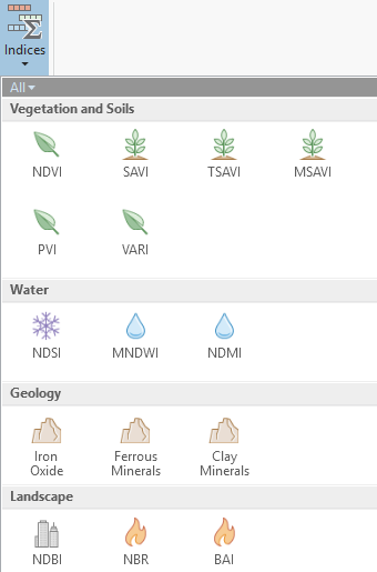
This would be your FIRST selection of some pre-configured additional indices.
The Classification Wizard and the Segmentation/Classification Tools will help you get more ...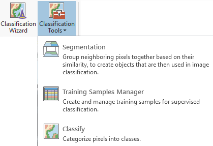
If you have other Indices or process chains you want to use/create: have a look at the documentation how to
write Raster Functions (Raster functions—ArcGIS Pro | ArcGIS Desktop ) or get the samples and documentation on python raster functions from Github (GitHub - Esri/raster-functions: A curated set of lightweight but powerful tools for on-the-fly image... ).
Finally, the Sentinel/Landsat Imagery app template (GitHub - Esri/Imagery-Apps: Example JavaScript source code for ArcGIS imagery apps (Landsat Explorer... ), the Image Interpretation app template (GitHub - Esri/Image-Interpretation: Use this template to create an app to better visualize and inter... ), the Imagery Viewer app template (GitHub - Esri/imagery-viewer-template: With the Imagery Viewer configurable template, create apps to... ), the change detection app template (GitHub - Esri/image-change-detection-template: With the Image Mask configurable template, create an ... ) and the widgets for raster functions within App Builder (GitHub - Esri/WAB-Image-Services-Widgets: Web AppBuilder widgets for Image Services (WABIS) ) are shared by Esri and can be used, modified, extended at your own will.
- Mark as New
- Bookmark
- Subscribe
- Mute
- Subscribe to RSS Feed
- Permalink
- Report Inappropriate Content
Hey,
How do you execute custom band math in Sentinel App?
Thank you,
- Mark as New
- Bookmark
- Subscribe
- Mute
- Subscribe to RSS Feed
- Permalink
- Report Inappropriate Content
You can't - only custom band combinations and any custom index e.g. (B01-B02)/(B01+B02)