- Home
- :
- All Communities
- :
- Products
- :
- ArcGIS Pro
- :
- ArcGIS Pro Questions
- :
- Re: What is your take on ArcGIS Pro
- Subscribe to RSS Feed
- Mark Topic as New
- Mark Topic as Read
- Float this Topic for Current User
- Bookmark
- Subscribe
- Mute
- Printer Friendly Page
What is your take on ArcGIS Pro
- Mark as New
- Bookmark
- Subscribe
- Mute
- Subscribe to RSS Feed
- Permalink
- Report Inappropriate Content
I have started using ArcGIS Pro for a project looking at Groundwater Vulnerability to Nitrate contamination. I decided that this would be a good project to use to really become acquainted with Pro. I am glad that I am using Pro, I am finding that it is truly much more responsive than using the desktop. Actions that would take upwards of of half hour or more are only taking seconds. I am been able to clip every statewide layer down to the county that I am modeling first. I took me a little bit to get used to the interface, and Esri has been very accommodating to help me get off and running.
There are some quirks with the interface that I would like to see changed or added in time, but all in all I am very impressed. I am wondering what everyone else who is using Pro, what is your opinion of the product? Please give me your true thoughts.
Good job with this products usability.
Chad
- Mark as New
- Bookmark
- Subscribe
- Mute
- Subscribe to RSS Feed
- Permalink
- Report Inappropriate Content
Thank you Dan for your response I use much of the functionality that you listed as well. I would be good to see those items that we use on a regular bases added to pro. Good luck.
- Mark as New
- Bookmark
- Subscribe
- Mute
- Subscribe to RSS Feed
- Permalink
- Report Inappropriate Content
Dan, I'll do my best to provide some updates here:
Copy Parallel: Copy Parallel tool in PRO should be in 2.2 this summer.
- You can no longer perform statistics on-the-fly for a field in a table.
Yes you can. What's new in ArcGIS Pro 2.1—ArcGIS Pro | ArcGIS Desktop

- Viewing and using Tables is a royal pain in ArcGIS Pro. You can make a field wider in order to view lengthy text, but it will go right back to the default width if you scroll around in the table at all. Whenever you change the width of a field, the table will automatically scroll back to the top. There are also times when I have added data to a field, clicked the save button, and then the next time I view the table, that data I just entered is gone.
When you encounter issues like this, they should be reported to technical support so that an issue can be entered with the development team. This is likely related to Stop the ArcGIS Pro table view jumping around when I calculate attributes and that dev team has an issue entered that they're working on to get this fixed.
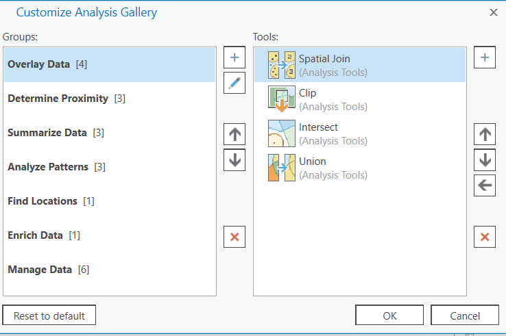
- I like to customize the Editor Tools Gallery by dragging other tools onto it from the Modify Features list, but the next time I open the Project, the tools I added are gone, and I have to drag them all over again.
Pro 2.2 this summer will have a customizable Edit tools gallery like we currently have for analysis tools:
- In ArcMap I can easily customize a Legend that I have added to a map, but in ArcGIS Pro it is an absolute nightmare to try to customize a Legend. It takes way too many steps and is in no way an easy process.
Any specifics on this one? The layout team is looking at improving the legend creation/modification experience, so if there are specific details about things that don't work well for you/are hard to find, etc. that would be good input for that team.
- The Attribute Transfer function in ArcMap is NOT available in ArcGIS Pro. This is one of the tools I use the most in ArcMap.
I'll check on this internally. In the meantime, I don't see it on the ArcGIS Ideas site so you might submit a new idea noting this as an ArcMap equivalency issue. I also searched and don't see that anything has been logged with technical support. I see that you're asking for it, and below in this thread, Steve Cole is asking for it, so there are bound to be a number of other users who really need this in order to bring their work over into Pro. Getting a better gauge on how many users that is will definitely help prioritize this.
- There is no Draw toolbar in ArcGIS Pro. I love the ability in ArcMap to add graphics in either Data View or Map View, but it is lacking in ArcGIS Pro.
This? Graphics and free text in ArcGIS-Pro maps!
- There is no Fillet Tool in ArcGIS Pro.
It's on the list. Mentioned in this thread https://community.esri.com/ideas/14266-add-basic-editing-tools-to-pro-edit-toolbar?commentID=56102#c... and Where are the fillet, trim, and extend tools in ArcGIS Pro?
- Mark as New
- Bookmark
- Subscribe
- Mute
- Subscribe to RSS Feed
- Permalink
- Report Inappropriate Content
Hi Kory,
Instead of asking us to keep adding things to the ideas site why not get the Pro developers to just run Pro operations concurrently to the same in ArcMap/Catalog. If it exists, works and is faster keep it. If not go back to the drawing board.
I get the impression some people in Esri are not familiar with how the ArcGIS stack is used.
An easy one to get started with:
Ready:
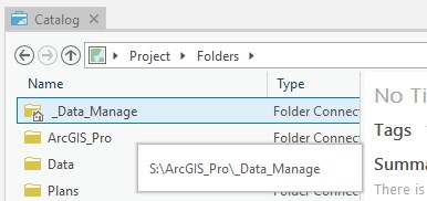
Check the assigned coordinate system of an aerial image.
Go:
Catalog: Because you can keep Catalog open on your 2nd monitor all it needs is a browse to the folder, right click, left click and short scroll and TIME!
Pro: Still trying to figure out where to save my blank new project.
So - where do we file this?
A, New Idea - Make Pro faster or,
B, Issue - Make Pro faster? Filing a support issue for this will take an Esri staff member time to review, find the right team member to allocate job to, email the customer for more data, and so it goes on. Not my idea of being productive.
C, None of the above?
Should we rely on the customer to verbalize the actual problem during a period of frustration?
This really has to do with teaching them/us to customize/configure Pro to not make a new folder/FGDB/etc for a specific blank project or create a data management-specific Project that contains links to all data sources and is pinned to the opening screen.
With my knowledge of Pro no matter what you do you still end up with having to click many more times to get to the answer - That ladies & gentleman is the real problem.
Multiply that process across the entire Pro feature set and as far as I can see you end up in negative territory for many very common use cases.
If the business process is ArcGIS Online focused, once you have layers in Pro, the odds are stacked strongly to the Pro corner again.
From Dan:
- In ArcMap I can easily customize a Legend that I have added to a map, but in ArcGIS Pro it is an absolute nightmare to try to customize a Legend. It takes way too many steps and is in no way an easy process.
Any specifics on this one? The layout team is looking at improving the legend creation/modification experience, so if there are specific details about things that don't work well for you/are hard to find, etc. that would be good input for that team.
Get the developer & product manager to make a real map with real data in Desktop & Pro. Take out a stop watch & heart rate monitor. Do it with the idea that you will be charging a client for your time. Some of us use ArcGIS to make a living.
You have to make a 100 maps and have a tight deadline. You have doc control standards to follow. Keep in mind that suddenly billing more hours for the same type of work doesn't go down well with most clients.
Say a simple single step operation takes longer and accumulates to 5min per day. If you have 5 staff using the tool that is just under 3 hours per week. Keeping the math simple we say it's 10 man hours per month lost. At $100 per hour (low end of town) that is a $1000 per month either the user or his clients have to pay due to "improvements" in a software stack. Over a year that is the cost of a license or two.
Think about it.
- Mark as New
- Bookmark
- Subscribe
- Mute
- Subscribe to RSS Feed
- Permalink
- Report Inappropriate Content
"Instead of asking us to keep adding things to the ideas site why not get the Pro developers to just run Pro operations concurrently to the same in ArcMap/Catalog. If it exists, works and is faster keep it. If not go back to the drawing board."
Yes!
- Mark as New
- Bookmark
- Subscribe
- Mute
- Subscribe to RSS Feed
- Permalink
- Report Inappropriate Content
Hi Chris,
Thanks for the input. We want you to be productive with Pro so I took a look at this workflow to see what can be improved in Pro to make the workflow, if not faster, at least the same as ArcMap.
Ready:
Check the assigned coordinate system of an aerial image.
Go:
Catalog: Because you can keep Catalog open on your 2nd monitor all it needs is a browse to the folder, right click, left click and short scroll and TIME!
Pro: Still trying to figure out where to save my blank new project.
I'm assuming you just have a file in a Windows directory on one monitor and you want to know its coordinate system so you're using ArcCatalog on a second monitor? Because if we have the layer in ArcMap, I would just right-click either the layer in the Table Of Contents > Properties and scroll down to the spatial reference, or right-click the file in the Catalog window inside ArcMap (I usually have that open) > Properties and scroll down to the spatial reference.
In ArcGIS Pro, the steps are actually exactly the same. I have a raster layer in my Contents pane, so I right-click > Properties and see the spatial reference. Or, if I have the Catalog Pane open (like I have the Catalog window open in ArcMap), I find the file, right-click > Properties and find the spatial reference.
If we're talking about the "file in a Windows directory and I want to know the coordinate system" scenario, you have ArcCatalog open on a second monitor. The equivalent in Pro would be to have it open on your second monitor with the Catalog View open. Again, though, in ArcCatalog we right-click > Properties and get the spatial reference. In Pro's Catalog View we right-click > Properties and get the spatial reference.
So on this particular workflow, I don't see the difference. Since there is no difference with that workflow, it sounds like the major pain point is
This really has to do with teaching them/us to customize/configure Pro to not make a new folder/FGDB/etc for a specific blank project or create a data management-specific Project that contains links to all data sources and is pinned to the opening screen.
Yes, this is feedback that we're well aware of and is a combination of a few different ideas on the Ideas site. I want to assure you that the development team is getting this feedback and we are looking at ways to continue improving Pro so that you can maintain the high level of productivity that you've become accustomed to when working with ArcMap/ArcCatalog...
Thanks again for your input. I just wanted to reach out so you know we are listening and we do take this feedback seriously.
- Mark as New
- Bookmark
- Subscribe
- Mute
- Subscribe to RSS Feed
- Permalink
- Report Inappropriate Content
Hi Kory,
I had a go at setting up a "Data Management" project in Pro and most of my observations still stand.
In the comparison between getting a feature's coordinate system details in Catalog vs Pro we still have Catalog come out ahead once you have opened the Properties dialog.
In Catalog you scroll up & down to see all the key info. In Pro you have to scroll, click to select a category, then scroll some more. That sums up a lot of Pro experiences: A prettier interface forces a user to click & scroll a lot more than in ArcMap/Catalog.
Achieving the same task should not take longer no matter how pretty the interface.
In an ideal world the Catalog experience should have evolved into an interface similar to that of Directory Opus. It is a multi-tabbed, multi-frame Windows Explorer replacement. I am sure the Australian company would be happy to license their framework to Esri.
Is there a way to disable tooltips in Pro?
Having these little dialogs try to keep up with a fast workflow is just distracting. It does not matter if a computer is fast enough; due to the all pervasive "beautiful" interface the tooltips have to fade in & out by which time I have moved on or already started an operation on the folder/layer/map/
Please tell me what the value of the tooltip is in this screenshot?
- Mark as New
- Bookmark
- Subscribe
- Mute
- Subscribe to RSS Feed
- Permalink
- Report Inappropriate Content
Hi Chris,
Thanks for the feedback. Starting with the easy question, is there a way to turn off the hover tips on Catalog View/Pane?
Yes, from Catalog Pane, turn those off from the burger:
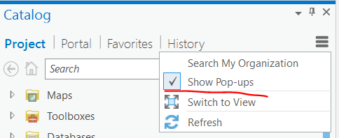
If you're in Catalog View, turn them off from the Options group in the ribbon:
Can we get a bit more detail on this:
In Catalog you scroll up & down to see all the key info. In Pro you have to scroll, click to select a category, then scroll some more. That sums up a lot of Pro experiences: A prettier interface forces a user to click & scroll a lot more than in ArcMap/Catalog.
When you say that you scroll up and down to see all the key info, where in the Properties dialog are you talking about?
Here I'm on the XY Coordinate System tab:
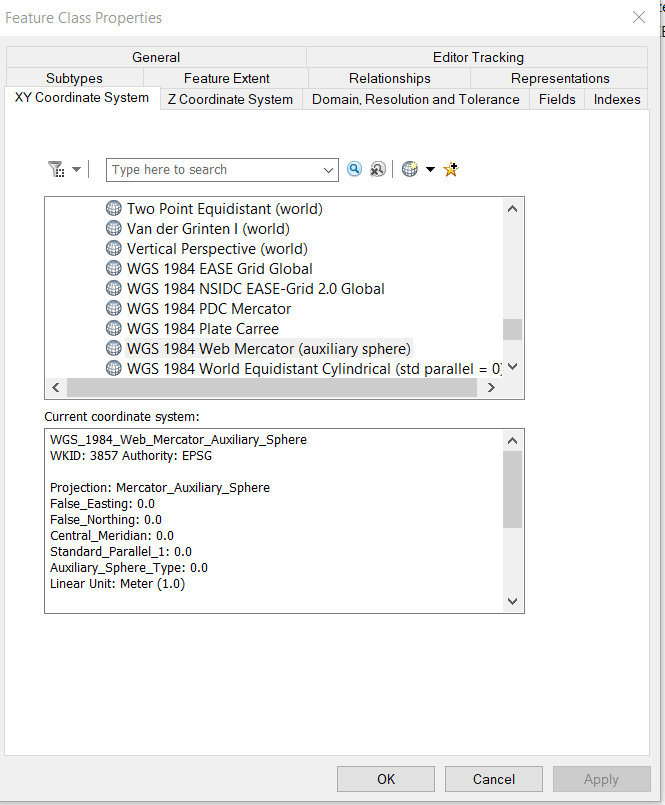
I can scroll through different coordinate systems, but need to click on different tabs to get other Feature Class Properties.
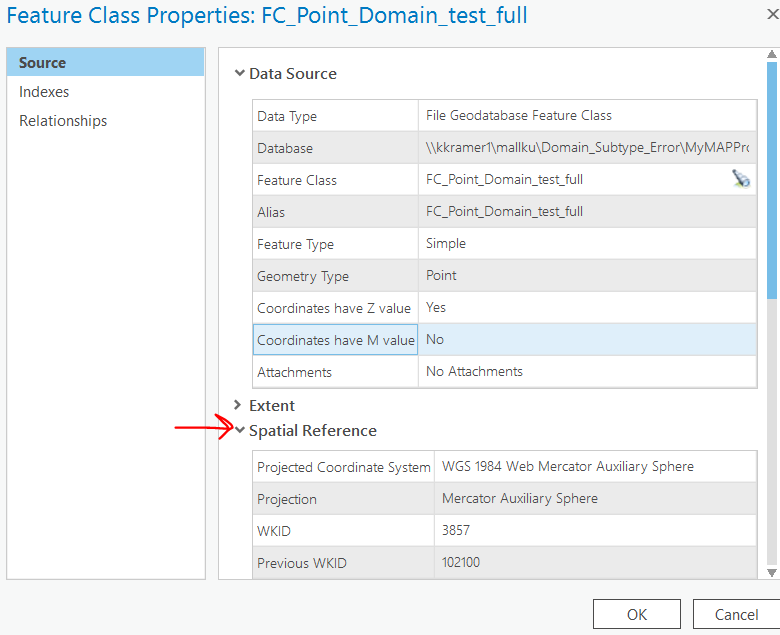
In the current release of Pro, we aren't exposing some of those properties (like spatial reference) from Catalog, only from the layer. ArcGIS Pro: Include/Add Extent and Spatial Reference to Feature Class Source Tab will be in Pro 2.2, so let's use that as a closer comparison to ArcCatalog.
When I open the Feature Class Properties, you are correct that I will have to expand something like Extent or Spatial Reference if I want to see those properties.
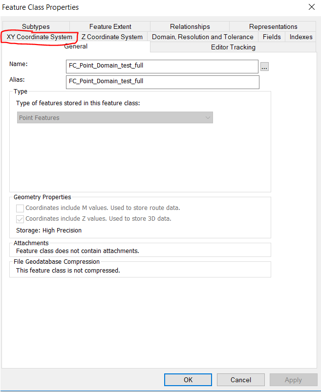
But from a "number of clicks" standpoint, I'm not sure how that is different than having to click on a tab in the ArcCatalog UI:
Can you help me understand specifically where in the UI the problem is in Pro vs. ArcCatalog? Your input is valuable, I just need to make sure that I get what you're talking about so that we can work with the feedback.
Thank you!
- Mark as New
- Bookmark
- Subscribe
- Mute
- Subscribe to RSS Feed
- Permalink
- Report Inappropriate Content
Hi Kory,
I was referring to the Properties dialog for raster layers - as per the original comparison. My ESP transmitter must be broken. It is a different case for vector layers but, ...... Catalog is still ahead once the properties box is open with a single click to get to the tab instead of a scroll & click 🙂
If you happened to have looked at the coordsys tab of a previous layer it will come up as selected the next time round.
Tell the developers to print a copy of the Amazon 1-Click button and frame it next to their monitor 😉

It is all about reducing friction in tasks.

Pro is competing with the years of development of Desktop but there seems to be a disconnect in the UI vs UX design philosophy. You also have to incorporate more than a decade of muscle memory / reflex in the design criteria.
As GIS people we (most) are organically built to search for new & better ways of doing things. We get cranky when we have a good way and are told we will be improving by going backwards. Many in the industry are also typical introverts so the actual number of unhappy people are likely to be higher than the numbers verbalizing in forums such as these. In almost all cases the discontent can be reduced by changing the messaging going to customers. I am sure Esri has a team of messaging experts but they may need to be let out the door and into the real world.
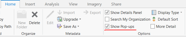
Brilliant on the "Show Popups" setting.
Last I looked for something like this was in <2.0 and I missed it in the What's New or Release Notes for 2.1.
- Mark as New
- Bookmark
- Subscribe
- Mute
- Subscribe to RSS Feed
- Permalink
- Report Inappropriate Content
Thanks for the clarification, Chris. It looks like in Pro there was a 'Find data source properties' search box added. This is probably because of the amount of scrolling that needs to be done to get to raster properties.
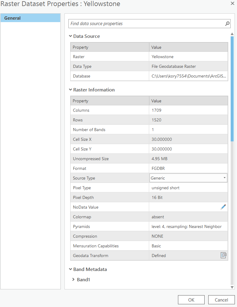
So if I'm looking for the coordinate system, I start to search for that and it takes me to the raster's Spatial Reference information:

But yes, I'll admit that you have to click again to expand the Spatial Reference info.
In playing with this, it looks like there could be some improvements made to the search capabilities, so I'll make sure that team is aware of that opportunity.
Thank you for the continued input. We are listening and conveying feedback to the development teams.
Cheers,
Kory
- Mark as New
- Bookmark
- Subscribe
- Mute
- Subscribe to RSS Feed
- Permalink
- Report Inappropriate Content
My every expanding list has some duplicates with Dan but here's my list why I haven't bothered using ArcGIS Pro:
* Can't show vertices during editing using the V key shortcut.
* Can't export to Illustrator format.
* Can't create folder connection to root level of drive
* Can't move callout leader line anchor point independantly of the entire callout.
* Can't open program without having to create a project.
* Can't pause drawing.
* Doesn't support personal GeoDbs.
* Can't calculate geometry as right-click option in table view.
* Can't do Summary Statistics, right-click in Arcmap style.
* Can't copy/paste features
* Can't clip map data frame to a shape
* Can't get x,y coordinates for location clicked using the identify tool
* Can't individually label features like Arcmap
* Can't copy features parallel
* No Eye Dropper Tool
* Can't split features by percentage/length/equal number of parts
* Can't nudge item locations using arrow keys
* No Attribute Transfer Tool / functionality