- Home
- :
- All Communities
- :
- Products
- :
- ArcGIS Data Reviewer
- :
- ArcGIS Data Reviewer Questions
- :
- Re: Topology check not picking up blatant errors?
- Subscribe to RSS Feed
- Mark Topic as New
- Mark Topic as Read
- Float this Topic for Current User
- Bookmark
- Subscribe
- Mute
- Printer Friendly Page
Topology check not picking up blatant errors?
- Mark as New
- Bookmark
- Subscribe
- Mute
- Subscribe to RSS Feed
- Permalink
- Report Inappropriate Content
ArcMap ver. 10.2
I have a line feature. It is the result of two separate polygon features being converted to line, and merged together. A high number of dangles are expected. However, my error checker is not finding any of these errors.
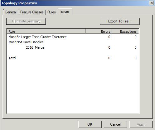
Topology properties:
Feature class: 2016_Merge
Rule: "Must Not Have Dangles (line)"
Initially, I created the topology through model builder, and it didn't work. I deleted it and created it manually, but I am still running into the same issue.
I am selecting 'Validate Entire Topology'. The correct topology has been selected and is the only topology open in the mxd.
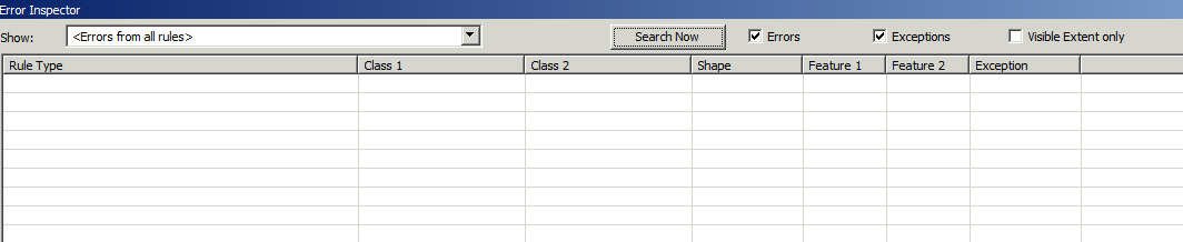
On the Error Inspector, I have checked both the Exceptions and the Errors list, and have disabled 'Visible Extent only'.
I have tried everything I can think of - am I missing something obvious?
The spatial reference for both the feature dataset and geodatabase and the dataframe in the mxd are all the same, as well (UTM10)
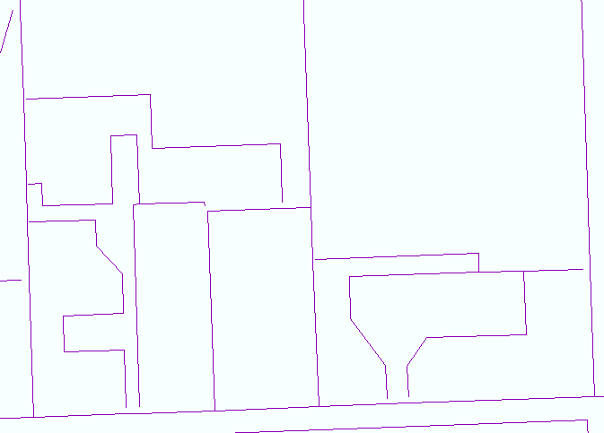
Here is an example of the line feature class I am working with, which appears to have dangles:
Error Inspector:
Topology properties:
- Mark as New
- Bookmark
- Subscribe
- Mute
- Subscribe to RSS Feed
- Permalink
- Report Inappropriate Content
For starters, is the feature class "2016_Merge" in a Feature Dataset within a File Geodatabase? I'm guessing it is not based on the filename, which starts with a number (which would not be allowed). If your feature class is not in a Feature Dataset in a File Geodatabase, I would suggest placing it there and then creating the topology. Then validate, start an editing session on it, then open the Error Checker. Give that a try and see if it resolves the issue.
Designing a geodatabase topology—Help | ArcGIS for Desktop
Creating a topology—Help | ArcGIS for Desktop
Chris Donohue, GISP
- Mark as New
- Bookmark
- Subscribe
- Mute
- Subscribe to RSS Feed
- Permalink
- Report Inappropriate Content
Not sure your problem was resolved. Maybe try run the following script. It runs through a dataset in geodatabase identifying lines with dangles.
import arcpy
import os
#This Script iterates through datasets, identifies line features and applies creates topology and exports topology errors
arcpy.env.overwriteOutput = True
# Input variables

arcpy.env.workspace = r"C:\MyProjects\MyProject.gdb"

input_dataset = r"C:\MyProjects\MyProject.gdb\fds"
wert = r"C:\MyProjects\MyProject.gdb\fds"
topo_name = "Topology"
cluster_tol = 0.001
input_fc = r"C:\MyProjects\MyProject.gdb\fds\fc1 1 1;C:\MyProjects\MyProject.gdb\fds\fc2 1 1"
rules = r"'Must Not Have Dangles (Line)' C:\MyProjects\MyProject.gdb\fds\fc1 # C:\MyProjects\MyProject.gdb\fds\fc1 #"
validate = "true"

out_topo = arcpy.CreateTopology_management(input_dataset, topo_name, cluster_tol)
print("Created topology.")
r = rules.rsplit(" ", 4)
print (r)
print("Finished3.")
for rule in r:
 #print("Finished3.")
 rule_type = r[0].replace("'","")
 print( rule_type)
 in_fc1 = r[1]
 print(in_fc1)
 subtype1 = r[2]
 print(subtype1)
datasets = arcpy.ListDatasets(feature_type='feature')
datasets = [''] + datasets if datasets is not None else []
#rulesL = rules.split(";")
for ds in datasets:
 for fcs in arcpy.ListFeatureClasses(feature_dataset=ds):
 path = os.path.join(arcpy.env.workspace, ds, fcs)
 print(path)
 sasa2 = '%s' % fcs #identify the feature class in the iteration
 print (sasa2)
 print "11111111111111111111111111"
# Create the topology

 arcpy.AddFeatureClassToTopology_management(out_topo, fcs, 1, 1)
 print(arcpy.GetMessages())
 print "22222222222222222222"
 arcpy.AddRuleToTopology_management(out_topo, rule_type, fcs, subtype1)
 print(arcpy.GetMessages())

 print "333333333333333333333333"
 if validate == "true":
 #try:
 arcpy.ValidateTopology_management(out_topo)
 #except:
 print(arcpy.GetMessages())
 print "4444444444444444444444444444"

 arcpy.ExportTopologyErrors_management(out_topo, wert, sasa2)


print("Finished.")